Related Research Articles

Powellton is a census-designated place (CDP) in Fayette County, West Virginia, United States. The population was 619 at the 2010 census.

The Little Kanawha River is a tributary of the Ohio River, 169 mi (269 km) long, in western West Virginia in the United States. Via the Ohio, it is part of the watershed of the Mississippi River, draining an area of 2,320 mi² (6,009 km²) on the unglaciated portion of the Allegheny Plateau. It served as an important commercial water route in the early history of West Virginia, particularly in the logging and petroleum industries.
New Creek is an 18.4-mile-long (29.6 km) stream in eastern West Virginia, United States. It is the third major West Virginia tributary to the North Branch Potomac River. Via the Potomac, it is part of the watershed of Chesapeake Bay.
Lunice Creek is a 7.3-mile-long (11.7 km) tributary of the South Branch Potomac River, belonging to the Potomac River and Chesapeake Bay watersheds. The creek is located in Grant County, West Virginia. Lunice Creek is created by its North and South Forks and empties into the South Branch at Petersburg.
Tearcoat Creek is an 18.3-mile-long (29.5 km) free-flowing tributary stream of the North River, itself a tributary of the Cacapon River, making it a part of the Potomac River and Chesapeake Bay watersheds. The creek is located in central Hampshire County, West Virginia. Its name is believed to have been derived from the tearing of the coats of British soldiers by low-hanging branches as they forded the stream during either the French and Indian or the American Revolutionary Wars.

Mill Creek is a 14.0-mile-long (22.5 km) tributary stream of the South Branch Potomac River, belonging to the Potomac River and Chesapeake Bay watersheds. The stream is located in Hampshire County in West Virginia's Eastern Panhandle. Mill Creek flows into the South Branch west of Romney Bridge near Vanderlip along the Northwestern Turnpike.
Mill Creek is an 8.7-mile-long (14.0 km) tributary stream of Patterson Creek in Mineral County, West Virginia. It is also known as Mill Run.

Tuscarora Creek in Berkeley County, West Virginia, is an 11.4-mile-long (18.3 km) tributary of Opequon Creek, which drains into the Potomac River in the Chesapeake Bay watershed.
Big Run is a 4.4-mile-long (7.1 km) tributary stream of the South Branch Potomac River, belonging to the Potomac River and Chesapeake Bay watersheds. Big Run flows through the city of Romney and the campus of the West Virginia Schools for the Deaf and Blind in Hampshire County, West Virginia. The stream is known by local residents as Town Run and Town Creek.
Buffalo Creek is a 4.1-mile-long (6.6 km) free-flowing tributary stream of the South Branch Potomac River, itself a tributary of the Potomac River, making it a part of the Chesapeake Bay watershed. Buffalo Creek is located in west-central Hampshire County in the U.S. state of West Virginia. Because the stream flows through several small farms, Buffalo Creek primarily serves agriculture purposes with segments used for livestock watering.

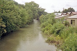
Deckers Creek is a 24.6-mile-long (39.6 km) tributary of the Monongahela River that runs through north-central West Virginia. It begins west of Arthurdale and flows southeast, then north, then northwest towards Morgantown, where it empties into the Monongahela River. The stream has been contaminated by various sources, though largely due to extractive resource mining and improper sewage disposal. Recently, a conservation effort has been launched and conditions are improving, as the area continues to develop for recreational purposes.

Indian River is a 59.1-mile-long (95.1 km) tributary of the Manistique River on the Upper Peninsula of Michigan in the United States. It rises out of Hovey Lake at 46°17′36″N86°42′20″W on Hiawatha National Forest land in Alger County and flows south and east through a lake district and on through Schoolcraft County. The river flows into the 8,659 acre (35 km2) Indian Lake at 46°17′36″N86°42′20″W and flows out at 45°59′30″N86°17′15″W. It then flows east and south about 2.5 miles where it merges with the Manistique River, which then flows through Manistique and into Lake Michigan at 45°56′56″N86°14′45″W.
Patterson Creek is a 51.2-mile-long (82.4 km) tributary of the North Branch Potomac River in West Virginia's Eastern Panhandle, in the United States. It enters the North Branch east of Cumberland, Maryland, with its headwaters located in Grant County, West Virginia. Patterson Creek is the watershed for two-thirds of Mineral County, West Virginia. The creek passes through Lahmansville, Forman, Medley, Williamsport, Burlington, Headsville, Reeses Mill, Champwood, and Fort Ashby.
Slate is an unincorporated community in Buchanan County, Virginia, in the United States.
Hunter Fork is a creek in Barbour County, West Virginia. It is a tributary of Sugar Creek, which flows into the Tygart Valley River.
Roaring Creek is a stream in the U.S. state of West Virginia. It is a tributary of the Tygart Valley River. It rises on the western slopes of Rich Mountain, flows for approximately 13 miles, and joins the Tygart about 2 miles downstream of Aggregates, West Virginia.
Bophumpa Creek is a stream in Holmes County in the U.S. state of Mississippi. It is a tributary to Fannegusha Creek.
Teter Creek is a stream in the U.S. state of West Virginia. It is a tributary to the Tygart Valley River.
Sugar Creek is a stream in the U.S. state of West Virginia. It is a tributary to Laurel Creek.
References
- ↑ U.S. Geological Survey Geographic Names Information System: Bills Creek (Sugar Creek tributary)
- ↑ Kenny, Hamill (1945). West Virginia Place Names: Their Origin and Meaning, Including the Nomenclature of the Streams and Mountains. Piedmont, WV: The Place Name Press. p. 115.
- ↑ Maxwell, Hu (1899). The History of Barbour County, West Virginia: From Its Earliest Exploration and Settlement to the Present Time. Acme publishing Company. p. 315.
39°06′27″N79°56′56″W / 39.10750°N 79.94889°W