Florida's Turnpike, designated as unsigned State Road 91, is a controlled-access toll road in the U.S. state of Florida, maintained by Florida's Turnpike Enterprise (FTE). Spanning approximately 309 miles (497 km) along a northwest–southeast axis, the turnpike is in two sections. The SR 91 mainline runs roughly 265 miles (426 km), from its southern terminus at an interchange with Interstate 95 (I-95) in Miami Gardens to an interchange with I-75 in Wildwood at its northern terminus. The Homestead Extension of Florida's Turnpike continues from the southern end of the mainline for another 48 miles (77 km) to US Highway 1 in Florida City. The slogan for the road is "The Less Stressway". The mainline opened in stages between 1957 and 1964, while the extension was completed in 1974. The turnpike runs through Miami, Fort Lauderdale, and West Palm Beach, where it parallels I-95, and through Orlando, where it crosses I-4.

State Road A1A (SR A1A) is a major north–south Florida State Road consisting of seven separate sections running a total of 338.752 miles (545.168 km) along the Atlantic Ocean, from Key West at the southern tip of Florida, to Fernandina Beach, just south of Georgia on Amelia Island. It is the main road through most oceanfront towns. Part of SR A1A is designated the A1A Scenic and Historic Coastal Byway, a National Scenic Byway. SR A1A is famous worldwide as a center of beach culture in the United States, a scenic coastal route through most Atlantic coastal cities and beach towns, including the unique tropical coral islands of the Florida Keys. SR A1A also serves as a major thoroughfare through Miami Beach and other south Florida coastal cities.

State Road 202 (SR 202) is a 13.042-mile-long (20.989 km) state highway that extends from U.S. Route 1, in Jacksonville, Florida to SR A1A, in Jacksonville Beach, near the Atlantic Ocean, just north of Ponte Vedra Beach, and includes a bridge over the Intracoastal Waterway. To locals, the road is better known as J. Turner Butler Boulevard, Butler Boulevard, or JTB. Despite being named as a boulevard, the road is a completely limited-access expressway, with the exception of the westernmost 0.5 miles between US 1 and Interstate 95 (I-95),. It was constructed in sections by the Jacksonville Transportation Authority. The first section opened in 1979, but the entire road was not completed until 1997.

State Road 80 is a 123.5 miles (198.8 km) route linking US 41 Business in Fort Myers and State Road A1A in Palm Beach. The road is the northernmost of three linking Southwest Florida to South Florida via the Everglades. Due to increasing traffic, State Road 80 has experienced upgrades and widening in various sections since 2000.
Florida State Road 7 (SR 7) is a major north–south artery in South Florida connecting U.S. Route 41 in the Little Havana section of Miami with 60th Street in Loxahatchee. All but the northernmost 6.5 miles (10.5 km) is instead signed as US 441, and has been since 1950.

Dixie Highway in Palm Beach and Broward counties carries two segments of the State Road 811 designation by Florida Department of Transportation, as well as the local County Road 811 in southeast Florida. The entire road comprises a section of the Dixie Highway, a National Auto Trail which eventually became a former routing of U.S. Route 1 after the route was shifted east to Federal Highway. One segment of SR 811 is in Broward County and the other is in Palm Beach County, Florida. The segments of SR 811 are supplemented by three shorter segments of CR 811, one of which is unsigned.
State Road 880 is a 0.475 miles (0.764 km) long state highway in Belle Glade, Florida, running from SR 80 and SR 15 east to State Road 717. From here, it continues east for almost 19 miles (31 km) to Twenty Mile Bend as County Road 880.

State Road 845 (SR 845), locally known as Powerline Road, is a 16.314-mile-long (26.255 km) north–south divided highway serving northern Broward County and southern Palm Beach County, Florida, United States. The route extends from an intersection with Sunrise Boulevard (SR 838) near downtown Ft. Lauderdale, north to an intersection with Glades Road (SR 808) near Boca Raton.

Military Trail is a 46.2-mile (74.35 km) long six-lane north–south arterial road in Broward and Palm Beach counties in South Florida. A portion of the road is designated State Road 809 (SR 809), but most of the road within Palm Beach County is locally maintained and signed as County Road 809 (CR 809), while the Broward County section exists without either designation.

Interstate 95 (I-95) is the main Interstate Highway of Florida's Atlantic Coast. It begins at a partial interchange with US Highway 1 (US 1) just south of downtown Miami and heads north through Jacksonville, and to the Georgia state line at the St. Marys River near Becker. The route also passes through the cities of Fort Lauderdale, West Palm Beach, Port St. Lucie, Titusville, and Daytona Beach.

State Road 867 and County Road 867 together create a 14.6-mile (23.5 km) long road known as McGregor Boulevard in Lee County, Florida, paralleling the Caloosahatchee River between Punta Rassa and Fort Myers. The entire road was formerly state-maintained.
State Road 804 (SR 804) is a 9.843-mile-long (15.841 km) east–west highway serving as a major commercial and commuter road through Boynton Beach in southern Palm Beach County, Florida. It is known locally and signed as Boynton Beach Boulevard for nearly all of its route, with the exception of when the road becomes concurrent with U.S. Route 1 (US 1 southward for two blocks, then continues along Ocean Avenue in downtown Boynton Beach to its eastern terminus at SR A1A. The western terminus of SR 804 is at the junction of US 441 / SR 7, close to the eastern boundary of the Loxahatchee National Wildlife Refuge and the historic northern boundary of The Everglades. Boynton Beach Boulevard adheres to Northwest 2nd Avenue in the Boynton Beach street numbering grid.

U.S. Highway 1 (US 1) in Florida runs 545 miles (877 km) along the state's east coast from Key West to its crossing of the St. Marys River into Georgia north of Boulogne and south of Folkston. US 1 was designated through Florida when the U.S. Numbered Highway System was established in 1926. With the exception of Monroe County, the highway runs through the easternmost tier of counties in the state, connecting numerous towns and cities along its route, including nine county seats. The road is maintained by the Florida Department of Transportation (FDOT).

U.S. Highway 17 (US 17) in Florida is a north–south United States Numbered Highway that runs 317 miles (510 km) from the Punta Gorda, Florida Metropolitan Statistical Area northeast to the Jacksonville metropolitan area.

U.S. Route 90 (US 90) in the state of Florida is the northernmost east–west United States Numbered Highway in the state. US 90 not only passes through the county seats of all the 16 counties it runs through on its course in Florida and is also the road upon which many of the county courthouses are located, but it was the first paved road in Florida. It is never more than six miles (9.7 km) from Interstate 10 (I-10) throughout the state. It runs as a two-lane highway through most of the sparsely populated inland areas of the Florida Panhandle, widening to four lanes through and near several towns. The speed limit is 55 mph (89 km/h) for all rural points west of Monticello, and it is 60 mph (97 km/h) on all rural points from where it enters Madison County as far as Glen St. Mary.

U.S. Route 98 is a major east-west thoroughfare through the U.S. state of Florida. Spanning 670.959 miles (1,079.804 km), it connects Pensacola and the Alabama/Florida state line to the west with Palm Beach and the Atlantic coast in the east. It is the longest US road in Florida, as well as the longest US road in any state east of the Mississippi River.

The Lamar Boulevard Bridge is a historic arch bridge carrying Texas State Highway Loop 343 over Lady Bird Lake in downtown Austin, Texas, United States. The bridge features six open-spandrel concrete arches spanning 659 feet (201 m) and carries tens of thousands of vehicles daily across the lake. Completed in 1942, the Lamar Boulevard Bridge was the second permanent bridge to cross the Colorado River, and one of the last Art Deco-style open-spandrel concrete arch bridges built in Texas. The bridge was named an Austin Landmark in 1993 and added to the National Register of Historic Places in 1994.
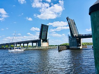
The Wilson Pigott Bridge is a small two-lane drawbridge located near Fort Myers Shores in Lee County, Florida. It is one of four drawbridges in Lee County. It is 27 feet tall.

