
Menorca or Minorca is one of the Balearic Islands located in the Mediterranean Sea belonging to Spain. Its name derives from its size, contrasting it with nearby Mallorca. Its capital is Mahón, situated on the island's eastern end, although Menorca is not a province and forms a political union with the other islands in the archipelago. Ciutadella and Mahon are the main ports and largest towns. The port of Mahon is the second biggest natural port in the world.

Mahón, officially Maó, and also written as Mahon or Port Mahon in English, is the capital and second largest city of Menorca. The city is located on the eastern coast of the island, which is part of the archipelago and autonomous community of the Balearic Islands.

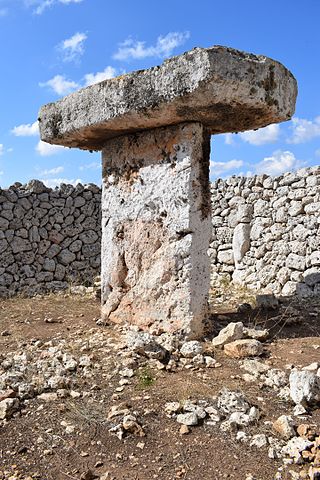
A taula is a Stonehenge-esque stone monument found on the Balearic island of Menorca. Taulas can be up to 5 metres high and consist of a vertical pillar with a horizontal stone lying on it. A U-shaped wall often encloses the structure.
Grimspound is a late Bronze Age settlement, situated on Dartmoor in Devon, England. It consists of a set of 24 hut circles surrounded by a low stone wall. The name was first recorded by the Reverend Richard Polwhele in 1797; it was probably derived from the Anglo-Saxon god of war, Grim.

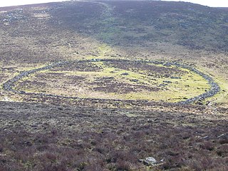
A talaiot, or talayot, is a Bronze Age megalith found on the islands of Menorca and Majorca forming part of the Talaiotic Culture or Talaiotic Period. Talaiots date back to the late second millennium and early first millennium BC. There are at least 274 of them, in, near, or related to Talaiotic settlements and the Talaiotic chamber tombs known as navetas. Talaiots pre-date the megalithic structures known as taulas, which are usually found nearby. While some Talaiots are thought to have had a defensive purpose, the use of others is not clearly understood. Some believe them to have served the purpose of lookout or signalling towers, as on Menorca, where they form a network. Talaiots generally take the form of circular or square buildings, and they may have been used as dwellings or meeting places. The talayots on Menorca have been much less prone to weathering than the ones found on Majorca. Despite this, very few grave goods have been found in Menorcan talayots, leading historians to believe that the island had a poorer economy than its larger neighbor.

Sant Lluís is a municipality on the tip of south-east Menorca in the Spanish Balearic Islands.

Dún Ailinne is an ancient ceremonial site on the hill of Cnoc Ailinne (Knockaulin) in County Kildare, Ireland. It is southwest of Kilcullen, near the R418 road to Athy. It is a large circular enclosure covering most of the hilltop; about 13 hectares. While there is no longer anything visible on the ground surface, archeological investigations show that there were once circular timber structures inside the enclosure during the Irish Iron Age.

Ses Païsses is a Bronze Age talayotic settlement on the southeastern outskirts of Artà in northeastern Majorca. It is one of the most important and best-preserved prehistoric sites in the Balearic Islands, although it is largely overgrown with woodland, mainly Quercus ilex, making it impossible to see the site as a whole.

Torre d'en Galmés is a Talayotic site on the island of Menorca, between Alaior and Son Bou, Menorca. The town developed from the start of the Talayotic era and expanded until the end of the Roman occupation, after which it was abandoned. Buildings were reoccupied and adapted by Muslim refugees from the Reconquista until the end of the Muslim occupation of the island.
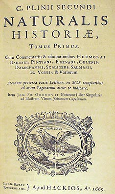
Sanisera was one of the Roman cities located in the island of Menorca, which was mentioned by Pliny the Elder in his book Naturalis Historia, III, 77–78 in the 1st century BC:
The Baleares, so formidable in war with their slingers, have received from the Greeks the name of Gymnasiæ. The larger island is 100 miles in length, and 475 in circumference. It has the following towns; Palma and Pollentia, enjoying the rights of Roman citizens, Cinium and Tucis, with Latin rights; and Bocchorum was a federate town. At thirty miles' distance is the smaller island, 40 miles in length, and 150 in circumference; it contains the states of Jamnon, Sanisera, and Magon.

Borġ in-Nadur is an archaeological site located in open fields overlooking St George's Bay, near Birżebbuġa, Malta. It is occupied by a Tarxien phase megalithic temple as well as the remains of a Bronze Age village which includes the earliest fortification in Malta. The site is located close to various Bronze Age cart ruts and silos, a Roman villa at Ta' Kaċċatura, as well as Saint George Redoubt which was built thousands of years later in 1715–1716.

The Talaiotic Culture or Talaiotic Period is the name used to describe the society that existed on the Gymnesian Islands during the Iron Age. Its origins date from the end of the second millennium BC, when the inaccurately named Pre-Talaiotic Culture underwent a crisis and evolved into the Talaiotic Culture. Its name is derived from the talaiots, which are the most abundant and emblematic structures from the prehistoric period of the Balearic Islands.

Cholesbury Camp is a large and well-preserved Iron Age hill fort on the northern edge of the village of Cholesbury in Buckinghamshire, England. It is roughly oval-shaped and covers an area, including ramparts, of 15 acres (6.1 ha), and measures approximately 310 m (1,020 ft) north-east to south-west by 230 m (750 ft) north-west to south-east. The interior is a fairly level plateau which has been in agricultural use since the medieval period. The hill fort is now a scheduled ancient monument.

Sa Cudia Cremada is the name of an archaeological site located in a land property called in the same way, in the outskirts of the city of Mahón, the capital of Menorca.

Eastern Biniac is a funerary naveta on the island of Menorca, where collective inhumations were made during the Bronze Age. Access to the site is possible from the Mahón–Ciudadela main road (Me-1), at kilometer 8.1, where there is a detour to the left which leads to the area called "Argentina". The Eastern Biniac naveta is located right at the entrance of the property that belongs to "Lloc de Menorca".

The settlement of Cala Morell is a Menorcan pretalayotic archaeological site which is located in Ciutadella de Menorca. It is situated on a 35-meter-high coastal headland which closes the northeast side of Cala Morell's bay. This promontory is protected by a dry-stone wall, which is found in the area where the promontory connects to solid ground. It shares many features with another site which is located some kilometers away from it: Es Castellet des Pop Mosquer.
The settlement of Torrellisar is highly altered due to the farming activities that have taken place in the area during the past few centuries since it was abandoned. Despite this, several remains can still be seen, such as its taula monument. The site is located near the road that connects Alayor and Cala en Porter. At km point 5,5 there is the rural road of Cotaina to the right and after 400 meters the site can be found.

Antigüedades célticas de la isla de Menorca is a book written by the Menorcan scholar Juan Ramis y Ramis (1746–1819). It was published in Mahón in 1818 and is the first book/treatise wholly dedicated to prehistory in Spain.
Museo de Menorca is a public institution located in the city of Mahón, Balearic Islands, Spain, which is devoted to the research and diffusion of the prehistory and history of Menorca.
Magheraboy causewayed enclosure is an early Neolithic enclosure located near Sligo town in northwest Ireland.

