

Birger Jarls torg is a public square on Riddarholmen in Gamla stan, the old town in Stockholm, Sweden. [1]
Birger Jarls torg is a public square on Riddarholmen in Gamla stan, the old town in Stockholm, Sweden. [1]
The square used to be called Riddarholmstorget, but was in the mid-19th century renamed Birger Jarls torg after Birger Jarl, traditionally attributed as the founder of Stockholm. A statue of him was erected on the square in 1854. It was designed by Swedish sculptor Bengt Erland Fogelberg (1786–1854). [2]
The square is surrounded by six palaces, today mostly occupied by various governmental authorities. The area is isolated from the rest of the city by the artery traffic route Centralbron. (See Riddarholmen.) Riddarholmen Church is on the southern side of the square.
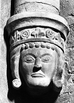
Birger Jarl, also known as Birger Magnusson, was a Swedish statesman and regent, jarl, and a member of the House of Bjälbo, who played a pivotal role in the consolidation of Sweden. His first marriage was to Princess Ingeborg of Sweden, which created his base of power. Birger led the Second Swedish Crusade, which established Swedish rule in Finland. Additionally, he is traditionally attributed with the foundation of the Swedish capital, Stockholm, around 1250. Birger used the Latin title of dux sveorum et guttorum.

Gamla stan, until 1980 officially Staden mellan broarna, is the old town of Stockholm, Sweden. Gamla stan consists primarily of the island Stadsholmen. Officially, but not colloquially, Gamla stan includes the surrounding islets Riddarholmen, Helgeandsholmen and Strömsborg. It has a population of approximately 3,000.
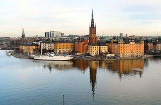
Riddarholmen is a small islet in central Stockholm, Sweden. The island forms part of Gamla Stan, the old town, and houses a number of private palaces dating back to the 17th century. The main landmark is the church Riddarholmskyrkan, used as Sweden's royal burial church from the 17th century to 1950, and where a number of earlier Swedish monarchs also lie buried.

Bengt Erland Fogelberg, also known as Benedict Fogelberg, was a Swedish sculptor.

Stortorget is a public square in Gamla Stan, the old town in central Stockholm, Sweden. It is the oldest square in Stockholm, the historical centre on which the medieval urban conglomeration gradually came into being. Today, the square is frequented by tens of thousands of tourists annually, and is occasionally the scene for demonstrations and performances. It is traditionally renowned for its annual Christmas market offering traditional handicrafts and food.
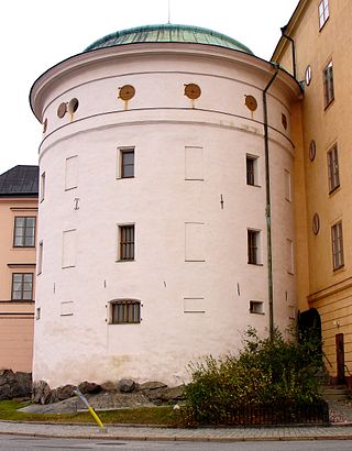
Birger Jarls torn is a defensive tower on the northwest corner of Riddarholmen, an islet in Gamla Stan, the old town of Stockholm.

Wrangel Palace is a townhouse mansion on Riddarholmen islet in Gamla Stan, the old town of Stockholm, Sweden.
Svea Court of Appeal, located in Stockholm, is one of six appellate courts in the Swedish legal system, as well as the oldest Swedish court currently in use. It is located in the Wrangel Palace, on Riddarholmen islet in Gamla Stan, the old town of Stockholm.
Gamla Riksarkivet is a building at Arkivgatan 3 on Riddarholmen in Stockholm, Sweden. Riksarkivet, the Swedish National Archives, were located in the building until 1968.
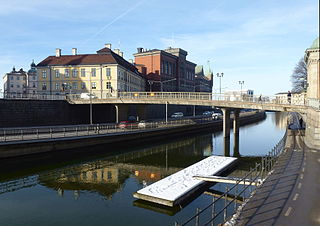
Riddarholmsbron is a bridge in Gamla stan, the old town in central Stockholm, Sweden, leading from the square Riddarhustorget on Stadsholmen to the smaller neighbouring island Riddarholmen.

Solgränd is an alley in Gamla stan, the old town of Stockholm, Sweden. It connects the Stortorget square to the street Prästgatan. It is a parallel street to Storkyrkobrinken, Ankargränd, Spektens gränd, and Kåkbrinken.

Brända Tomten is a small, triangular public square in Gamla stan, the old town in central Stockholm, Sweden.

Didrik Ficks Gränd is an alley in Gamla stan, the old town of Stockholm, Sweden. Stretching from Västerlånggatan to Stora Nygatan, it forms a parallel street to Sven Vintappares Gränd and Yxsmedsgränd while passing on the south side of the small square Sven Vintappares Torg.

Gåstorget is a small public square in Gamla stan, the old town in central Stockholm, Sweden, situated between the two alleys Överskärargränd and Gåsgränd.

Munkbrogatan is a street in the western part of Gamla stan, the old town in central Stockholm, Sweden. Stretching south between Munkbron and Mälartorget squares, it forms a parallel street to Munkbroleden and Lilla Nygatan, crossed by Yxsmedsgränd, Kåkbrinken, and Schönfeldts Gränd.

Karl Johans Torg is a public square between the old town Gamla stan and Slussen in central Stockholm, Sweden.

Källargränd is an alley in Gamla stan, the old town in central Stockholm, Sweden, connecting Slottsbacken, the slope south of the Royal Palace, to the square Stortorget. It forms a parallel street to Trångsund and is intercepted by Trädgårdsgatan.
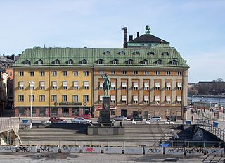
Slussplan is a street in Stockholm, Sweden. Located on the southern end of Gamla stan, the old town, and just north of Slussen and the public square Karl Johans Torg, it stretches west from Skeppsbron to Katarinavägen and Munkbroleden. South of the street is the statue of Charles XIV John, the creation of Bengt Erland Fogelberg and inaugurated in 1854. Järntorgsgatan leads north to the square Järntorget.

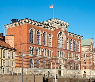
The Old Parliament House is the former seat of the Parliament of Sweden, located at Birger Jarls torg, on the Riddarholmen (island), in central Stockholm. It was used until January 1905, when the building on Helgeandsholmen was inaugurated.
Sculptures of Swedish rulers have been created since the 17th century. Most of the Swedish royal sculptures are located in Stockholm. Many of these can be seen in the city center around Stockholm Palace, in Gamla stan, Riddarholmen, Kungsträdgården and Stadshusterassen. Uppsala and Rottneros Park have three sculptures each. Gothenburg, Karlskrona, Örebro and Halmstad have two sculptures each.
59°19′30″N18°03′51″E / 59.32500°N 18.064152°E
| | This article about a location in Stockholm County, Sweden is a stub. You can help Wikipedia by expanding it. |