Related Research Articles

Belize is a country on the north-eastern coast of Central America. It is bordered by Mexico to the north, the Caribbean Sea to the east, and Guatemala to the west and south. It also shares a water boundary with Honduras to the southeast. Belize is a member of CARICOM - Caribbean Community, and is considered part of the Caribbean region and the historical British West Indies.

Demographics of the population of Belize include population density, ethnicity, education level, health of the populace, economic status, religious affiliations and other aspects.

Punta Gorda, declared a town on Monday, 21 January 1895, known locally as P.G., is the capital and largest town of Toledo District in southern Belize. Punta Gorda is the southernmost sizable town in the nation, with a population of about 5,000 people. Although the town bears a Spanish name, its inhabitants are mostly Kriol/English-speaking and are primarily of Garifuna, East Indian, Kriol, and Maya descent.

Corozal Town is a town in Belize, capital of Corozal District. Corozal Town is located about 84 miles north of Belize City, and 9 miles from the border with Mexico. The population of Corozal Town, according to the main results of the 2010 census, is 9,871.

Orange Walk Town is the fourth largest town in Belize, with a population of about 13,400. It is the capital of the Orange Walk District. Orange Walk Town is located on the left bank of the New River, 53 miles (85 km) north of Belize City and 30 miles (48 km) south of Corozal Town. Despite the English name of the city, its residents are primarily Spanish-speaking mestizos.

Toledo District is the southernmost and least populated district in Belize. Punta Gorda is the District capital. According to the Human Development Index (HDI), it is the second most developed region in the country. The district has a diverse topography which features rainforests, extensive cave networks, coastal lowland plains, and offshore cays. Toledo is home to a wide range of cultures such as Mopan, Kekchi Maya, Creole, Garifuna, East Indians, Mennonites, Mestizos, and descendants of US Confederate settlers.

Hattieville is a village in the Belize District of the nation of Belize. It is located at 17N 88W, at an elevation of 196 feet above mean sea level, and has a population of about 1,300 people. Hattieville was established as a refugee camp after Hurricane Hattie made many people homeless in Belize City when it hit in 1961, but it became a permanent town.
Roaring Creek is a small village in the Cayo District of Belize, just north-west of Belmopan. Its name is derived from the creek waterfalls which flow into the Belize River next to the Guanacaste Park area.

Hopkins Village is a coastal village in eastern Belize.
Christianity is the dominant religion in Belize. The single largest denomination is the Catholic Church with about 40.1% of the population, a reduction from 49.6% of the population in 2000, 57.7% in 1991 and 61.9% in 1980, although absolute numbers have still risen. Other major groups include Pentecostal with 8.4% of the population up from 7.4% in 2000 and 6.3% in 1991, Seventh-day Adventists with 5.4% of the population up from 5.2% in 2000 and 4.1% in 1991. The following of the Anglican Church has been steadily declining, with only 4.7% of the population in 2010 compared to 6.95% in 1991. About 12,000 Mennonites live mostly in the rural districts of Cayo and Orange Walk. People who declared they belong to no religion make up 15.5% of the population in 2010, more than double their 2000 census numbers. 11.2% adhere to other religions which include the Maya religion, Afro-Caribbean religions, Mormons, Hindus, Buddhists, Muslims, Baháʼís, Rastafarians and others.
Blackman Eddy is a village located on the banks of the Belize River in the Cayo District, Belize. The George Price Highway runs through the middle of the village.
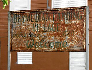
Bermudian Landing is a village in the nation of Belize, located near Scotland Halfmoon in Belize District. The name comes from the Bermuda grass planted by the early loggers to feed their oxen, who were used to drag the mahogany to the landing.

Bullet Tree Falls is a village located along the Mopan River in Cayo District, Belize. It lies approximately five kilometers northwest of San Ignacio. According to the 2010 census, Bullet Tree Falls has a population of 2,124 people in 426 households. The population consists mainly of Spanish-speaking mestizos, along with a smaller number of Maya and Creoles.
Cristo Rey is a village in the Corozal District of Belize.
Lemonal is a village in the Belize District of the central-east coastal region of Belize. Though the area was originally inhabited by Mayans this village was established in the region of Belize that was first settled by Europeans. It is one of 192 municipalities administered at the village level in the country for census taking purposes. The village had a population of 169 in 2010. This represents roughly 0.2% of the district's total population. No census record was taken for the village in 2000.
Arenal is a village in the Cayo District of central interior Belize. It is part of the Cayo West constituency. The village is in an agricultural region with the most frequent crops being citrus and banana. It is one of 192 municipalities administered at the village level in the country for census-taking purposes. The village had a population of 613 in 2010. This represents roughly 0.9% of the district's total population. This was a 29.1% increase from 475 people recorded in the 2000 census.

Cotton Tree is a village in the Cayo District of central interior Belize. The village is situated 5km to the northeast of Belmopan along the Western Highway. The surrounding area is agricultural with the most frequent crops being citrus and banana. It is one of 192 municipalities administered at the village level in the country for census taking purposes.
Cristo Rey is a village in the Cayo District of central interior Belize, situated on the east bank of the Macal River. The village is in an agricultural region with the most frequent crops being citrus and banana. It is one of 192 municipalities administered at the village level in the country for census taking purposes.
Ontario is a village in the Cayo District of central interior Belize. The village is in an agricultural region with the most frequent crops being citrus and banana. It is one of 192 municipalities administered at the village level in the country for census taking purposes.

Unitedville is a village in the Cayo District of central interior Belize. The village is in an agricultural region with the most frequent crops being citrus and banana. It is one of 192 municipalities administered at the village level in the country for census taking purposes.
References
| | This article about the geography of Belize is a stub. You can help Wikipedia by expanding it. |