
Shoreditch is an area in London, England and is located in the London Borough of Hackney alongside neighbouring parts of Tower Hamlets, which are also perceived as part of the area due to historic ecclesiastical links. Shoreditch lies just north-east of the border with the City of London and is considered to be a part of London's East End.

Liverpool Street station, also known as London Liverpool Street, is a major central London railway terminus and connected London Underground station in the north-eastern corner of the City of London, in the ward of Bishopsgate Without. It is the terminus of the West Anglia Main Line to Cambridge; the Great Eastern Main Line to Norwich; commuter trains serving east London and destinations in the East of England, including the Weaver line of the London Overground; and the Stansted Express service to Stansted Airport.

Bishopsgate was one of the eastern gates in London's former defensive wall. The gate's name is traditionally attributed to Earconwald, who was Bishop of London in the 7th century. It was first built in Roman times and marked the beginning of Ermine Street, the ancient road running from London to York (Eboracum). The gate was rebuilt twice in the 15th and 18th centuries, but was permanently demolished in 1760.

The London Wall is a defensive wall first built by the Romans around the strategically important port town of Londinium in c. AD 200, as well as the name of a modern street in the City of London, England.

Gracechurch Street is a main road in the City of London, the historic and financial centre of London, England, which is designated the A1213.
The A10 is a major road in England which runs between The City of London and King's Lynn in Norfolk.
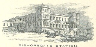
Bishopsgate was a railway station located on the eastern side of Shoreditch High Street in the parish of Bethnal Green on the western edge of the East End of London and just outside the City of London.

Hanley is one of the six towns that, along with Burslem, Longton, Fenton, Tunstall and Stoke-upon-Trent, amalgamated to form the City of Stoke-on-Trent in Staffordshire, England. The town is the main business, commercial and cultural hub of the wider Potteries area.

Bethnal Green is a station on the Weaver line of the London Overground, located in the southern part of Bethnal Green in East London. The station is 1 mile 10 chains down the line from London Liverpool Street; the next station is either Hackney Downs or Cambridge Heath. Its three-letter station code is BET and it is in Travelcard zone 2.

Edmonton is a town in north London, England within the London Borough of Enfield, a local government district of Greater London. The northern part of the town is known as Lower Edmonton or Edmonton Green, and the southern part as Upper Edmonton. Situated 8.4 miles (13.5 km) north-northeast of Charing Cross, it borders Enfield to the north, Chingford to the east, and Tottenham to the south, with Palmers Green and Winchmore Hill to the west. The population of Edmonton was 82,472 as of 2011.

Houndsditch is a street running through parts of the Portsoken and Bishopsgate Without wards of the City of London; areas which are also a part of the East End of London. The road follows the line of the outside edge of the ditch which once ran outside the London Wall. The road took its name from the section of ditch between Bishopsgate and Aldgate. The name may derive from the widespread dumping of rubbish in this stretch of ditch; relating to the dumping of dead dogs, or the scavenging of the waste by feral dogs.

Carlisle is a suburb of Perth, Western Australia. Its local government area is the Town of Victoria Park.

Shoreditch High Street is a station on the Windrush line of the London Overground, located on Bethnal Green Road in Shoreditch, East London. Situated in Travelcard Zone 1, it is located between Whitechapel and Hoxton stations. The station opened on 27 April 2010 as part of the East London line extension, replacing the nearby London Underground station at Shoreditch which closed in 2006.

St Botolph's Aldgate is a Church of England parish church in the City of London and also, as it lies outside the line of the city's former eastern walls, a part of the East End of London. The church served the ancient parish of St Botolph without Aldgate which included the extramural Portsoken Ward of the City of London, as well as East Smithfield which is outside the City.

Bishopsgate (Low Level) was a railway station opened by the Great Eastern Railway (GER) on 4 November 1872 alongside the company's first London terminus, Bishopsgate, which stood on a viaduct (and thus became also known as Bishopsgate (High Level)). The newer station was on a lower route, leading south-west, which the GER was building to its future Liverpool Street terminus and was situated on Quaker Street, on the eastern side of Shoreditch High Street (now in the London Borough of Tower Hamlets but then in the Metropolitan Borough of Bethnal Green) near Bishopsgate.

St Botolph-without-Bishopsgate is a Church of England church in the Bishopsgate Without area of the City of London, and also, by virtue of lying outside the city's eastern walls, part of London's East End.

Coleman Street is one of the 25 ancient wards of the City of London, England, and lies on the City's northern boundary with the London Borough of Islington.
St Helens or St. Helen's may refer to:

Norton Folgate was a liberty in Middlesex, England; adjacent to the City of London in what would become the East End of London.