Surveyor 7 was the seventh and last lunar lander of the American unmanned Surveyor program sent to explore the surface of the Moon. A total of 21,091 pictures were transmitted to Earth.
Surveyor 5 was the fifth lunar lander of the American unmanned Surveyor program sent to explore the surface of the Moon. Surveyor 5 landed on Mare Tranquillitatis. A total of 19,049 images were transmitted to Earth.

In physics, backscatter is the reflection of waves, particles, or signals back to the direction from which they came. It is a diffuse reflection due to scattering, as opposed to specular reflection as from a mirror. Backscattering has important applications in astronomy, photography, and medical ultrasonography. The opposite effect is forward scatter, e.g. when a translucent material like a cloud diffuses sunlight, giving soft light.

Chandrayaan-1 was India's first lunar probe. It was launched by the Indian Space Research Organisation in October 2008, and operated until August 2009. The mission included a lunar orbiter and an impactor. India launched the spacecraft using a PSLV-XL rocket, serial number C11, on 22 October 2008 at 00:52 UTC from Satish Dhawan Space Centre, at Sriharikota about 80 km (50 mi) north of Chennai. Prime Minister Atal Bihari Vajpayee announced the project on course in his Independence Day speech on 15 August 2003. The mission was a major boost to India's space program, as India researched and developed its own technology in order to explore the Moon. The vehicle was inserted into lunar orbit on 8 November 2008.

Imaging radar is an application of radar which is used to create two-dimensional images, typically of landscapes. Imaging radar provides its light to illuminate an area on the ground and take a picture at radio wavelengths. It uses an antenna and digital computer storage to record its images. In a radar image, one can see only the energy that was reflected back towards the radar antenna. The radar moves along a flight path and the area illuminated by the radar, or footprint, is moved along the surface in a swath, building the image as it does so.

The Kolchuga passive sensor is an electronic-warfare support measures system developed in the Soviet Union and manufactured in Ukraine. Its detection range is limited by line-of-sight but may be up to 800 km (500 mi) for very high altitude, very powerful emitters. Frequently referred to as Kolchuga Radar, the system is not really a radar, but an ESM system comprising three or four receivers, deployed tens of kilometres apart, which detect and track aircraft by triangulation and multilateration of their RF emissions.

Lunar water is water that is present on the Moon. Liquid water cannot persist at the Moon's surface, and water vapor is decomposed by sunlight, with hydrogen quickly lost to outer space. However, scientists have conjectured since the 1960s that water ice could survive in cold, permanently shadowed craters at the Moon's poles. Water molecules are also detected in the thin layer of gases above the lunar surface.
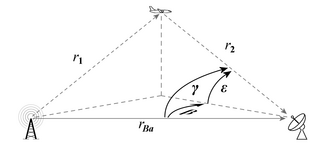
Passive radar systems encompass a class of radar systems that detect and track objects by processing reflections from non-cooperative sources of illumination in the environment, such as commercial broadcast and communications signals. It is a specific case of bistatic radar, the latter also including the exploitation of cooperative and non-cooperative radar transmitters.

Chao Meng-Fu is a 167 kilometer-diameter crater on Mercury named after the Chinese painter and calligrapher Zhao Mengfu (1254–1322). Due to its location near Mercury's south pole and the planet's small axial tilt, an estimated 40% of the crater lies in permanent shadow. This combined with bright radar echoes from the location of the crater leads scientists to suspect that it may shelter large quantities of ice protected against sublimation into the near-vacuum by the constant -171 °C temperatures.
A scatterometer or diffusionmeter is a scientific instrument to measure the return of a beam of light or radar waves scattered by diffusion in a medium such as air. Diffusionmeters using visible light are found in airports or along roads to measure horizontal visibility. Radar scatterometers use radio or microwaves to determine the normalized radar cross section of a surface. They are often mounted on weather satellites to find wind speed and direction, and are used in industries to analyze the roughness of surfaces.

SHARAD is a subsurface sounding radar embarked on the Mars Reconnaissance Orbiter (MRO) probe. It complements the MARSIS radar on Mars Express orbiter, providing lower penetration capabilities but much finer resolution.
Radar MASINT is a subdiscipline of measurement and signature intelligence (MASINT) and refers to intelligence gathering activities that bring together disparate elements that do not fit within the definitions of signals intelligence (SIGINT), imagery intelligence (IMINT), or human intelligence (HUMINT).
Geophysical MASINT is a branch of Measurement and Signature Intelligence (MASINT) that involves phenomena transmitted through the earth and manmade structures including emitted or reflected sounds, pressure waves, vibrations, and magnetic field or ionosphere disturbances.

The Lunar Reconnaissance Orbiter (LRO) is a NASA robotic spacecraft currently orbiting the Moon in an eccentric polar mapping orbit. Data collected by LRO has been described as essential for planning NASA's future human and robotic missions to the Moon. Its detailed mapping program is identifying safe landing sites, locating potential resources on the Moon, characterizing the radiation environment, and demonstrating new technologies.
Most sonar systems are monostatic, in that the transmitter and receiver are in the same place. Bistatic sonar describes when the transmitter and receiver(s) are separated by a distance large enough to be comparable to the distance to the target.

The Miniature Radio-Frequency instrument (Mini-RF) is a synthetic aperture radar (SAR) instrument on the Lunar Reconnaissance Orbiter (LRO), which is currently in orbit around the Moon. It has a resolution of 30 m/pixel and two wavelength bands, a primary band at 12.6 cm and a secondary band at 4.2 cm. The original principal investigator of Mini-RF, Stewart Nozette, was arrested for espionage. Nozette was replaced by Ben Bussey, then of APL, the Applied Physics Laboratory where Mini-RF was built. Bussey accepted a position at NASA Headquarters and was replaced by the current principal investigator, Wes Patterson, also of APL. Previous SAR instruments, such as the radar on the Magellan mission to Venus, were large, massive, power-hungry, and expensive. Intended as a demonstration of cheap, lightweight SAR technology, the Mini-RF instrument was designed in response to these concerns. Because it was a technology demonstration, Mini-RF is sometimes not included in lists of LRO's instruments.

Operation IceBridge is an ongoing NASA mission to monitor changes in polar ice. It is an airborne follow-on mission to the ICESat satellite, continuing until after the ICESat-2 mission launch in September 2018.
Beam park is a radar mode used for space surveillance, particularly tracking space debris. In beam-park mode, a radar beam is kept in a fixed direction with respect to the Earth, while objects passing through the beam are tracked. In 24 hours, as a result of the Earth’s rotation, the radar effectively scans a narrow strip through 360° of the celestial sphere. The scattered waves are detected by a receiver and the measurements obtained during the observations can be used to determine object radar cross-section, time of peak occurrence, polarization ratio, doppler shift and object rotation. The obtained information for each object is then processed and matched against data from previously catalogued objects.
The beam-park mode can be used to detect both previously known and uncatalogued objects at any altitude, provided that the reflected power captured by the receiver can be distinguished from the noise. This limits the use of radar-based beam park observations to objects in Low-Earth Orbit (LEO). Optical instruments, in turn, have very good performance for objects in Geostationary Earth Orbit (GEO) and in Geostationary Transfer Orbit (GTO). The radar technique typically outperforms optical facilities in LEO and can conduct observations for longer periods, both during day and night, independently of the weather and object illumination by sunlight.
Sugar Tree is the name of a bistatic radar Over-the-horizon radar built by the US in the 1960s. The key idea in Sugar Tree was a reinvention of Klein Heidelberg Nazi German radar system developed for use in the Second World War. Sugar Tree was a "covert hitchhiker using Soviet, surface-wave HF radio broadcast signals and a remote sky-wave receiver to detect Soviet ballistic missile launches". The key idea, in other words, is to receive radar reflexions without oneself transmitting a radar signal by using instead some other signal, typically one that originates from the adversary.