
Heanton Punchardon ( ) is a village, civil parish and former manor, anciently part of Braunton Hundred. It is situated directly east-southeast of the village of Braunton, in North Devon. The parish lies on the north bank of the estuary of the River Taw and it is surrounded, clockwise from the north, by the parishes of Braunton, Marwood, Ashford and across the estuary, Fremington. The population was 418 in 1801 and 404 in 1901. Its largest localities are Wrafton and Chivenor. The surrounding area is also an electoral ward with a total population at the 2011 census of 2,673.
St Giles in the Wood is a village and civil parish in the Torridge district of Devon, England. The village lies about 2.5 miles east of the town of Great Torrington, and the parish, which had a population of 566 in 2001 compared with 623 in 1901, is surrounded clockwise from the north by the parishes of Huntshaw, Yarnscombe, High Bickington, Roborough, Beaford, Little Torrington and Great Torrington. Most of the Victorian terraced cottages in the village, on the east side of the church, were built by the Rolle Estate.

Meavy is a small village, civil parish and former manor in the English county of Devon. Meavy forms part of the district of West Devon. It lies a mile or so east of Yelverton. The River Meavy runs near the village. For administrative purposes the parish is grouped with the parishes of Sheepstor and Walkhampton to form Burrator Parish Council, and for electoral purposes it is grouped with the same two parishes to form Burrator Ward.

Umberleigh is a former large manor within the historic hundred of (North) Tawton, but today a small village in North Devon in England. It used to be an ecclesiastical parish, but following the building of the church at Atherington it became a part of that parish. It forms however a part of the civil parish of Chittlehampton, which is mostly located on the east side of the River Taw.
Halsbury is a historic manor in the parish of Parkham in North Devon, England. It is situated 2 miles north-east of the village of Parkham and 4 miles south-west of the town of Bideford. Halsbury was long a seat of the ancient Giffard family, a distant descendant of which was the celebrated lawyer Hardinge Stanley Giffard, 1st Earl of Halsbury (1823–1921), who adopted the name Halsbury for his earldom and was the author of the essential legal reference books Halsbury's Statutes. Halsbury Barton, now a farmhouse, retains 16th- and 17th-century elements of the former manor house of the Giffard family. It was described in a record of 1560 as a "new dwelling house".

Ashbury is a village and former civil parish, now in the parish of Northlew, in the West Devon district, in the county of Devon, England. It is 5 miles (8 km) south-west of Hatherleigh. Its population is 65.
Brixton is a village, parish and former manor situated near Plymouth in South Hams, Devon, England. It is located on the A379 Plymouth to Kingsbridge road and is about 6 miles (9.7 km) from Plymouth. Its population is 1207. The parish contains the former manors of Brixton Reigny and Brixton English.

Goodleigh is a village, civil parish and former manor in North Devon, England. The village lies about 2+1⁄2 miles (4 km) north-east of the historic centre of Barnstaple. Apart from one adjunct at the south, it is generally a linear settlement.

Swimbridge is a village, parish and former manor in Devon, England. It is situated 4 miles (6.4 km) south-east of Barnstaple and twinned with the town of St.Honorine Du Fay in Normandy, France. It was the home of the Rev. John "Jack" Russell who first bred the Jack Russell Terrier.

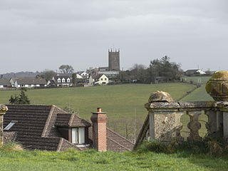
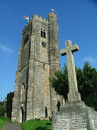
Shirwell is a village, civil parish and former manor in the local government district of North Devon, in the county of Devon, England. It was also formerly the name of a hundred of Devon. The village lies about 3.5 miles north-east of the town of Barnstaple, to the east of the A39 road to Lynton. The parish is surrounded clockwise from the north by the parishes of East Down, Arlington, Loxhore, Bratton Fleming, Goodleigh, Barnstaple, West Pilton and Marwood. In 2001 its population was 333, little changed from the 1901 figure of 338.

Hall is a large estate within the parish and former manor of Bishop's Tawton, Devon. It was for several centuries the seat of a younger branch of the prominent and ancient North Devon family of Chichester of Raleigh, near Barnstaple. The mansion house is situated about 2 miles south-east of the village of Bishop's Tawton and 4 miles south-east of Barnstaple, and sits on a south facing slope of the valley of the River Taw, overlooking the river towards the village of Atherington. The house and about 2,500 acres of surrounding land continues today to be owned and occupied by descendants, via a female line, of the Chichester family. The present Grade II* listed neo-Jacobean house was built by Robert Chichester between 1844 and 1847 and replaced an earlier building. Near the house to the south at the crossroads of Herner the Chichester family erected in the 1880s a private chapel of ease which contains mediaeval woodwork saved from the demolished Old Guildhall in Barnstaple.
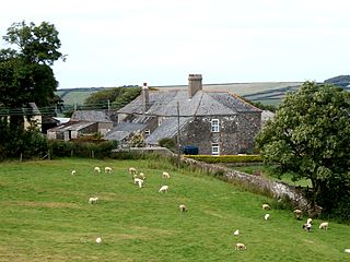
The Manor of Shirwell was a manor in North Devon, England, centred on the village of Shirwell and largely co-terminous with the parish of Shirwell. It was for many centuries successively the seat of two of the leading families of North Devon, the Beaumonts and their heirs the Chichesters of Raleigh, Pilton, both of which families were seated at the estate of Youlston within the manor of Shirwell. The manor house which survives today known as Youlston Park is one of the most architecturally important historic houses in North Devon and exists largely in its Georgian form, but retains many impressive late 17th-century interiors.

The estate of Acland in the parish of Landkey, near Barnstaple in North Devon, England, was from 1155 the earliest known seat of the influential and wealthy family of Acland, to which it gave the surname de Acland. It is situated about 3/4 mile north-east of the village of Landkey, from which it is now cut off by the busy A361 North Devon Link Road.

Yeotown was a historic estate situated in the parish of Goodleigh, North Devon, about 1 1/2 miles north-east of the historic centre of Barnstaple. The mansion house was remodelled in about 1807 in the neo-gothic style by Robert Newton Incledon (1761-1846), eldest son of Benjamin Incledon (1730-1796) of Pilton House, Pilton, near Barnstaple, an antiquarian and genealogist and Recorder of the Borough of Barnstaple (1758–1796). It was demolished during his lifetime and today only one of the large gatehouse survives, since converted into a farmhouse known as Ivy Lodge. The surviving drawing of the house in the collection of the North Devon Athaneum in Barnstaple shows a large chapel, or small church, with a tall square three-storied pinnacled tower attached to the house.

Richard Acland (1679–1729), lord of the Manor of Fremington, near Barnstaple in North Devon, was a Member of Parliament for Barnstaple 1708–13.

Wembworthy is a small village, parish and former manor in Mid-Devon, England. It is situated in the valley of the River Taw, 8 miles north-east of the towns of Hatherleigh and 12 miles south of South Molton. St Michael's Church is the parish church, much rebuilt in the 1840s. The vestigial remnants of two mediaeval earthwork castles survive within the parish, one in Heywood Wood, of motte and bailey form, the other to its south of ringwork and bailey form.

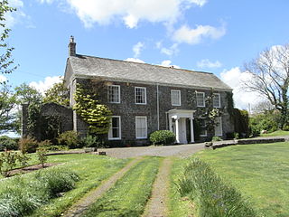
Hawkridge in the parish of Chittlehampton in North Devon, England, is an historic estate, anciently the seat of a junior branch of the Acland family which originated at nearby Acland, in the parish of Landkey and later achieved great wealth and prominence as the Acland Baronets of Killerton, near Exeter. The former mansion house is today a farmhouse known as Hawkridge Barton, a grade II* listed building. The Devon historian Hoskins (1959) stated of Hawkridge: "Externally there is nothing remarkable except a decaying avenue of ancient walnuts, so often the first indication of a 16th or 17th century mansion". The interior contains a fine plaster heraldic overmantel showing the arms of Acland impaling Tremayne, representing the 1615 marriage of Baldwin Acland (1593–1659) of Hawkridge and Elizabeth Tremayne.
Thuborough in the parish of Sutcombe, Devon, England, is an historic estate, formerly a seat of a branch of the Prideaux family, also seated at Orcharton, Modbury; Adeston, Holbeton; Soldon, Holsworthy; Netherton, Farway; Ashburton; Nutwell, Woodbury; Ford Abbey, Thorncombe, all in Devon and at Prideaux Place, Padstow and Prideaux Castle, Luxulyan, in Cornwall. The present mansion house, comprising "Thuborough House" and "Thuborough Barton", the north-east block, is a grade II listed building.

North Huish is a village, civil parish, former ecclesiastical parish and former manor in the South Hams district of Devon, England. The village is situated about 8 miles south-west of the town of Totnes. Avonwick is the largest village in the parish, Avonwick was only named that in 1870 and parts were previously part of different parishes until the late 20th century. The parish had a population of 360 in the 2001 census.

Spridleston is an historic manor in the parish of Brixton in Devon, England, long a seat of a branch of the prominent and widespread Fortescue family. The ancient manor house does not survive, but it is believed to have occupied the site of the present Spriddlestone Barton, a small Georgian stuccoed house a few hundred yards from the larger Spriddlestone House, also a Georgian stuccoed house, both centred on the hamlet of Spriddlestone and near Higher Spriddlestone Farm.
