The Centre Georges-Vézina, formerly the Colisée de Chicoutimi, is a 4,724 capacity multi-purpose arena in Saguenay, Quebec, Canada. The arena was built in 1949 and features an Olympic-sized ice pad of 200' X 100'.
Dababa is one of three departments in Hadjer-Lamis, a region of Chad. Its capital is Bokoro.

Grenada National Stadium is a multi-purpose stadium in St. George's, Grenada. It is currently used mostly for football matches. The stadium holds 8,000 people.
Five Forks is an unincorporated community in Gwinnett County in the U.S. state of Georgia near the intersections of River Road, Five Forks Trickum, Oak Road and Dogwood Road. It is a former mail-stop served from the mid-1800s to early 1900s by the Yellow River Post Office and still appears on maps as a small unincorporated community between Snellville and Lawrenceville. It is connected to another nearby mail-stop called Trickum by the unusually named Five Forks Trickum Road. Currently, the center of Five Forks is home to some restaurants and shopping centers, as well as relatively new Ronald Reagan Park across the street from the Five Forks Library branch.

CION-FM is a French-language Canadian radio station located in Quebec City, Quebec.
Tilden is an unincorporated community in Middle Township, Hendricks County, Indiana.

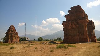
Thuận Bắc is a district (huyện) of Ninh Thuận province in the Southeast region of Vietnam.
Oakland Park is an unincorporated community in Northampton County, Virginia, United States.
Qaravuldaş is a village in the Yardymli Rayon of Azerbaijan. The village forms part of the municipality of Avaş.
Hopewell is an unincorporated community in Leon County, Texas, United States. It lies at an elevation of 410 feet (120 m).
Oak Row is an unincorporated community in Richmond County, in the U.S. state of Virginia.
Gluhavica is a village in the municipality of Tutin, Serbia. According to the 2002 census, the village has a population of 265 people.
Riljac is a village in the municipality of Trstenik, Serbia. According to the 2002 census, the village has a population of 730 people.
Smith or Smiths Turnout is an unincorporated community in southern York County, South Carolina located south of Rock Hill and northwest of Edgemoor near the Chester County line. The elevation of Smith is 531 feet.
Warren is an unincorporated community in Carbon County, Montana, United States at 45°03′36″N108°39′30″W, elevation 4,419 feet (1,347 m). It is situated on Montana Secondary Highway 310.

Baijiahu station, named after Baijia Lake nearby to the northwest, is a station of Line 1 of the Nanjing Metro. It began operations on 28 May 2010, as part of the southern extension of line 1 from Andemen to CPU.
Hilton is an unincorporated community located in Howard County in the state of Maryland, United States.
New Hope is an unincorporated community in the southeast corner of Franklin Township, Owen County, in the U.S. state of Indiana. It lies near the intersection of County Road 740 South and County Road 285 West, which is a community about nine miles southwest of the city of Spencer, the county seat. Its elevation is 522 feet, and it is located at 39°10′59″N86°49′40″W.
Kurreville is an unincorporated community in Cape Girardeau County, in the U.S. state of Missouri.
Henderson is an unincorporated community in Webster County, in the U.S. state of Missouri.


