This is a list of the extreme points of the United Kingdom: the points that are farther north, south, east or west than any other location. Traditionally the extent of the island of Great Britain has stretched "from Land's End to John o' Groats".

This is a list of the extreme points of Ireland – the points that are furthest north, south, east or west in Ireland. It includes the Republic of Ireland and Northern Ireland.
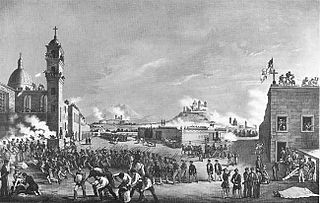
Following the Battle of Chapultepec, Santa Anna withdrew his forces from Mexico City, leading a portion in an attempt to take Puebla and cut off Scott's supply route from Veracruz. The siege of Puebla began the same day Mexico City fell to Winfield Scott and lasted for 28 days before a relief force fought its way into the city.

The Skagit Valley lies in the northwestern corner of the state of Washington, United States. Its defining feature is the Skagit River, which snakes through local communities which include the seat of Skagit County, Mount Vernon, as well as Sedro-Woolley, Concrete, Lyman-Hamilton, and Burlington.

San Miguelito is a city and district (distrito) of Panamá Province in Panama. The population according to the 2000 census was 293,745; the latest official estimate is 375,409. The district covers an area of 50.1 km². San Miguelito district is completely enclaved within Panama District and it is included in the Panama City Metropolitan Area.
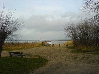
Langenwerder is a small uninhabited island near the island Poel north of Gollwitz, a district of the municipality of Poel island.

Villalobón is a municipality located in the province of Palencia, Castile and León, Spain. According to the 2004 census (INE), the municipality has a population of 608 inhabitants.

Santed is a municipality located in the province of Zaragoza, Aragon, Spain. According to the 2004 census (INE), the municipality has a population of 75 inhabitants.

Villacarralón is a municipality located in the province of Valladolid, Castile and León, Spain. According to the 2004 census (INE), the municipality has a population of 89 inhabitants.
Kinh Môn is a town of Hải Dương Province in the Red River Delta region of Vietnam. As of 2003 the district had a population of 164,956. The district covers an area of 163 km². The district capital lies at An Lưu.

Tenkodogo is a department or commune of Boulgou Province in eastern Burkina Faso. Its capital is the town of Tenkodogo. According to the 2019 census the department has a total population of 157,947.
Kokoun is a village in north-western Ivory Coast. It is in the sub-prefecture of Madinani, Madinani Department, Kabadougou Region, Denguélé District.
Madina-Wora is a town and sub-prefecture in the Mali Prefecture in the Labé Region of northern Guinea. It is listed under Geocode 2608 and Has code GN.ML.MW. It is a third-order administrative division.
SS Norlantic was an American cargo ship of the Norlasco Steamship Company of New York that was scuttled after being damaged by U-69 in May 1942 with the loss of seven lives. The ship was built as SS Lake Fandango, a design 1099 ship of the United States Shipping Board (USSB), in 1919 and had also sailed under the name SS Lexington.
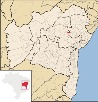
São José do Jacuípe is a municipality in the state of Bahia in the North-East region of Brazil.

Chichiquila Municipality is a municipality in the Mexican state of Puebla in south-eastern Mexico.

Nevade is a village in the municipality of Gornji Milanovac, Serbia. At the 2011 census, the village had a population of 627 people.
Assin Kyekyewere is a small town and is the district capital of Assin South district in the Central Region of Ghana. Due to its proximity to Assin Nsuaem, it is often mistaken to be part of the same town.
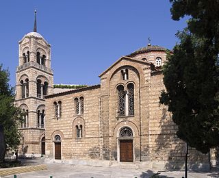
The Church of the Holy Trinity is a Byzantine-era church at Filellinon Street that serves the Russian Orthodox community of Athens, Greece.

