Black Mallard River

Last updated
Black Mallard River
Country United States
Physical characteristics
Main source Bearinger Township, Presque Isle County, Michigan
River mouth Lake Huron
581 ft (177 m)
Length 10 mi (16 km)

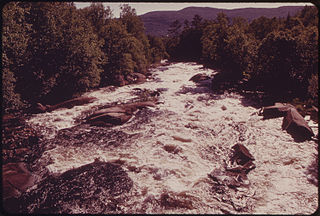
The Black Mallard River, also known as Carp Creek, is a short river in the Lower Peninsula of the U.S. state of Michigan. The river is approximately 10 miles (16 km) long [1] and flows into Lake Huron about 15 miles (24 km) east of Cheboygan at 45°32′24″N84°07′51″W / 45.54000°N 84.13083°W / 45.54000; -84.13083 . [2]

River Natural flowing watercourse

A river is a natural flowing watercourse, usually freshwater, flowing towards an ocean, sea, lake or another river. In some cases a river flows into the ground and becomes dry at the end of its course without reaching another body of water. Small rivers can be referred to using names such as stream, creek, brook, rivulet, and rill. There are no official definitions for the generic term river as applied to geographic features, although in some countries or communities a stream is defined by its size. Many names for small rivers are specific to geographic location; examples are "run" in some parts of the United States, "burn" in Scotland and northeast England, and "beck" in northern England. Sometimes a river is defined as being larger than a creek, but not always: the language is vague.

Lower Peninsula of Michigan Michigan in the United States

The Lower Peninsula of Michigan is the southern of the two major landmasses of the U.S. state of Michigan, the other being the Upper Peninsula. It is surrounded by water on all sides except its southern border, which it shares with Indiana and Ohio. Although the Upper Peninsula is commonly referred to as "the U.P." it is fairly uncommon for the Lower Peninsula to be called "the L.P."

U.S. state constituent political entity of the United States

In the United States, a state is a constituent political entity, of which there are currently 50. Bound together in a political union, each state holds governmental jurisdiction over a separate and defined geographic territory and shares its sovereignty with the federal government. Due to this shared sovereignty, Americans are citizens both of the federal republic and of the state in which they reside. State citizenship and residency are flexible, and no government approval is required to move between states, except for persons restricted by certain types of court orders. Four states use the term commonwealth rather than state in their full official names.

The Black Mallard rises in Bearinger Township in northwest Presque Isle County and flows mostly east and south into Black Mallard Lake about a mile inland from Lake Huron. Its entire length lies within Bearinger Township. 100% of the frontage is privately owned. Depth varies from 6 inches to 6 feet. Width varies from 12 to 22 feet. Numerous tree falls and beaver dams.

Bearinger Township, Michigan Township in Michigan, United States

Bearinger Township is a civil township of Presque Isle County in the U.S. state of Michigan. As of the 2010 census, the township population was 369.

Presque Isle County, Michigan County in the United States

Presque Isle County is a county in the Lower peninsula of the U.S. state of Michigan. As of the 2010 United States Census, the population was 13,376. The county seat is Rogers City. The county was authorized by state legislative action on April 1, 1840, but the county government was not established until 1871. The government was reorganized in 1875.

The Black Mallard River also hosts nice rainbow trout, and smallmouth bass fishing and a large number of rock bass as well.

Rainbow trout species of trout

The rainbow trout is a trout and species of salmonid native to cold-water tributaries of the Pacific Ocean in Asia and North America. The steelhead is an anadromous (sea-run) form of the coastal rainbow trout(O. m. irideus) or Columbia River redband trout (O. m. gairdneri) that usually returns to fresh water to spawn after living two to three years in the ocean. Freshwater forms that have been introduced into the Great Lakes and migrate into tributaries to spawn are also called steelhead.

Smallmouth bass species of fish

The smallmouth bass is a species of freshwater fish in the sunfish family (Centrarchidae) of the order Perciformes. It is the type species of its genus. One of the black basses, it is a popular game fish sought by anglers throughout the temperate zones of North America, and has been spread by stocking—as well as illegal introductions—to many cool-water tributaries and lakes in Canada and more so introduced in the United States. The maximum recorded size is approximately 27 inches and 12 pounds. The smallmouth bass is native to the upper and middle Mississippi River basin, the Saint Lawrence River–Great Lakes system, and up into the Hudson Bay basin. Its common names include smallmouth, bronzeback, brown bass, brownie, smallie, bronze bass, and bareback bass.

Fishing activity of trying to catch fish

Fishing is the activity of trying to catch fish. Fish are normally caught in the wild. Techniques for catching fish include hand gathering, spearing, netting, angling and trapping. “Fishing” may include catching aquatic animals other than fish, such as molluscs, cephalopods, crustaceans, and echinoderms. The term is not normally applied to catching farmed fish, or to aquatic mammals, such as whales where the term whaling is more appropriate. In addition to being caught to be eaten, fish are caught as recreational pastimes. Fishing tournaments are held, and caught fish are sometimes kept as preserved or living trophies. When bioblitzes occur, fish are typically caught, identified, and then released.

Related Research Articles

Au Sable River (Michigan) river in Michigan

The Au Sable River in Michigan, United States runs approximately 138 miles (222 km) through the northern Lower Peninsula, through the towns of Grayling and Mio, and enters Lake Huron at Au Sable. It is considered one of the best brown trout fisheries east of the Rockies and has been designated a blue ribbon trout stream by the Michigan Department of Natural Resources. In French, au sable literally means "at the sand." A 1795 map calls it the Beauais River.

Alcona Township, Michigan Civil township in Michigan, United States

Alcona Township is a civil township of Alcona County in the U.S. state of Michigan. As of the 2010 census, the township population was 968.

Clarence Township, Michigan Township in Michigan, United States

Clarence Township is a civil township located in northeast Calhoun County in the U.S. state of Michigan. It is part of the Battle Creek, Michigan Metropolitan Statistical Area. The population was 1,985 at the 2010 census. The township was originally named Pinkney Township.

Huron River (Michigan) river flowing to Lake Erie in southeast Michigan

The Huron River is a 130-mile-long (210 km) river in southeastern Michigan, rising out of the Huron Swamp in Springfield Township in northern Oakland County and flowing into Lake Erie on the boundary between Wayne County and Monroe County. In addition to thirteen parks, game areas, and recreation areas, the river passes through the cities of Dexter, Ann Arbor, Ypsilanti, Belleville, Flat Rock and Rockwood.

Bear River (Michigan) small clear slow moving river in the U.S. state of Michigan

Bear River is a small clear slow-moving river in the U.S. state of Michigan. 14.7 miles (23.7 km) long, it is the largest tributary of Little Traverse Bay in the northwest of the lower peninsula. Traverse Bay is on Lake Michigan. The river is formed as the outflow of Walloon Lake on the boundary between Charlevoix County and Emmet County, draining from the southeast end of the lake at 45°15′40″N84°56′01″W near the community of Walloon Lake in Melrose Township. M-75 has its northern terminus in a junction with US 131 nearby.

The Pinnebog River is a 39.4-mile-long (63.4 km) river in the Thumb region of the U.S. state of Michigan. The river flows into Lake Huron on the west side of the "tip" of the "thumb".

Cass River (Michigan) river in the United States of America

The Cass River is a 61.5-mile-long (99.0 km) river in the Thumb region of the U.S. state of Michigan. It drains large portions of Sanilac and Tuscola counties and smaller portions of Genesee, Huron, Lapeer, and Saginaw counties.

Carp River is a 40.2-mile-long (64.7 km) river in Chippewa and Mackinac counties in the U.S. state of Michigan. 21.7 miles (34.9 km) of the river were added to the National Wild and Scenic Rivers System in 1992.

Black River (Wisconsin) tributary of the Mississippi River near La Crosse, Wisconsin

The Black River is a river in west-central Wisconsin and tributary of the Mississippi River. The river is approximately 190 miles (310 km) long. During the 19th century, pine logs were rafted down the Black, heading for sawmills at La Crosse and points beyond.

Black River is a 15.5-mile-long (24.9 km) river in Alcona County in the U.S. state of Michigan. The main branch rises in northern Harrisville Township at 44°40′46″N83°22′15″W and flows north through Haynes Township and Alcona Township and empties into Lake Huron at 44°48′58″N83°17′57″W at the unincorporated community of Black River.

Black River (Ohio) river in Ohio, United States

The Black River is a tributary of Lake Erie, about 12 mi (19 km) long, in northern Ohio in the United States. Via Lake Erie, the Niagara River and Lake Ontario, it is part of the watershed of the St. Lawrence River, which flows to the Atlantic Ocean. The Black drains an area of 470 mi² (1217 km²).

Magalloway River river in the United States of America

The Magalloway River is a river in northwestern Maine and northern New Hampshire in the United States. It is a tributary of the Androscoggin River, which flows to the Kennebec River at Merrymeeting Bay in Maine, near the Atlantic Ocean. The total length of the river is 30 miles (48 km), or 48 miles (77 km) if the distances across intervening lakes are included.

Cheboygan River

The Cheboygan River is a short but significant river in the Lake Huron drainage basin of the U.S. state of Michigan.

Ocqueoc River river in the United States of America

The Ocqueoc River is stream in Presque Isle County in the northeastern part of the lower peninsula in the U.S. state of Michigan. It is 34.2 miles (55.0 km) long and encompasses a watershed of approximately 94,394 acres (382.00 km2).

Saganing River river in the United States of America

The Saganing River, also known as Saganing Creek, is a 10.0-mile-long (16.1 km) stream in the U.S. state of Michigan.

The Little Black River is a 6.1-mile-long (9.8 km) stream in Cheboygan County in the U.S. state of Michigan. It rises in Beaugrand Township at 45°40′28″N84°35′48″W and flows eastward into Lake Huron in the city of Cheboygan at 45°39′47″N84°29′21″W, less than a mile west of the mouth of the Cheboygan River.

Sturgeon River (Cheboygan County, Michigan) river in the U.S. state of Michigan, flowing mostly northward through Otsego and Cheboygan counties

Sturgeon River is a 40.8-mile-long (65.7 km) river in the U.S. state of Michigan, flowing mostly northward through Otsego and Cheboygan counties.

Indian River (Mullett Lake) river in the United States of America

Indian River in the Lower Peninsula of Michigan is a 3.9-mile-long (6.3 km) waterway in Cheboygan County that flows from Burt Lake at 45°24′37″N84°37′19″W to Mullett Lake at 45°27′05″N84°34′39″W. The unincorporated community of Indian River is named after the river.

The Little Pigeon River is a 10.2-mile-long (16.4 km) stream in Otsego and Cheboygan counties in the U.S. state of Michigan.

Bell River is a short river in Presque Isle County in the U.S. state of Michigan.

References

  1. U.S. Geological Survey. National Hydrography Dataset high-resolution flowline data. The National Map Archived 2012-04-05 at WebCite , accessed November 21, 2011
  2. U.S. Geological Survey Geographic Names Information System: Black Mallard River