Related Research Articles

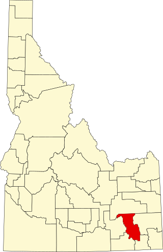
Power County is a county located in the U.S. state of Idaho. As of the 2020 Census, the county had a population of 7,878. The county seat and largest city is American Falls. The county was created by the Idaho Legislature on January 30, 1913, by a partition of Cassia County. It is named for an early hydroelectric power plant (1902) at the American Falls.
Bannock County is a county in the southeastern part of Idaho. As of the 2020 Census, the population was 87,018, making it the sixth-most populous county in Idaho. The county seat and largest city is Pocatello. The county was established in 1893 and named after the local Bannock tribe. It is one of the counties with territories included in the Fort Hall Indian Reservation of the federally recognized Shoshone-Bannock Tribes.

Chubbuck is a city in Bannock County, Idaho. It is part of the Pocatello Metropolitan Statistical Area. The population was 13,922 at the 2010 census. Chubbuck is located immediately north of Pocatello, Idaho, and has opposed several consolidation proposals since the 1960s.
American Falls is a city in and the county seat of Power County, Idaho. The population was 4,457 at the time of the 2010 census.
Edmonton is a home rule-class city in and the county seat of Metcalfe County, Kentucky, United States. It is part of the Glasgow Micropolitan Statistical Area. The population was 1,671 at the 2020 census.

The Pine Ridge is an escarpment between the Niobrara River and the White River in far northwestern Nebraska. The high tableland between the rivers has been eroded into a region of forested buttes, ridges and canyons.
The Mogollon Plateau or Mogollon Mesa is a pine-covered southern plateau section of the larger Colorado Plateau in east-central Arizona and west-central New Mexico, United States. The southern boundary of the plateau is the Mogollon Rim. The Mogollon Plateau is 7,000–8,000 feet (2,100–2,400 m) high. The plateau lends its name to the Mogollon tribe, part of the Cochise-Mogollan peoples who inhabited this and nearby areas from 5,000 to 2,500 years ago. Their descendants are believed to include the Anasazi.
There are several lakes named Mud Lake within the U.S. state of Idaho.

The Idaho Department of Correction (IDOC) operates nine prisons, four community release centers and 20 probation and parole offices in seven districts located throughout the state of Idaho. The agency has its headquarters in Boise.

Paige is an unincorporated community in Caroline County, in the U.S. state of Virginia.

The Black Pine Mountains are a mountain range in the U.S. states of Idaho (~65%) and Utah (~35%), spanning Cassia County, Idaho and reaching into Box Elder County, Utah. The highest point in the range is known as Black Pine Mountains High Point, sometimes referred to as Black Peak, at 9,395 feet (2,864 m), and the range is a part of the Great Basin Divide and the Basin and Range Province. In Idaho, the mountains are part of the Black Pine Division of the Minidoka Ranger District of Sawtooth National Forest.

Clarence is a hamlet and census-designated place (CDP) within the town of Clarence in Erie County, New York, United States. The population was 2,646 at the 2010 census.

Pine Ridge Mall is an enclosed shopping mall located in Chubbuck, Idaho, near Interstate 86. The mall was developed by Price Development Corporation and opened in 1981. The mall is currently owned by Farmer Holding Co. and the anchor tenants are C-A-L Ranch Stores, Gem Prep, Hobby Lobby, JCPenney, and Planet Fitness.
Dirty Head is a summit in Franklin County, Idaho and Cache County, Utah, in the United States. With an elevation of 5,236 feet (1,596 m), Dirty Head is the 1933rd highest summit in the state of Idaho.
Woodville is an unincorporated community in Bingham County, in the U.S. state of Idaho.
Hawkins is an unincorporated community in Bannock County, in the U.S. state of Idaho.

Mount Putnam is a summit in the U.S. state of Idaho, with an elevation of 8,809 feet (2,685 m).
Galls Creek is a stream in the U.S. state of Oregon. It is a tributary to the Rogue River.
References
Municipalities and communities of Oneida County, Idaho, United States | ||
|---|---|---|
| City |  | |
| Unincorporated communities | ||
| Ghost town | ||
42°04′21″N112°58′49″W / 42.07250°N 112.98028°W
| | This Oneida County, Idaho state location article is a stub. You can help Wikipedia by expanding it. |