History
In the late 1880s residents jokingly referred to the street as Blackstone after the English legal scholar William Blackstone, due to the number of lawyers living there. [3]
The local history may be best recorded by some of the old surviving homes on Blackstone Avenue which are in the Register of National Historic Places, including the Ella Hoxie Home (251 N. Blackstone Avenue); Brix Home (313 N. Blackstone Avenue); Griffen Home (319 N. Blackstone Avenue); Hines Home (333 N. Blackstone Avenue). Earth Metrics Inc. performed an analysis of historic aerial photographs in the Blackstone Avenue vicinity. [4] In 1946, the area contained many residences on large lots. [5] The photographs observed indicate that many of these large lots included row crops. Surrounding lands at that time were predominantly used for agriculture, with orchards lining much of the western side of Blackstone Avenue. A mixture of row crops, vacant fields, orchards, and scattered residences made up much of the landscape on the eastern side of Blackstone Avenue.
The aerial photographs taken in 1962 indicate that land use in the subject site vicinity showed significant change between 1946 and 1962. Urbanization occurred in the Blackstone Avenue vicinity during this period. Orchards and row crops had been largely replaced by commercial and residential structures by 1962.

Sutter's Fort was a 19th-century agricultural and trade colony in the Mexican Alta California province. The site of the fort was established in 1839 and originally called New Helvetia by its builder John Sutter, though construction of the fort proper wouldn't begin until 1841. The fort was the first non-Indigenous community in the California Central Valley. The fort is famous for its association with the Donner Party, the California Gold Rush, and the formation of the city of Sacramento, surrounding the fort. It is notable for its proximity to the end of the California Trail and Siskiyou Trails, which it served as a waystation.
Fresno is a city in and the county seat of Fresno County, California, United States. It covers about 112 square miles (290 km2) in the center of the San Joaquin Valley, the southern portion of California's Central Valley.

Michigan Avenue is a north-south street in Chicago which runs at 100 east on the Chicago grid. The northern end of the street is at Lake Shore Drive on the shore of Lake Michigan in the Gold Coast Historic District. The street's southern terminus is at Sibley Boulevard in the southern suburb of Harvey, though like many Chicago streets it exists in several disjointed segments.

Olney is a neighborhood in North Philadelphia, Pennsylvania, United States. It is roughly bounded by Roosevelt Boulevard to the south, Tacony Creek to the east, Godfrey Avenue to the north, and the railroad right-of-way west of Seventh Street to the west.
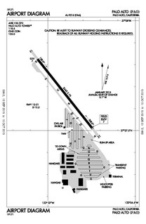
Palo Alto Airport is a general aviation airport in the city of Palo Alto in Santa Clara County, California, United States, near the south end of San Francisco Bay on the western shore.

The Fresno Area Express (FAX), is a public transportation operator in Fresno, California. The line has over 100 buses, 1,606 bus stations, and 16 fixed routes as of December 2013. FAX offers free transfers as well as wheelchair lifts and bike racks on all buses.

Temescal Creek is one of the principal watercourses in the city of Oakland, California, United States.

Lafayette Square is a neighborhood in St. Louis, Missouri, which is bounded on the north by Chouteau Avenue, on the south by Interstate 44, on the east by Truman Parkway, and on the west by South Jefferson Avenue. It surrounds Lafayette Park, which is the city's oldest public park — created by local ordinance in 1836.

Ardenwood Historic Farm is a Regional Historic Landmark in Fremont, California. It is managed by the East Bay Regional Park District. The Ardenwood Historic Farm consists of the Ardenwood Station, the former Ohlone village and burial site, a blacksmith shop, an area with farm animals, Patterson House, and a gazebo. The Ardenwood Farm today is a working farm, producing grain and vegetables.

Zamora is an unincorporated community in rural Yolo County, California, U.S., on Interstate 5 due west of Knights Landing. Its ZIP code is 95698 and its area code 530. It is in the northern part of the county. "Zamora District is bordered by County Road 10 to the north and County Road 16 to the south, County Road 85 on the west and Highway 113 on the east. In 1879 Zamora District included the areas of West Grafton,the eastern portion of Fairview and a small strip of East grafton. The Zamora District encompasses Oat Valley, along Oat Creek in the northwestern part of the district and Hungry Hollow which is in an area along the foothills west of Zamora."

Bardsdale is a rural unincorporated community and populated place in Ventura County, California. It is located in the orange blossom and agricultural belt of the Santa Clara River Valley, south of the Santa Clara River and on the north slope of South Mountain. The closest town is Fillmore, which is on the north side of the Santa Clara about 3 miles (5 km) from Bardsdale. Santa Paula is about 7 miles (11 km) west, the most direct route being South Mountain Road. Moorpark is about 6 miles (10 km) south over the serpentine mountain road known as Grimes Canyon.

Pinedale is a previously unincorporated community in Fresno County, California. It lies at an elevation of 348 feet. It was once a rural community located on the Southern Pacific Railroad 3.5 miles (5.6 km) north-northwest of Clovis but has since become surrounded and annexed by the city of Fresno. Millerton Lake State Recreational Area is to its NE. The ZIP Code is 93650, and the community is inside area code 559.

Dufferin Grove is a neighbourhood located in Toronto, Ontario, Canada, west of downtown. The neighbourhood is bordered by Bloor Street West to the north, Ossington Ave to the east, College Street to the south, and Dufferin Street to the west.

Cutting Boulevard is a major east-west arterial trunk road in the city of Richmond, California.

Princeton-by-the-Sea is an unincorporated community on the coast of San Mateo County, California. The ZIP code is 94019 and the community is inside area code 650.

Castor Gardens is a neighborhood in the lower Northeast section of Philadelphia, Pennsylvania, United States. Castor Gardens' borders are ill-defined, but it exists in the vicinity of Castor Avenue and Cottman Avenue. It is also near Roosevelt Boulevard. The neighborhood can either be entered from the south, by taking the Oxford Circle exit of Roosevelt Boulevard, or from the north, by taking the Cottman Avenue exit. Adjacent neighborhoods are Mayfair, Lawndale, Burholme, Oxford Circle, and Rhawnhurst.
Schoonmaker Point is a low-lying landform jutting into San Francisco Bay at Sausalito, California. This area was created by dredge spoils from Richardson Bay during local Marin Shipyards shipbuilding activity during World War II. Schoonmaker Point is situated approximately 1.7 miles (2.7 km) south of the Sausalito/Marin City interchange of U.S. Highway 101 immediately north of Bridgeway Boulevard. The Schoonmaker Point Marina is located here, along with a 2.3-acre (9,300 m2) sand beach.. From Schoonmaker Point there are views of Mount Tamalpais and the San Francisco downtown skyline.
The Junipero Serra Landfill was a solid waste disposal site in Colma, California, United States. The site was closed in 1983 and ultimately developed by commercial land uses, collectively known as the Metro Center. The original commercial use built on the closed landfill site was a Home Depot Inc.retail store and parking lot constructed over 1,348 piles, each driven approximately 160 ft (49 m) deep into the landfill. The site also required the engineering of a landfill gas control system, since, when organic solid waste aerobically decomposes, it produces methane gas, which is explosive and toxic in large concentrations. SCS Engineers was presented an award by the Solid Waste Association of North America for the design of the closure methane capture system at this landfill..

The Tower Theatre for the Performing Arts is a historic Streamline Moderne mixed-use theater in Fresno, California. Built in 1939, it opened to the public on December 15, 1939, under the management of Fox West Coast Theater Corporation. The building was designed by S. Charles Lee, with its tower inspired by the "Star Pylon" at the 1939 New York World's Fair. The theater underwent a renovation and reopened as a performing arts center in 1990, after being closed as a repertory cinema in 1989 due to financial troubles.

Mount Vernon Triangle is a neighborhood and community improvement district in the northwest quadrant of Washington, D.C. Originally a working-class neighborhood established in the 19th century, present-day Mount Vernon Triangle experienced a decline in the mid-20th century as it transitioned from residential to commercial and industrial use. The neighborhood has undergone significant and rapid redevelopment in the 21st century. It now consists mostly of high-rise condominium, apartment and office buildings. Several historic buildings in the neighborhood have been preserved and are listed on the National Register of Historic Places. Mount Vernon Triangle is now considered a good example of urban planning and a walkable neighborhood.