Related Research Articles

The Battle of Gettysburg was fought July 1–3, 1863, in and around the town of Gettysburg, Pennsylvania, by Union and Confederate forces during the American Civil War. The battle involved the largest number of casualties of the entire war and is often described as the war's turning point due to the Union's decisive victory and concurrence with the Siege of Vicksburg. Union Maj. Gen. George Meade's Army of the Potomac defeated attacks by Confederate Gen. Robert E. Lee's Army of Northern Virginia, halting Lee's invasion of the North.
Cemetery Hill is a landform on the Gettysburg Battlefield that was the scene of fighting each day of the Battle of Gettysburg. The northernmost part of the Army of the Potomac defensive "fish-hook" line, the hill is gently sloped and provided a site for American Civil War artillery.

Little Round Top is the smaller of two rocky hills south of Gettysburg, Pennsylvania—the companion to the adjacent, taller hill named Big Round Top. It was the site of an unsuccessful assault by Confederate troops against the Union left flank on July 2, 1863, the second day of the Battle of Gettysburg, during the American Civil War.

Francis Channing Barlow was a lawyer, politician, and Union General during the American Civil War.

Culp's Hill, which is about 3⁄4 mi (1,200 m) south of the center of Gettysburg, Pennsylvania, played a prominent role in the Battle of Gettysburg. It consists of two rounded peaks, separated by a narrow saddle. Its heavily wooded higher peak is 630 ft (190 m) above sea level. The lower peak is about 100 feet shorter than its companion. The eastern slope descends to Rock Creek, about 160 feet lower in elevation, and the western slope is to a saddle with Stevens Knoll with a summit 100 ft (30 m) lower than the main Culp's Hill summit. The hill was owned in 1863 by farmer Henry Culp and was publicized as "Culp's Hill" by October 31, 1865.

Devils Den is a boulder-strewn hill on the south end of Houck's Ridge at Gettysburg Battlefield, once used by artillery and infantry on the second day of the 1863 Battle of Gettysburg during the American Civil War. A tourist attraction since the memorial association era, several boulders are worn from foot traffic and the site includes numerous cannon, memorials, and walkways, including a bridge spanning two boulders.

Seminary Ridge is a dendritic ridge which was an area of Battle of Gettysburg engagements in July 1863 during the American Civil War (1861–1865), and of military installations during World War II (1941–1945).

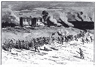
The first day of the Battle of Gettysburg during the American Civil War took place on July 1, 1863, and began as an engagement between isolated units of the Army of Northern Virginia under Confederate General Robert E. Lee and the Army of the Potomac under Union Maj. Gen. George G. Meade. It soon escalated into a major battle which culminated in the outnumbered and defeated Union forces retreating to the high ground south of Gettysburg, Pennsylvania.

On the third day of the Battle of Gettysburg during the disastrous infantry assault nicknamed Pickett's Charge, there were two cavalry battles: one approximately three miles (5 km) to the east, in the area known today as East Cavalry Field, the other southwest of the [Big] Round Top mountain.
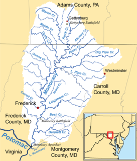
Marsh Creek is a 26.6-mile-long (42.8 km) tributary of the Monocacy River in south-central Pennsylvania and north-central Maryland in the United States.
Rock Creek is an 18.9-mile-long (30.4 km) tributary of the Monocacy River in south-central Pennsylvania and serves as the border between Cumberland and Mount Joy townships. Rock Creek was used by the Underground Railroad and flows near several Gettysburg Battlefield sites, including Culp's Hill, the Benner Hill artillery location, and Barlow Knoll.
Orland Smith was a railroad executive and a brigade commander in the Union Army during the American Civil War. In 1864, he led a spirited bayonet charge during the Battle of Wauhatchie that took a significant Confederate position on a hill that now bears his name.

The 75th Ohio Infantry Regiment, sometimes 75th Ohio Volunteer Infantry was an infantry regiment from southwestern Ohio in the Union Army during the American Civil War. It served in the Eastern Theater, most notably in the battles of Chancellorsville and Gettysburg and then in the siege operations against Charleston, South Carolina.
Pennsylvania Route 134 (PA 134), also called Taneytown Road, is a north–south, two-lane state highway in Adams County, Pennsylvania. It runs from the Maryland border at the Mason–Dixon line in Mount Joy Township north to U.S. Route 15 Business in Gettysburg. PA 134 runs through farmland between the Maryland border and an interchange with the US 15 freeway. North of here, the route passes through Round Top and serves Gettysburg National Military Park before reaching its northern terminus. Taneytown Road was created in 1800 to connect Gettysburg with Taneytown, Maryland. The road was used during the 1863 Battle of Gettysburg for the procession to the cemetery consecration at which the Gettysburg Address was delivered. PA 134 was designated to its current alignment in 1928, with the section north of Round Top paved. The southern portion of the route was paved in the 1930s.

Leopold von Gilsa was a career soldier who served as an officer in the armies of Prussia and later the United States. He is best known for his role in the misfortunes of the XI Corps in the Army of the Potomac during the American Civil War, particularly at the battles of Chancellorsville and Gettysburg, where many of his men were unjustly accused of cowardice.

Harney is an unincorporated community in Carroll County, Maryland, United States. Harney is also the home of the 'World's Best Carnival'.

The North Carolina Monument is a North Carolina memorial of the American Civil War commemorating the 32 Carolina regiments in action at the Battle of Gettysburg. The monument is a public artwork by American sculptor Gutzon Borglum located on Seminary Ridge, West Confederate Avenue, in the Gettysburg National Military Park.

Barlow, Pennsylvania is a populated place between the Gettysburg Battlefield and the Mason–Dixon line at the intersection of Rock Creek and Pennsylvania Route 134. North of the creek on the road summit is the principal facility of the rural community: the 1939 community hall at the Barlow Volunteer Fire Company fire station. The hall is a Cumberland Township polling place and was used by Mamie & Dwight D. Eisenhower after purchasing their nearby farm. Horner's Mill was the site of an 1861 Union Civil War encampment, and the covered bridge was used by the II Corps and General George G. Meade en route to the 1863 Battle of Gettysburg.
Winebrenner Run is a Pennsylvania stream in Gettysburg, Pennsylvania, flowing eastward to Rock Creek originally from a Gettys-Black Divide triple point near Zeigler's Grove. The Confederate military line along the stream was the starting point for the battle of East Cemetery Hill on the Battle of Gettysburg, Second Day, and most of the upstream portion of the run was engineered c. 1961 into underground drainage to open flow at the school complex near the Culp Farm at East Confederate Avenue.
White Run is a Pennsylvania stream which flows along the Gettysburg National Military Park and is an eponym of the Rock Creek-White Run hospital complex for field hospitals of the Battle of Gettysburg. The run's mouth is at Rock Creek near the Trostle Farm along the Sachs Road, site of a hospital east of Round Top, Pennsylvania.
References
- ↑ Harry Wilcox Pfanz (1 July 2001). Gettysburg--the first day. Univ of North Carolina Press. pp. 217, 238, 254. ISBN 978-0-8078-2624-9 . Retrieved 19 January 2012.
- ↑ Andrew B. Suhrer (2008). The Flying Dutchmen. Author House. p. 174. ISBN 978-1-4343-8630-4 . Retrieved 19 January 2012.
- ↑ Janet Hewett (1995). Supplement to the Official Records of the Union and Confederate Armies: Reports (v. 1-12, serial 1-12). Broadfoot Publishing. p. 95. ISBN 978-1-56837-275-4 . Retrieved 19 January 2012.
- ↑ Charles Teague (2001). "Barlow's Knoll Revisited". Military History Online . Retrieved 22 January 2012.
Blocher's Knoll had a distinct disadvantage. Though the swollen Rock Creek itself was a barrier of sorts, the trees along that stream as well as Blocher's Run would give cover to advancing soldiers. Barlow sought to balance that by sending four companies of the 17th Connecticut across the bridge to the Josiah Benner homestead on the far side of Rock Creek. They were there as skirmishers to blunt the advance of Gordon's troops and alert their comrades.
| | This Adams County, Pennsylvania state location article is a stub. You can help Wikipedia by expanding it. |