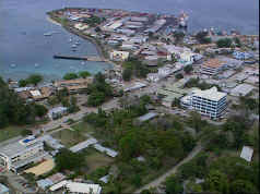
Bloody Ridge settlement | |
---|---|
Suburb | |
Coordinates: 9°26′S159°57′E / 9.433°S 159.950°E | |
Country | |
Province | Honiara Town |
Island | Guadalcanal |
Elevation | 29 m (95 ft) |
Time zone | UTC+11 (UTC) |
Bloody Ridge is a suburb of Honiara, Solomon Islands and the location of a World War II battle. [1]
Honiara is the capital city of Solomon Islands, situated on the northwestern coast of Guadalcanal. As of 2017, it had a population of 84,520 people. The city is served by Honiara International Airport and the seaport of Point Cruz, and lies along the Kukum Highway.
Solomon Islands is a sovereign state consisting of six major islands and over 900 smaller islands in Oceania lying to the east of Papua New Guinea and northwest of Vanuatu and covering a land area of 28,400 square kilometres (11,000 sq mi). The country's capital, Honiara, is located on the island of Guadalcanal. The country takes its name from the Solomon Islands archipelago, which is a collection of Melanesian islands that also includes the North Solomon Islands, but excludes outlying islands, such as Rennell and Bellona, and the Santa Cruz Islands.
World War II, also known as the Second World War, was a global war that lasted from 1939 to 1945. The vast majority of the world's countries—including all the great powers—eventually formed two opposing military alliances: the Allies and the Axis. A state of total war emerged, directly involving more than 100 million people from more than 30 countries. The major participants threw their entire economic, industrial, and scientific capabilities behind the war effort, blurring the distinction between civilian and military resources. World War II was the deadliest conflict in human history, marked by 70 to 85 million fatalities, most of whom were civilians in the Soviet Union and China. It included massacres, the genocide of the Holocaust, strategic bombing, premeditated death from starvation and disease, and the only use of nuclear weapons in war.
Chinatown is a suburb of Honiara, Solomon Islands located South East of the main center. It contains the 56-room Honiara Hotel.
Burns Creek is a suburb of Honiara, Solomon Islands located to the East of the main center, South of Lungga Point and West of Henderson.
Vura is a suburb in Honiara, Solomon Islands located East of the main center.
Honiara Golf Course is an actual golf course in the Auki suburb of Honiara, Solomon Islands.
Mbokona is a suburb of Honiara, Solomon Islands and is located South of the main center.
Tuvaruhu is a suburb of Honiara, Solomon Islands, south of Point Cruz.
East Kola'a Ridge is a suburb of Honiara, Solomon Islands and is located east of Chinatown.
Ferakusia is a suburb of Honiara, Solomon Islands and is located South of Chinatown.
Bahai Centre is a suburb of Honiara, Solomon Islands and is located West of Kukum.
Kola'ale is a suburb of Honiara, Solomon Islands and is located South of Kukum.
Gilbert Camp is a suburb of Honiara, Solomon Islands and is located South of Kukum.
Panatina is a suburb of Honiara, Solomon Islands and is located West of the main center.
Naha is a suburb of Honiara, Solomon Islands and is located South of Kukum.
Ranadi is a suburb of Honiara, Solomon Islands and is located West of Panatina.
Panatina Creek is a suburb of Honiara, Solomon Islands and is located South of Ranadi.
Lungga is a suburb of Honiara, Solomon Islands and is located east of the main center on Lungga Point.
Betikama is a suburb of Honiara, Solomon Islands and is located South of Lungga Point.
Lungga Plantation is a suburb of Honiara, Solomon Islands and is located East of Lungga Point.
NZ Camp is a suburb of Honiara, Solomon Islands and is located South-East of Honiara International Airport.
Henderson Central is a suburb of Honiara, Solomon Islands and is located near the Honiara International Airport.
Coordinates: 8°46′S160°42′E / 8.767°S 160.700°E
A geographic coordinate system is a coordinate system that enables every location on Earth to be specified by a set of numbers, letters or symbols. The coordinates are often chosen such that one of the numbers represents a vertical position and two or three of the numbers represent a horizontal position; alternatively, a geographic position may be expressed in a combined three-dimensional Cartesian vector. A common choice of coordinates is latitude, longitude and elevation. To specify a location on a plane requires a map projection.
This Solomon Islands location article is a stub. You can help Wikipedia by expanding it. |