Related Research Articles

South Africa occupies the southern tip of Africa, its coastline stretching more than 2,850 kilometres from the desert border with Namibia on the Atlantic (western) coast southwards around the tip of Africa and then northeast to the border with Mozambique on the Indian (eastern) coast. The low-lying coastal zone is narrow for much of that distance, soon giving way to a mountainous escarpment that separates the coast from the high inland plateau. In some places, notably the province of KwaZulu-Natal in the east, a greater distance separates the coast from the escarpment. Although much of the country is classified as semi-arid, it has considerable variation in climate as well as topography. The total land area is 1,220,813 km2 (471,359 sq mi). It has the 23rd largest Exclusive Economic Zone of 1,535,538 km2 (592,875 sq mi).

KwaZulu-Natal is a province of South Africa that was created in 1994 when the government merged the Zulu bantustan of KwaZulu and Natal Province.

The Drakensberg is the eastern portion of the Great Escarpment, which encloses the central Southern African plateau. The Great Escarpment reaches its greatest elevation – 2,000 to 3,482 metres within the border region of South Africa and Lesotho.

Isandlwana is an isolated hill in the KwaZulu-Natal province of South Africa. It is located 169 kilometres (105 mi) north by northwest of Durban. The name is said to mean abomasum, the second stomach of the cow, because it reminded the Zulus of its shape.

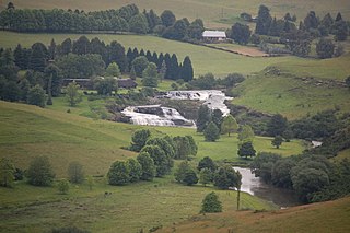
The Tugela River is the largest river in KwaZulu-Natal Province, South Africa. With a total length of 560 km (350 mi), and a drop of 1 370 metres in the lower 480 km, it is one of the most important rivers of the country.
Mont-aux-Sources is a mountain in Southern Africa, forming one of the highest portions of the Drakensberg Range. It is mostly within Lesotho, with parts in the KwaZulu-Natal and Free State provinces of South Africa.

The Umfolozi River is a river in KwaZulu-Natal, a province of South Africa. It is formed by the confluence of the Black and White Umfolozi Rivers near the southeastern boundary of the Hluhluwe-Umfolozi Game Reserve. The isiZulu name imFolozi is generally considered to describe the zigzag course followed by both tributaries, though other explanations have been given.

The Great Escarpment is a major topographical feature in Africa that consists of steep slopes from the high central Southern African plateau downward in the direction of the oceans that surround southern Africa on three sides. While it lies predominantly within the borders of South Africa, in the east the escarpment extends northward to form the border between Mozambique and Zimbabwe, continuing on beyond the Zambezi river valley to form the Muchinga Escarpment in eastern Zambia. In the west, it extends northward into Namibia and Angola. It is the combination of this escarpment and the aridity of Southern Africa that leads to the lack of navigable rivers in South Africa.

Blood/Ncome River is situated between Nquthu and Vryheid in KwaZulu-Natal, South Africa. This river has its sources in the hills south-east of Utrecht; leaving the highlands it is joined by two important tributaries that originate in the Schurveberg, after which it flows meandering through a sandy plain. The Blood River is a tributary of the Buffalo River, which is a tributary of the Thukela River which it joins from the north-east.
The Mooi River is a river in KwaZulu-Natal Province, South Africa. It rises in the Mkomazi Nature Reserve in the Drakensberg Mountains, and empties into the Tugela River near Muden. The town of Mooi River lies on the river.

The Zulu Kingdom, sometimes referred to as the Zulu Empire or the Kingdom of Zululand, was a monarchy in Southern Africa. During the 1810s, Shaka established a standing army that consolidated rival clans and built a large following which ruled a wide expanse of Southern Africa that extended along the coast of the Indian Ocean from the Tugela River in the south to the Pongola River in the north.
The Diocese of Zululand is a diocese of the Anglican Church of Southern Africa which covers the part of the South African province of KwaZulu-Natal that lies to the northeast of the Buffalo and Tugela Rivers. It is divided in ten archdeaconries.

The Bushman's River is an east to north-easterly flowing tributary of the Tugela River, in the KwaZulu-Natal province of South Africa. It rises in the Drakensberg Mountain range, with its upper catchment in the Giant's Castle Game Reserve, north of the Giant's Castle promontory. It feeds the Wagendrift Dam and then flows past the town of Estcourt to join the Tugela River near the town of Weenen.

Msinga Municipality is a local municipality within the Umzinyathi District Municipality, in the KwaZulu-Natal province of South Africa. Msinga is an isiZulu word meaning "a current in the sea where air movement causes ripples on top of the water surface and ends up influencing the nearby climatic conditions through its breeze". The municipality is largely located in deep gorges of the Tugela and Buffalo rivers, isolated from the immediate surrounding municipal areas. The population dynamics result in a growing rural area and a declining urban area in the municipality, contrary to most other areas in the country. This can be attributed to the fact that the urban areas of municipality are very small and are unable to provide the normal range of goods and services provided in urban areas.

The Buffalo River is the largest tributary of the Tugela River in South Africa. With a total length of 426 km (265 mi), its source is in Majuba Hill, "Hill of Doves" in the Zulu language, located northeast of Volksrust, close to the Mpumalanga / KwaZulu-Natal border. It follows a southerly route into KwaZulu-Natal past Newcastle then turns southeast past Rorke's Drift, before joining the Tugela River at Ngubevu near Nkandla. During the nineteenth century it formed part of the boundary between the Colony of Natal and Zululand.
Bloukrans River may refer to any of the following rivers in South Africa:

Spion Kop is a mountain in the province of KwaZulu-Natal, South Africa. It is located near the town of Ladysmith, 27 km to the WSW and about 2.5 km to the north of the Spioenkop Dam, a reservoir for the waters of the Tugela River.

The Wilge River is a tributary of the Vaal River in central South Africa. This river is important as part of the Tugela-Vaal Water Transfer Scheme where water is transferred from the Tugela River basin to the Vaal River basin.

The Piet Retief Delegation massacre was the 1838 killing of 100 Voortrekkers by the Zulu king Dingane in what is now KwaZulu-Natal, South Africa. The Voortrekkers, led by Piet Retief, migrated into Natal in 1837 and negotiated a land treaty in February 1838 with Dingane. Upon realizing the ramifications of the imposed contract, Dingane betrayed the Voortrekkers, killing the delegation including Retief on 6 February 1838. The land treaty was later found in Retief's possession. It gave the Voortrekkers the land between the Tugela River and Port St. Johns. This event eventually led to the Battle of Blood River and the eventual defeat of Dingane.

The Klip River is a main tributary of the Tugela River in KwaZulu-Natal, South Africa. The river originates on the west side of KwaZulu-Natal, initially flows eastward and then swings southward. It flows into the Windsor Dam, and then into the larger Qedusizi Dam before flowing east again. The river passes through Ladysmith before joining the Tugela River.
References
- ↑ du Plessis, E.J. (1973). Suid-Afrikaanse berg- en riviername. Tafelberg-uitgewers, Cape Town. pp. 204–205, 281, 307. ISBN 0-624-00273-X.
28°55′34″S29°44′33″E / 28.92611°S 29.74250°E
| | This KwaZulu-Natal location article is a stub. You can help Wikipedia by expanding it. |
| | This article related to a river in South Africa is a stub. You can help Wikipedia by expanding it. |