
The James River is a river in the U.S. state of Virginia that begins in the Appalachian Mountains and flows 348 miles (560 km) to Chesapeake Bay. The river length extends to 444 miles (715 km) if one includes the Jackson River, the longer of its two source tributaries. It is the longest river in Virginia. Jamestown and Williamsburg, Virginia’s first colonial capitals, and Richmond, Virginia's current capital, lie on the James River.

The Blue Ridge Parkway is a National Parkway and All-American Road in the United States, noted for its scenic beauty. The parkway, which is America's longest linear park, runs for 469 miles (755 km) through 29 Virginia and North Carolina counties, linking Shenandoah National Park to Great Smoky Mountains National Park. It runs mostly along the spine of the Blue Ridge, a major mountain chain that is part of the Appalachian Mountains. Its southern terminus is at U.S. Route 441 (US 441) on the boundary between Great Smoky Mountains National Park and the Qualla Boundary of the Eastern Band of Cherokee Indians in North Carolina, from which it travels north to Shenandoah National Park in Virginia. The roadway continues through Shenandoah as Skyline Drive, a similar scenic road which is managed by a different National Park Service unit. Both Skyline Drive and the Virginia portion of the Blue Ridge Parkway are part of Virginia State Route 48 (SR 48), though this designation is not signed.
A National Parkway is a designation for a protected area in the United States. The designation is given to a scenic roadway and a protected corridor of surrounding parkland. National Parkways often connect cultural or historic sites. The U.S. National Park Service manages the parkways.
King's Highway 33, commonly referred to as Highway 33 or Loyalist Parkway, is a provincially maintained highway in the Canadian province of Ontario. The route begins at Highway 62 in Bloomfield and travels east to the Collins Bay Road junction at Collins Bay in the city of Kingston, a distance of 60.9 kilometres (37.8 mi). The highway continues farther east into Kingston as Bath Road, ending at the former Highway 2, now Princess Street. Highway 33 is divided into two sections by the Bay of Quinte. The Glenora Ferry service crosses between the two sections just east of Picton, transporting vehicles and pedestrians for free throughout the year.
Route 110, consisting of State Route 110 and Interstate 110 (I-110), is a state and auxiliary Interstate Highway in the Los Angeles metropolitan area of the U.S. state of California. The entire route connects San Pedro and the Port of Los Angeles with Downtown Los Angeles and Pasadena. The southern segment from San Pedro to Interstate 10 in downtown Los Angeles is signed as I-110, while the northern segment to Pasadena is signed as SR 110. The entire length of I-110, as well as SR 110 south of the Four Level Interchange with US 101, is the Harbor Freeway, and SR 110 north from US 101 to Pasadena is the historic Arroyo Seco Parkway, the first freeway in the western United States. I-110 is one of two 3-digit interstate designations to appear on opposite coasts; I-280 in California and New Jersey is the other.

A National Scenic Byway is a road recognized by the United States Department of Transportation for one or more of six "intrinsic qualities": archeological, cultural, historic, natural, recreational, and scenic. The program was established by Congress in 1991 to preserve and protect the nation's scenic but often less-traveled roads and promote tourism and economic development. The National Scenic Byways Program (NSBP) is administered by the Federal Highway Administration (FHWA).

Parkway Drive are an Australian metalcore band from Byron Bay, New South Wales, formed in 2003. As of 2018, Parkway Drive have released six studio albums, one EP, two DVDs, a split album and one book, titled Ten Years of Parkway Drive. The band's latest four albums have reached the top 10 of the Australian ARIA Charts, with Ire reaching number 1 in October 2015, and Reverence in May 2018.
The George Washington Memorial Parkway, colloquially the G.W. Parkway, is a 25-mile-long (40 km) parkway that runs along the south bank of the Potomac River from Mount Vernon, Virginia, northwest to McLean, Virginia, and is maintained by the National Park Service (NPS). It is located almost entirely within Virginia, except for a short portion of the parkway northwest of the Arlington Memorial Bridge that passes over Columbia Island within the District of Columbia.

State Route 895, also known as the Pocahontas Parkway and Pocahontas 895, is a primary state highway in the U.S. state of Virginia. It connects the junction of Interstate 95 and State Route 150 in Chesterfield County with Interstate 295 near Richmond International Airport in Henrico County, forming part of a southeastern bypass of Richmond. Due to a quirk in the evolution of the road, the long-planned designation of Interstate 895 could not be used.

King's Highway 26, commonly referred to as Highway 26, is a provincially maintained highway in the Canadian province of Ontario, connecting the cities of Barrie and Owen Sound. Between these two cities, the highway serves the southern shoreline of Georgian Bay, passing through Stayner, Collingwood and Meaford and by the Blue Mountain Resort. In addition, the highway serves as the main route to Wasaga Beach, a popular recreational destination during the summer months.

State Route 515 (SR 515) is a 76.2-mile-long (122.6 km) four-lane C-shaped state highway in the northern part of the U.S. state of Georgia. It begins just west of Nelson. It curves to the northeast to Lake Chatuge, where it heads north to the North Carolina state line. The highway was built to give motorists in the north Georgia mountains better access to Atlanta and its outlying suburbs, as opposed to the old SR 5 and U.S. Route 76 (US 76) highways, which this project replaced.
The Martha Layne Collins Blue Grass Parkway is a controlled-access highway running from Elizabethtown, Kentucky to Woodford County, Kentucky, for a length of 71.134 miles (114.479 km). It intersects with Interstate 65 at its western terminus, and U.S. Route 60 at its eastern terminus. It is one of seven highways that are part of the Kentucky parkway system. The road is designated unsigned Kentucky Route 9002. It is constructed similar to the Interstate Highway system, though sections do not measure up to current Interstate standards.

U.S. Route 66 is a part of a former United States Numbered Highway in the state of California that ran from the west in Santa Monica on the Pacific Ocean through Los Angeles and San Bernardino to Needles at the Arizona state line. It was truncated during the 1964 renumbering and its signage removed in 1974. The highway is now mostly replaced with several streets in Los Angeles, State Route 2 (SR 2), SR 110, SR 66, San Bernardino County Route 66 (CR 66), Interstate 15 (I-15), and I-40.
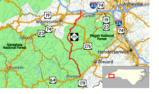
North Carolina Highway 215 (NC 215) is a highway in western North Carolina that runs from the town of Rosman in Transylvania County to Canton at Interstate 40 and U.S. Route 74 (US 74). The portion from Canton to Rosman is a part of the US Forest Service's Forest Heritage Scenic Byway. It travels high into the mountains along a scenic stretch of the upper West Fork of the Pigeon River, and intersects the Blue Ridge Parkway at Beech Gap at an elevation of approximately 5,300 feet (1,600 m).
Road to nowhere may refer to:

A scenic route, tourist road, tourist route, tourist drive, holiday route, theme route, or scenic byway is a specially designated road or waterway that travels through an area of natural or cultural beauty. The designation is usually determined by a governmental body, such as a Department of Transportation or a Ministry of Transport.

In the U.S. state of North Carolina U.S. Route 221 (US 221) is a north–south highway that travels through Western North Carolina. From Chesnee, South Carolina to Independence, Virginia, it connects the cities of Rutherfordton, Marion, Boone and Jefferson between the two out-of-state destinations. Its most memorable section, known as the Little Parkway Scenic Byway between Linville and Blowing Rock, offers area visitors a curvier alternative to the Blue Ridge Parkway and access to Grandfather Mountain.