
Northampton County is a county in the Commonwealth of Pennsylvania, United States. As of the 2020 census, the population was 312,951. Its county seat is Easton. The county was formed in 1752 from parts of Bucks County. Its namesake was the county of Northamptonshire in England, and the county seat of Easton was named for Easton Neston, a country house in Northamptonshire.

Bangor, or West Bangor, to differentiate it from its immediate neighbor East Bangor, is a borough located in Northampton County, Pennsylvania, United States. It is located 32 miles (51 km) north of Allentown. It had a population of 5,187 as of the 2020 census.
Pen Argyl is a borough in Northampton County, Pennsylvania. The borough's population was 3,510 as of the 2020 census.

Plainfield Township is a township in Northampton County, Pennsylvania, United States. The population of Plainfield Township was 6,138 at the 2010 census. The township is part of the Lehigh Valley metropolitan area, which had a population of 861,899 and was the 68th-most populous metropolitan area in the U.S. as of the 2020 census.

The Lehigh Valley is a geographic and metropolitan region formed by the Lehigh River in Lehigh and Northampton counties in eastern Pennsylvania. It is a component valley of the Great Appalachian Valley bounded to its north by Blue Mountain, to its south by South Mountain, to its west by Lebanon Valley, and to its east by the Delaware River and Warren County, New Jersey. The Lehigh Valley is about 40 miles (64 km) long and 20 miles (32 km) wide. The Lehigh Valley's largest city is Allentown, the third-largest city in Pennsylvania and the county seat of Lehigh County, with a population of 125,845 residents as of the 2020 census.

Martins Creek is a 10.4-mile-long (16.7 km) tributary of the Delaware River in eastern Pennsylvania in the United States. In all, the main creek and its two branches drain an area of 46.7 square miles. Martins Creek joins the Delaware just south of the town of Martins Creek.
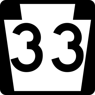
Pennsylvania Route 33 is a 27.7-mile-long (44.6 km) freeway in eastern Pennsylvania. The highway runs from its interchange with Interstate 78 (I-78) south of Easton in the Lehigh Valley to I-80 and PA 611 west of Stroudsburg.
Nazareth High School is a public high school located in Nazareth, Pennsylvania in the Lehigh Valley region of eastern Pennsylvania. It is the only high school in the Nazareth Area School District and serves grades 9 through 12. Its mascot is the Blue Eagle and school colors are blue and white.
Pen Argyl Area High School is a four-year public high school located in Pen Argyl, Pennsylvania in the Lehigh Valley region of eastern Pennsylvania. It is the only high school in the Pen Argyl Area School District. As of the 2021–22 school year, the school had an enrollment of 502 students, according to National Center for Education Statistics data.
Pennsylvania State Senate District 18 includes parts of Lehigh and Northampton counties in the Lehigh Valley region of eastern Pennsylvania. It is currently represented by Democrat Lisa Boscola.

The Colonial League is an athletic conference consisting of 14 high schools mostly from the Lehigh Valley portion of eastern Pennsylvania. It is part of District XI of the Pennsylvania Interscholastic Athletic Association. The Colonial League is designed for mid and small-size schools in the Lehigh Valley. The largest 18 schools in the Lehigh Valley and Pocono region compete in the Eastern Pennsylvania Conference, one of the premiere athletic divisions in the nation.
District 11 of the Pennsylvania Interscholastic Athletic Association (PIAA) is an interscholastic athletic association in eastern Pennsylvania.

Ackermanville is a census-designated place located on PA Route 191 in Washington Township, Northampton County, Pennsylvania, United States. As of the 2022 American Community Survey, the village's population was 280. Ackermanville is part of the Lehigh Valley metropolitan area, which had a population of 861,899 and was the 68th-most populous metropolitan area in the U.S. as of the 2020 census. It was named for the Ackerman family.
Marcia M. Hahn is a politician from the U.S. state of Pennsylvania. A member of the Republican Party, she represented the 138th district in the Pennsylvania House of Representatives from 2010 to 2020.
The Blue Mountain League was a minor league baseball league that played in the 1907 season. The four–team Independentlevel Blue Mountain League consisted of franchises based exclusively in Pennsylvania. The Blue Mountain League permanently folded following one season of play.
The Pen Argyl team was a minor league baseball team based in Pen Argyl, Pennsylvania in 1907. Pen Argyl played as members of the Independent level Blue Mountain League. The 1907 team was without a known moniker and was the only minor league team known to be hosted in Pen Argyl.
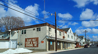
The Slate Belt is a geographic region in Northampton County, Pennsylvania that is typically described as including Bangor, Wind Gap, Pen Argyl, and Portland. The region is named for the historical prevalence of slate quarrying in the area.

Memorial Library of Nazareth & Vicinity, also known as the Nazareth Memorial Library, is a public library located in Nazareth, Pennsylvania. It serves the borough of Nazareth and the townships of Bushkill, Upper Nazareth, and Lower Nazareth.
Northampton Area Public Library is a library located in Northampton, Pennsylvania. It serves the residents of the Northampton Area School District. The library was established in 1965.
Mary Meuser Memorial Library is a public library located in Wilson, Pennsylvania. It serves the residents of Wilson Area School District. The library has approximately 50,000 items.
