Related Research Articles

Kendall County is a county located on the Edwards Plateau in the U.S. state of Texas. In 2020 census, its population was 44,279. Its county seat is Boerne. The county is named for George Wilkins Kendall, a journalist and Mexican–American War correspondent.

Guadalupe County is a county located in the U.S. state of Texas. As of the 2020 census, its population was 172,706. The county seat is Seguin. The county was founded in 1846 and is named after the Guadalupe River.

Culberson County is a county located in the U.S. state of Texas. As of the 2020 census, its population was 2,188. The county seat is Van Horn. Culberson County was founded in 1911 and organized the next year. It is named for David B. Culberson, a Confederate soldier and U.S. representative.

Comal County is a county located on the Edwards Plateau in the U.S. state of Texas. As of the 2020 census, its population was 161,501. Comal County is known for its rich German-Texan and European history. Its county seat is New Braunfels.
The United Services Automobile Association (USAA) is an American financial services company providing insurance and banking products exclusively to members of the military, veterans and their families. It was founded in 1922 in San Antonio, Texas, by a group of 25 U.S. Army officers as a mechanism for mutual self-insurance, when they were unable to secure auto insurance because of the perception that they, as military officers, were a high-risk group.

The University of Texas at San Antonio (UTSA) is a public research university in San Antonio, Texas. Established in 1969, UTSA is the largest university in San Antonio and the eighth-largest by enrollment in the state of Texas enrolling over 34,000 students across its five campuses spanning more than 758 acres. It is classified among "R1: Doctoral Universities – Very High Research Activity". The UTSA Institute for Economic Development generates $2.6 billion in direct economic impact.

South Texas is a geographic and cultural region of the U.S. state of Texas that lies roughly south of—and includes—San Antonio. The southern and western boundary is the Rio Grande, and to the east it is the Gulf of Mexico. The population of this region is about 4.96 million according to the 2017 census estimates. The southern portion of this region is often referred to as the Rio Grande Valley. The eastern portion along the Gulf of Mexico is also referred to as the Coastal Bend.
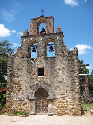
Mission San Francisco de la Espada is a Roman Rite Catholic mission established in 1690 by Spain and relocated in 1731 to present-day San Antonio, Texas, in what was then known as northern New Spain. The mission was built in order to convert local Native Americans to Christianity and solidify Spanish territorial claims in the New World against encroachment from France. Today, the structure is one of four missions that comprise San Antonio Missions National Historical Park.
The Texas Blackland Prairies are a temperate grassland ecoregion located in Texas that runs roughly 300 miles (480 km) from the Red River in North Texas to San Antonio in the south. The prairie was named after its rich, dark soil. Less than 1% of the original Blackland prairie vegetation remains, scattered across Texas in parcels.

Central Catholic High School is a Catholic, all-male, non-boarding college preparatory school located in the River North District of Downtown San Antonio, Texas, USA, in the Roman Catholic Archdiocese of San Antonio.

Our Lady of the Lake University (OLLU), known locally as the Lake, is a private Catholic university in San Antonio, Texas. It was founded in 1895 by the Sisters of Divine Providence, a religious institute originating in Lorraine, France, during the 18th century. The Texas chapter of the institute still sponsors the university. Our Lady of the Lake University was the first San Antonio institution of higher education to receive regional accreditation and its Worden School of Social Service is the oldest Social Work school in Texas.

Choke Canyon Reservoir is a reservoir in South Texas, United States. The lake and the dam that creates it are owned by the United States Bureau of Reclamation and managed by the City of Corpus Christi.

The geography of Texas is diverse and large. Occupying about 7% of the total water and land area of the U.S., it is the second largest state after Alaska, and is the southernmost part of the Great Plains, which end in the south against the folded Sierra Madre Oriental of Mexico. Texas is in the South Central United States of America, and is considered to form part of the U.S. South and also part of the U.S. Southwest.

Green Lake is a natural tidal lake in Calhoun County, Texas, on the Guadalupe River flood basin. Known for its greenish waters, from which its name derives, the lake is located 12 miles (19 km) west of Port Lavaca and 22 miles (35 km) south of Victoria on the Gulf Coastal Plain. Despite being less than 3 miles (4.8 km) from the coast of San Antonio Bay, its waters are fresh. It is the largest natural freshwater lake entirely in Texas, covering an area of approximately 10,000 acres (40 km2).

Wilford Hall Ambulatory Surgical Center (WHASC), formerly known as Wilford Hall Medical Center, is a U.S. Air Force medical treatment facility located on the grounds of San Antonio's Lackland Air Force Base. Operated by the 59th Medical Wing, Wilford Hall is the Defense Department's largest outpatient ambulatory surgical center, providing the full spectrum of primary care, specialty care, and outpatient surgery. The medical facility is named after former Air Force physician, Maj. Gen. Wilford F. Hall, a visionary pioneer whose contributions were instrumental in the development of aeromedical evacuation.

Oblate School of Theology is a Catholic graduate school for theological studies and spirituality in San Antonio, Texas. It was founded in 1903 by the Missionary Oblates of Mary Immaculate. Louis Studer, OMI, has served as its president since July 2024.
Thomas Jefferson High School is a public high school in San Antonio, Texas, United States, and is one of ten high schools in the San Antonio Independent School District. Completed in 1932 at a cost of $1,250,000, it was the third high school built in the city. For the 2021-2022 school year, the school was given a "B" by the Texas Education Agency.
The Blue Wing Solar Project is a 16.6 MWp (14.4 MWAC) solar photovoltaic (PV) power plant in San Antonio, Texas. It was one of the largest PV facilities in Texas when it came online in late 2010 and is owned by a Duke Energy Subsidiary.

George Washington Brackenridge was a philanthropist and the longest-serving Regent for the University of Texas. His donations of time, land holdings and wealth expanded the university and provided educational opportunities for women and other minorities. He was an advocate of women's suffrage and women's educational opportunities. He was also a business man who made his initial wealth as a profiteer during the Civil War. Brackenridge organized two banking institutions in San Antonio and served as their president. He was president of the San Antonio Water Works Company. Alamo Heights in Bexar County was once his residence and was named by him. His mansion Fernridge is now part of University of the Incarnate Word campus. Brackenridge Park, San Antonio Japanese Tea Garden and Mahncke Park in San Antonio were made possible through his donations of land holdings.

The U.S. state of Texas has a series of estuaries along its coast on the Gulf of Mexico, most of them bounded by the Texas barrier islands. Estuaries are coastal bodies of water in which freshwater from rivers mixes with saltwater from the sea. Twenty-one drainage basins terminate along the Texas coastline, forming a chain of seven major and five minor estuaries: listed from southwest to northeast, these are the Rio Grande Estuary, Laguna Madre, the Nueces Estuary, the Mission–Aransas Estuary, the Guadalupe Estuary, the Colorado–Lavaca Estuary, East Matagorda Bay, the San Bernard River and Cedar Lakes Estuary, the Brazos River Estuary, Christmas Bay, the Trinity–San Jacinto Estuary, and the Sabine–Neches Estuary. Each estuary is named for its one or two chief contributing rivers, excepting Laguna Madre, East Matagorda Bay, and Christmas Bay, which have no major river sources. The estuaries are also sometimes referred to by the names of their respective primary or central water bodies, though each also includes smaller secondary bays, inlets, or other marginal water bodies.
References
- ↑ U.S. Geological Survey Geographic Names Information System: Lake Waxahachie
- 1 2 3 Association, Texas State Historical. "Blue Wing Lake". Texas State Historical Association. Retrieved 2024-07-30.
- 1 2 "Blue Wing Lake, Texas | Lake, Fishing & Travel Info". Lake-Link. Retrieved 2024-07-30.
- ↑ "Blue Wing Lake, Bexar County, Texas". digital.utsa.edu. Retrieved 2024-07-30.
 | This article about a location in Bexar County, Texas is a stub. You can help Wikipedia by expanding it. |
| | This article related to a lake in the United States is a stub. You can help Wikipedia by expanding it. |