Ouazzane is a town in northern Morocco, with a population of 59,606 recorded in the 2014 Moroccan census.

Martil is a Town northeast of the city of Tetouan. Province du Tanger-Tetouan-Al Hoceima Morocco in the Mediterranean Sea.
Fnideq is a town in northern Morocco, on the Mediterranean coast of M'diq-Fnideq Prefecture, situated 31 kilometres north of the city of Tétouan. The town is also known under the Spanish name Castillejos. It is located near the Spanish exclave of Ceuta.

Sidi Slimane is a small city in the northwestern centre of Morocco in the Rabat-Salé-Kénitra economic region. It is the administrative headquarters for Sidi Slimane Province and is located between the major cities of Kenitra and Meknes.

Figuig is a province in the Oriental Region of Morocco. Its capital is Bouarfa. It recorded a population of 138,325 in the 2014 Moroccan census, up from 129,430 in 2004.
Fdalate is a town and rural commune in Benslimane Province, Casablanca-Settat, Morocco. According to the 2004 census it has a population of 9,796.
El Gara is a town in Berrechid Province, Casablanca-Settat, Morocco. According to the 2014 Moroccan census it recorded a population of 20,855, up from 18,070 in the 2004 census.
Oulad Abbou is a town in Berrechid Province, Casablanca-Settat, Morocco. According to the 2014 Moroccan census it recorded a population of 11,299, up from 10,748 in the 2004 census.
Youssoufia is the capital of Youssoufia Province in Marrakesh-Safi, Morocco. In the 2014 Moroccan census it recorded a population of 67,628, up from 64,518 ten years ago.
Bni Tadjite is a rural commune and town in Figuig Province, Oriental, Morocco. According to the 2004 census the town had a population of 8,029.
Bouanane is a town and rural commune in Figuig Province, Oriental, Morocco. According to the 2004 census the town had a population of 3,254.
Talsint is a town and rural commune in Figuig Province, Oriental, Morocco. According to the 2004 census it had a population of 7,098.

Beni Ensar or Aït Nsar is a town in Nador Province, Oriental, Morocco, located 12 km north of the city of Nador. It is bordered on the north by the Spanish-controlled city of Melilla. According to the 2014 census Beni Ensar has a population of 56,582, and its area is 20 hectares (0.2 km²).

Bouarfa, is a city in Oriental Region in northeastern Morocco and the capital of Figuig Province. According to the 2004 census it had a population of 24,527. The city is a cultural hub for the Beni Guil, a nomadic Arab tribe.
Tabant is a small town and rural commune in Azilal Province, Béni Mellal-Khénifra, Morocco. At the time of the 2014 census, the commune had a total population of 14,963 people living in 2194 households.
Assebbab is a commune in Guercif Province of the Oriental administrative region of Morocco. At the time of the 2004 census, the commune had a total population of 6721 people living in 948 households. The 2014 census recorded a population of 7069 living in 1083 households.

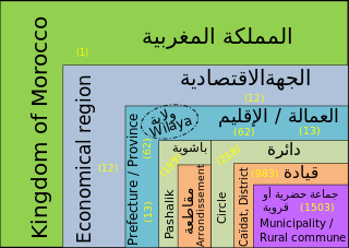
Oujda-Angad Prefecture is an urban prefecture located within the Oriental Region, and in the northeastern Rif area, of northeast Morocco.
Moulay Yacoub is a spa town and municipality located 21 km northwest of Fez, Morocco. It is the capital of Moulay Yacoub Province and reported a population of 4612 in the 2014 Moroccan census. The baths use water pumped from 1500 m below ground and reach a temperature of 54 °C.