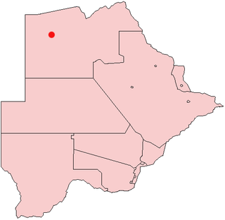
The North-West District or Ngamiland is one of the first-level administrative subdivisions of Botswana. For census and administrative purposes Ngamiland is subdivided into Ngamiland East, Ngamiland West and Ngamiland Delta (Okavango). It is governed by a District Commissioner, appointed by the national government, and the elected North-West District Council. The administrative centre is Maun.

Gumare or Gomare is a rural village located in the North-West District of Botswana, near the Okavango Delta. The population of Gumare was 6,067 in 2001 census, but had risen to 8,532 iby the 2011 census.
Nokaneng is a village in North-West District, Botswana. It is located close to the Okavango Delta, and is served by Nokaneng Airport. The population of Nokaneng was 1,590 in 2001 census.
Seronga is a village in North-West District, Botswana. It is located close to beginning of the Okavango Delta, and has a local airstrip. The population of Seronga was 1,641 in 2001 census. In 2011 population census, the village had a population of 3716 making it the fourth largest village in Ngamiland West. Seronga village has two government schools namely; Seronga Primary School and Ngambao Junior Secondary School. In addition, Seronga village has other government facilities namely Seronga Sub-Land Board, Seronga Police Station, Seronga Airfield, National Parks and Wildlife Office, Tribal Administration office headed by Senior Chief Representative, 24 hour Clinic with a Doctor.
Semboyo is a village in North-West District of Botswana. It is located in the southern part of the district, close to the Okavango Delta and Lake Ngami, and has a primary school. The population was 246 in 2001 census.
Sehithwa is a village in North-West District of Botswana. It is located in the southern part of the district, close to Lake Ngami. The population was 1,478 in 2001 census.
Tsao or Tsau is a village in North-West District of Botswana. It is located close to the Okavango Delta and Lake Ngami. The population was 1,290 in 2001 census.
Tsootsha, also known as Kalkfontein, is a village in Ghanzi District of Botswana. It is located close to the border with Namibia. The population was 1,397 in 2001 census.
Makunda is a village in Ghanzi District of Botswana. It is located close to the Namibian border. The population was 331 in 2001 census.
Kule is a village in Ghanzi District of Botswana. It is located close to the border with Namibia and has a primary school, clinic, customary court, social and development offices, animal health and production and police offices. The population was 741 in 2001 census.
New Xanagas is a village in Ghanzi District of Botswana. It is located western part of the district. New Xanagas has a primary school and the population was 540 in 2001 census.
Nata is a village in the Central District of Botswana. Located in the north of the district, the village is served by Nata Airport. The population was 6,802 at the 2011 census. The village of Nata lies along the Nata River, which carries its rainy season flow to the Makgadikgadi Pans, a seasonal hypersaline lake.The village has 6 wards named Sekao, Maaloso, Kachikao, Manakanagore, Makwenaejang and Basimane.
Lerala is a village in Central District of Botswana. The village is located at the south-eastern end of the Tswapong Hills, 30 km (19 mi) from the Limpopo River and the border with South Africa and approximately 90 km (56 mi) east of Palapye. The population of Lerala was 6,871 in the 2011 census, which was a 20.5% increase from the 2001 population.
Oodi or Odi is a village in Kgatleng District of Botswana. It is located 20 km north-east of Gaborone. The population was 5,687 in 2011 census.
Bokaa is a village in Kgatleng District of Botswana. The village is located around 20 km south-west of Mochudi and the population was 5,765 in 2011 census. The village is just north of the Bokaa Dam.
Boatlaname is a village in Kweneng District of Botswana. The population of Boatlaname was 770 in 2001 census.
Kopong is a small village in Kweneng District of Botswana. It is located around 25 km north of Gaborone, the capital of Botswana. The population was 5,571 in 2001 census and 9,520 at the 2011 census, making it the sixth largest settlement in Kweneng. It is now becoming a suburb of Gaborone agglomeration home to 421,907 inhabitants at the 2011 census.

Chobe District is an administrative district in the northern part of Botswana, with the headquarters in Kasane. In 2001 it was merged with Ngamiland, and until 2006 it shared with Ngamiland the North-West District Council as local government. Chobe National Park is in the Chobe District. As of 2011, the total population of the district was 23,347 compared to 18,258 in 2001. The growth rate of population during the decade was 2.49. The total number of workers constituted 12,059 with 6,113 males and 5,947 females, with majority of them working in public administration.
Etsha 6 is a village in Ngamiland West sub-district of North-West District, Botswana. The population was 5,613 in the 2001 census.
Etsha is an area of villages in the Ngamiland West sub-district of Botswana. Refugees from the 1969 war in Angola were resettled in the area and formed 13 villages numbered Etsha 1 to Etsha 13. A resettlement study was published about it in the 1970s. A study of basketmakers in Etsha was published in 1984. The development of commercial craft industries have been targeted in the community, including palm-frond weaving.


