A boggart is a creature in English folklore, either a household spirit or a malevolent genius loci inhabiting fields, marshes, or other topographical features. Other names of this group include bug, bugbear, bogey, bogun, bogeyman, bogle, etc., presumably all derived from Old English pūcel, and related to the Irish púca and the pwca or bwga of Welsh mythology.

The A58 is a major road in Northern England running between Prescot, Merseyside and Wetherby, West Yorkshire.

Blackley and Broughton is a constituency represented in the House of Commons of the UK Parliament by Graham Stringer. He was first elected in 1997 for the former Manchester Blackley and prior to this was Leader of Manchester City Council. The constituency covers north Manchester and east Salford.
Volodarka is an urban-type settlement located on the Ros River in Kyiv Oblast (region) of Ukraine. It is the administrative center of Volodarka Raion. Population: 5,818 . In 2001, population was 7,639.
There are several long-established Nordic churches in London. All seek to provide Lutheran Christian worship and pastoral care to their respective national communities in their own languages. Many of the churches also organise language classes and organise a wide range of social activities.
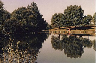
Boggart Hole Clough is a large woodland and urban country park in Blackley, a suburb of Manchester, England. It occupies an area of approximately 76 hectares, part of an ancient woodland, with picturesque cloughs varying from steep ravines to sloping gullies. Clough is a local dialect word for a steep sided, wooded valley. Boggart Hole Clough was designated a Local Nature Reserve in 2008.

Rimer is an unincorporated community in western Sugar Creek Township, Putnam County, Ohio, United States. It lies along State Route 189 between Fort Jennings and Vaughnsville.
Lafayette is a census-designated place (CDP) between the cities of Roanoke and Christiansburg in eastern Montgomery County, southwest Virginia, United States. The population as of the 2010 Census was 449. It is located adjacent to Elliston, at the confluence of the North and South Forks of the Roanoke River.

Wiąg is a village in the administrative district of Gmina Świecie, within Świecie County, Kuyavian-Pomeranian Voivodeship, in north-central Poland. It lies approximately 6 kilometres (4 mi) east of Świecie, 45 km (28 mi) north of Toruń, and 50 km (31 mi) north-east of Bydgoszcz.
Bay Ridge is an unincorporated community in Northampton County, Virginia, United States.
Krasieniec Zakupny is a village in the administrative district of Gmina Iwanowice, within Kraków County, Lesser Poland Voivodeship, in southern Poland.
Nowy Dwór is a village in the administrative district of Gmina Szydłowo, within Piła County, Greater Poland Voivodeship, in west-central Poland.
Wikielec is a settlement in the administrative district of Gmina Iława, within Braniewo County, Warmian-Masurian Voivodeship, in northern Poland, close to the border with the Kaliningrad Oblast of Russia. It lies approximately 3 kilometres (2 mi) west of Braniewo and 81 km (50 mi) north-west of the regional capital Olsztyn.
Bartki is a settlement in the administrative district of Gmina Dąbrówno, within Ostróda County, Warmian-Masurian Voivodeship, in northern Poland.

Hylo is a hamlet in northern Alberta, Canada within Lac La Biche County. It is located approximately 16 kilometres (9.9 mi) south of Highway 55 and 133 kilometres (83 mi) west of Cold Lake.

San Miguel de Urcuquí Canton, or Urkuki, is a canton of Ecuador, located in the Imbabura Province. Its seat is the town of Urcuquí. Its population in the 2001 census was 14,381 and was 15,671 in the 2010 census. The area of the canton is 779 square kilometres (301 sq mi).

Hurricane Mesa is a Utah landform near Hurricane, Utah, used for Cold War tests of rocket ejection seats for supersonic aircraft at the Hurricane Supersonic Research Site. The mesa is "flat bedrock of faultless Shinarump conglomerate" 1,500 ft (460 m) above the Virgin River valley, which allowed clearance for assessment of a longer flight trajectory up from the mesa and over the cliff for the test object.
Flirtation Peak is a summit in Clear Creek County, Colorado, in the United States. It has an elevation of 8,260 feet (2,520 m).

Towneley Colliery or Towneley Desmesne was a coal mine on the Burnley Coalfield in Burnley, Lancashire, England. Sunk in the late 1860s, it was linked to the Lancashire and Yorkshire Railway's Burnley to Todmorden line which became known as the Copy Pit route and, by tramway, to the Leeds and Liverpool Canal.

Habermehl Rock is the rock off the north coast of Livingston Island in the South Shetland Islands, Antarctica 37 m long in southeast–northwest direction and 18 m wide, with a surface area of 0.02 ha. The vicinity was visited by early 19th century sealers.
