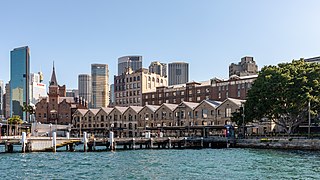
The Rocks is a suburb, tourist precinct and historic area of Sydney's city centre, in the state of New South Wales, Australia. It is located on the southern shore of Sydney Harbour, immediately north-west of the Sydney central business district.

Ku-ring-gai Council is a local government area in Northern Sydney, in the state of New South Wales, Australia. The area is named after a fictional Aboriginal language group.

Windsor is a historic town in north-west of Sydney, New South Wales, Australia. It is the council seat of the Hawkesbury local government area. The town sits on the Hawkesbury River, enveloped by farmland and Australian bush. Many of the oldest surviving European buildings in Australia are located at Windsor. It is 56 km (35 mi) north-west of the Sydney CBD, on the fringes of urban sprawl.

The City of Blue Mountains is a local government area of New South Wales, Australia, governed by the Blue Mountains City Council. The city is located in the Blue Mountains, on the Great Dividing Range at the far western fringe of the Greater Sydney area. Major settlements include, Katoomba, Lawson, Springwood and Blaxland.

The City of Campbelltown is a local government area in the Macarthur region of south-western Sydney, in New South Wales, Australia. The area is located about 55 kilometres (34 mi) south west of the Sydney central business district and comprises 312 square kilometres (120 sq mi).
Mosman Council is a local government area on the Lower North Shore of Sydney, New South Wales, Australia.

The City of Penrith is a local government area in the state of New South Wales, Australia. The seat of the city is located in Penrith, located within Sydney about 50 kilometres (31 mi) west of Sydney central business district. It occupies part of the traditional lands of the Darug people. First incorporated as a municipality on 12 May 1871, on 1 January 1949, the municipalities of Penrith, St Marys and Castlereagh and part of the Nepean Shire amalgamated to form a new Municipality of Penrith. Penrith was declared a City on 21 October 1959, and expanded westwards to include Emu Plains and Emu Heights, formerly part of the City of Blue Mountains, on 25 October 1963. As of the 2021 census the City of Penrith had an estimated population of 217,664.

Woollahra Municipal Council is a local government area in the eastern suburbs of Sydney, in the state of New South Wales, Australia. Woollahra is bounded by Sydney Harbour in the north, Waverley Council in the east, Randwick City in the south and the City of Sydney in the west.

Millers Point is an inner-city suburb of Sydney, in the state of New South Wales, Australia. It is on the north-western edge of the Sydney central business district, adjacent to The Rocks and is part of the local government area of the City of Sydney.

Tamworth Regional Council is a local government area in the New England region of New South Wales, Australia. The area under administration is located adjacent to the New England Highway and the Main North railway line. It was established in March 2004 through the amalgamation of the former City of Tamworth with surrounding shires of Barraba, Manilla, Nundle and Parry.

The City of Lithgow is a local government area in the Central West region of New South Wales, Australia. The area is located adjacent to the Great Western Highway and the Main Western railway line.

Sussex Street is a street in the central business district of Sydney in New South Wales, Australia. It runs north-south along the western side of the city, between Hickson Road and Hay Street. It is in the local government area of the City of Sydney. The street is 1.7 kilometres (1.1 mi) long. It was named in honour of Prince Augustus Frederick, Duke of Sussex, the sixth son of King George III.
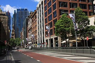
York Street is a street in the Sydney central business district in New South Wales, Australia. York Street runs 1.050 kilometres (0.652 mi) in a north to south direction only and is used predominantly by buses from the northern districts of Sydney.

The Church and Watt Street Terrace Group is a heritage-listed precinct along Church and Watt Streets, Newcastle, City of Newcastle, New South Wales, Australia. It was added to the New South Wales State Heritage Register on 2 April 1999.
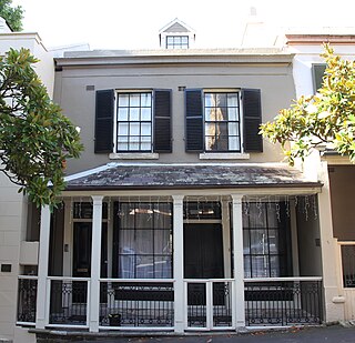
82–84 Windmill Street, Millers Point is a heritage-listed residence and former residence and office located at 82–84 Windmill Street, in the inner city Sydney suburb of Millers Point in the City of Sydney local government area of New South Wales, Australia. It is also known as the Royal College of Pathologists (former) and Terrace. It was added to the New South Wales State Heritage Register on 2 April 1999.

18–20a Munn Street is a heritage-listed row of terrace houses located at 18, 18a, 20, 20a Munn Street, in the inner city Sydney suburb of Millers Point in the City of Sydney local government area of New South Wales, Australia. It was added to the New South Wales State Heritage Register on 2 April 1999.
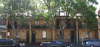
The Eagleton Terrace are heritage-listed terrace houses located at 67–73 Lower Fort Street, in the inner city Sydney suburb of Millers Point in the City of Sydney local government area of New South Wales, Australia. The property was added to the New South Wales State Heritage Register on 2 April 1999.

39–41 Lower Fort Street, Millers Point is a heritage-listed former terrace house and now mixed use located at 39–41 Lower Fort Street, in the inner city Sydney suburb of Millers Point in the City of Sydney local government area of New South Wales, Australia. It is also known as Georgian Townhouse. It was added to the New South Wales State Heritage Register on 2 April 1999.

28 Lower Fort Street, Millers Point is a heritage-listed former residence and now boarding house at 28 Lower Fort Street, in the inner city Sydney suburb of Millers Point in the City of Sydney local government area of New South Wales, Australia. The property was added to the New South Wales State Heritage Register on 2 April 1999.

