
The Ganges is a trans-boundary river of Asia which flows through India and Bangladesh. The 2,525 km (1,569 mi) river rises in the western Himalayas in the Indian state of Uttarakhand. It flows south and east through the Gangetic plain of North India, receiving the right-bank tributary, the Yamuna, which also rises in the western Indian Himalayas, and several left-bank tributaries from Nepal that account for the bulk of its flow. In West Bengal state, India, a feeder canal taking off from its right bank diverts 50% of its flow southwards, artificially connecting it to the Hooghly River. The Ganges continues into Bangladesh, its name changing to the Padma. It is then joined by the Jamuna, the lower stream of the Brahmaputra, and eventually the Meghna, forming the major estuary of the Ganges Delta, and emptying into the Bay of Bengal. The Ganges–Brahmaputra–Meghna system is the second-largest river on earth by discharge.

The Nile is a major north-flowing river in northeastern Africa. It flows into the Mediterranean Sea. The Nile is the longest river in Africa and has historically been considered the longest river in the world, though this has been contested by research suggesting that the Amazon River is slightly longer. Of the world's major rivers, the Nile is one of the smallest, as measured by annual flow in cubic metres of water. About 6,650 km (4,130 mi) long, its drainage basin covers eleven countries: the Democratic Republic of the Congo, Tanzania, Burundi, Rwanda, Uganda, Kenya, Ethiopia, Eritrea, South Sudan, Republic of the Sudan, and Egypt. In particular, the Nile is the primary water source of Egypt, Sudan and South Sudan. Additionally, the Nile is an important economic river, supporting agriculture and fishing.

The Rhine is one of the major European rivers. The river begins in the Swiss canton of Graubünden in the southeastern Swiss Alps. It forms part of the Swiss-Liechtenstein, Swiss-Austrian, and Swiss-German borders. After that the Rhine defines much of the Franco-German border, after which it flows in a mostly northerly direction through the German Rhineland. Finally in Germany, the Rhine turns into a predominantly westerly direction and flows into the Netherlands where it eventually empties into the North Sea. It drains an area of 9,973 sq km and its name derives from the Celtic Rēnos. There are also two German states named after the river, North Rhine-Westphalia and Rhineland-Palatinate.

The Rio Grande in the United States or the Río Bravo in Mexico is one of the principal rivers in the southwestern United States and in northern Mexico. The length of the Rio Grande is 1,896 miles (3,051 km), making it the 4th longest river in the United States and in North America by main stem. It originates in south-central Colorado, in the United States, and flows to the Gulf of Mexico. The Rio Grande drainage basin (watershed) has an area of 182,200 square miles (472,000 km2); however, the endorheic basins that are adjacent to and within the greater drainage basin of the Rio Grande increase the total drainage-basin area to 336,000 square miles (870,000 km2).

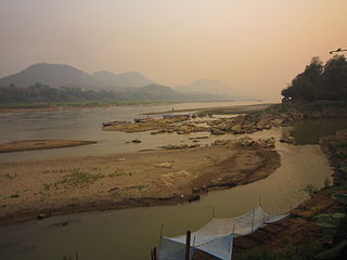
The Mekong or Mekong River is a trans-boundary river in East Asia and Southeast Asia. It is the world's twelfth-longest river and the third-longest in Asia with an estimated length of 4,909 km (3,050 mi) and a drainage area of 795,000 km2 (307,000 sq mi), discharging 475 km3 (114 cu mi) of water annually. From its headwaters in the Tibetan Plateau, the river runs through Southwest China, Myanmar, Laos, Thailand, Cambodia, and southern Vietnam. The extreme seasonal variations in flow and the presence of rapids and waterfalls in the Mekong make navigation difficult. Even so, the river is a major trade route between western China and Southeast Asia. The construction of hydroelectric dams along the Mekong in recent decades causes serious problems for the river's ecosystem, including the exacerbation of drought.
A tributary, or affluent, is a stream or river that flows into a larger stream or main stem river or a lake. A tributary does not flow directly into a sea or ocean. Tributaries and the main stem river drain the surrounding drainage basin of its surface water and groundwater, leading the water out into an ocean. The Irtysh is a chief tributary of the Ob river and is also the longest tributary river in the world with a length of 4,248 km (2,640 mi). The Madeira River is the largest tributary river by volume in the world with an average discharge of 31,200 m3/s (1.1 million cu ft/s).

A distributary, or a distributary channel, is a stream that branches off and flows away from a main stream channel, a phenomenon known as river bifurcation. A distributary is effectively the opposite of a tributary, which is a stream that flows towards and into another stream or river. Distributaries are often found where a stream approaches a lake or an ocean; as such, they are a common feature of river deltas. They can also occur inland, on alluvial fans, or where a tributary stream bifurcates as it nears its confluence with a larger stream. In some cases, a minor distributary can divert so much water from the main channel that it can later become the main route.

The Brahmaputra is a trans-boundary river which flows through Tibet (China), Northeastern India, and Bangladesh. It is known as Brahmaputra or Luit in Assamese,Yarlung Tsangpo in Tibetan, the Siang/Dihang River in Arunachali and Jamuna River in Bengali. It is the 9th largest river in the world by discharge, and the 15th longest.

The Red River, or sometimes the Red River of the South, is a major river in the Southern United States. It was named for its reddish water color from passing through red-bed country in its watershed. It is known as the Red River of the South to distinguish it from the Red River of the North, which flows between Minnesota and North Dakota into the Canadian province of Manitoba. Although once a tributary of the Mississippi River, the Red River is now a tributary of the Atchafalaya River, a distributary of the Mississippi that flows separately into the Gulf of Mexico. This confluence is connected to the Mississippi River by the Old River Control Structure.

A weir or low-head dam is a barrier across the width of a river that alters the flow characteristics of water and usually results in a change in the height of the river level. Weirs are also used to control the flow of water for outlets of lakes, ponds, and reservoirs. There are many weir designs, but commonly water flows freely over the top of the weir crest before cascading down to a lower level. There is no single definition as to what constitutes a weir, and one English dictionary simply defines a weir as a small dam.
An oxbow lake is a U-shaped lake or pool that forms when a wide meander of a river is cut off, creating a free-standing body of water. In South Texas, oxbows left by the Rio Grande are called resacas. In Australia, oxbow lakes are called billabongs. The word "oxbow" can also refer to a U-shaped bend in a river or stream, whether or not it is cut off from the main stream.

The Snowy River is a major river in south-eastern Australia. It originates on the slopes of Mount Kosciuszko, Australia's highest mainland peak, draining the eastern slopes of the Snowy Mountains in New South Wales, before flowing through the Alpine National Park and the Snowy River National Park in Victoria and emptying into Bass Strait.
In hydrology, discharge is the volumetric flow rate of water transported through a given cross-sectional area. It includes any suspended solids, dissolved chemicals, or biologic material in addition to the water itself. Terms may vary between disciplines. For example, a fluvial hydrologist studying natural river systems may define discharge as streamflow, whereas an engineer operating a reservoir system may equate it with outflow, contrasted with inflow.

Teesta River is a 414 km (257 mi) long river that rises in the Pauhunri Mountain of eastern Himalayas, flows through the Indian states of Sikkim and West Bengal and subsequently enters Bangladesh through Rangpur division. In Bangladesh, it falls into Brahmaputra River which after meeting some other major rivers of Bengal delta finally falls into the Bay of Bengal. It drains an area of 12,540 km2 (4,840 sq mi). In India, it flows through Mangan District, Gangtok District, Pakyong District, Kalimpong district, Darjeeling District, Jalpaiguri District, Cooch Behar districts and the cities of Rangpo, Jalpaiguri and Mekhliganj. In Bangladesh, it flows through Lalmonirhat District, Rangpur District, Kurigram District and Gaibandha District. It joins the Brahmaputra River at Phulchhari Upazila in Bangladesh. 305 km (190 mi) of the river lies in India and 109 km (68 mi) in Bangladesh. Teesta is the largest river of Sikkim and second largest river of West Bengal after the Ganges.

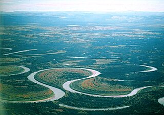
A meander is one of a series of regular sinuous curves in the channel of a river or other watercourse. It is produced as a watercourse erodes the sediments of an outer, concave bank and deposits sediments on an inner, convex bank which is typically a point bar. The result of this coupled erosion and sedimentation is the formation of a sinuous course as the channel migrates back and forth across the axis of a floodplain.

In geography, a confluence occurs where two or more flowing bodies of water join to form a single channel. A confluence can occur in several configurations: at the point where a tributary joins a larger river ; or where two streams meet to become the source of a river of a new name ; or where two separated channels of a river rejoin at the downstream end.

A stream is a continuous body of surface water flowing within the bed and banks of a channel. Depending on its location or certain characteristics, a stream may be referred to by a variety of local or regional names. Long, large streams are usually called rivers, while smaller, less voluminous and more intermittent streams are known as streamlets, brooks or creeks.

A river is a natural flowing watercourse, usually a freshwater stream, flowing on the surface or inside caves towards another waterbody at a lower elevation, such as an ocean, sea, bay, lake, wetland, or another river. In some cases, a river flows into the ground or becomes dry at the end of its course without reaching another body of water. Small rivers can be referred to by names such as creek, brook, and rivulet. There are no official definitions for the generic term river as applied to geographic features, although in some countries or communities, a stream is defined by its size. Many names for small rivers are specific to geographic location; examples are "run" in some parts of the United States, "burn" in Scotland and Northeast England, and "beck" in Northern England. Sometimes a river is defined as being larger than a creek, but not always; the language is vague.

A river mouth is where a river flows into a larger body of water, such as another river, a lake/reservoir, a bay/gulf, a sea, or an ocean. At the river mouth, sediments are often deposited due to the slowing of the current, reducing the carrying capacity of the water. The water from a river can enter the receiving body in a variety of different ways. The motion of a river is influenced by the relative density of the river compared to the receiving water, the rotation of the Earth, and any ambient motion in the receiving water, such as tides or seiches.
