
Botswana is a landlocked country located in Southern Africa, north of South Africa. Botswana occupies an area of 581,730 square kilometres (224,610 sq mi), of which 566,730 km2 (218,820 sq mi) are land. Botswana has land boundaries of combined length 4,347.15 kilometres (2,701.19 mi), of which the constituent boundaries are shared with Namibia, for 1,544 km (959 mi); South Africa 1,969 km (1,223 mi); Zimbabwe, 834 km (518 mi) and Zambia, 0.15 km (0.093 mi). Much of the population of Botswana is concentrated in the eastern part of the country.

Zimbabwe is a landlocked country in southern Africa lying wholly within the tropics. It straddles an extensive high inland plateau that drops northwards to the Zambezi valley where the border with Zambia is and similarly drops southwards to the Limpopo valley and the border with South Africa. The country has borders with Botswana 813 km, Mozambique 1,231 km, South Africa 225 km, Zambia 797 km and almost meets Namibia at its westernmost point.

The Limpopo River rises in South Africa, and flows generally eastwards through Mozambique to the Indian Ocean. The term Limpopo is derived from Rivombo (Livombo/Lebombo), a group of Tsonga settlers led by Hosi Rivombo who settled in the mountainous vicinity and named the area after their leader. The river is approximately 1,750 kilometres (1,087 mi) long, with a drainage basin 415,000 square kilometres (160,200 sq mi) in size. The mean discharge measured over a year is 170 m3/s at its mouth. The Limpopo is the second largest river in Africa that drains to the Indian Ocean, after the Zambezi River.

The San Joaquin River is the longest river of Central California. The 366-mile (589 km) long river starts in the high Sierra Nevada, and flows through the rich agricultural region of the northern San Joaquin Valley before reaching Suisun Bay, San Francisco Bay, and the Pacific Ocean. An important source of irrigation water as well as a wildlife corridor, the San Joaquin is among the most heavily dammed and diverted of California's rivers.

Limpopo is the northernmost province of South Africa. It is named after the Limpopo River, which forms the province's western and northern borders. The capital and largest city in the province is Polokwane.

The Los Gatos Creek runs 24 miles (39 km) in California through Santa Clara Valley Water District's Guadalupe Watershed from the Santa Cruz Mountains northward through the Santa Clara Valley until its confluence with the Guadalupe River in downtown San Jose. The Guadalupe River then continues onward into San Francisco Bay.

The Shashe River is a major left-bank tributary of the Limpopo River in Zimbabwe. It rises northwest of Francistown, Botswana and flows into the Limpopo River where Botswana, Zimbabwe and South Africa meet. The confluence is at the site of the Greater Mapungubwe Transfrontier Conservation Area.

The Notwane River is a river in southeastern Botswana. Certain sections of its course form the international boundary with South Africa. Its mouth is at the head of the Limpopo River. It has a catchment area of 18,053 square kilometers.

The Lotsane River is a river in southeastern Botswana. It is a seasonal left hand tributary of the Limpopo River and has a catchment area of 9,748 square kilometers.

Tsetsebjwe is a village in the Bobirwa sub-district of the Central District of Botswana. It is in the Central Bobonong census district. As of 2001 it had a population of 4,396. The village is northwest of the privately owned Limpopo-Lipadi Game and Wilderness Reserve, near the South African border.

The Motloutse River is a river in Botswana, a tributary of the Limpopo River. The catchment area is 19,053 square kilometres (7,356 sq mi). The Letsibogo Dam on the Motloutse has been built to serve the industrial town of Selebi-Phikwe and surrounding local areas, with potential for use in irrigation.
The Letsibogo Dam is a dam on the Motloutse River in Botswana, built to initially provide water to the industrial town of Selebi-Phikwe and surrounding local areas, with potential for use in irrigation. The dam now supplies Gaborone, the capital of the country, via a 400 kilometres (250 mi) pipeline, as well as major villages along the pipeline route.
The Bokaa Dam is a dam on the Metsimotlhabe River, a tributary of the Ngotwane River, in Botswana. It provides water to the capital city of Gaborone. It is operated by the Water Utilities Corporation.
The Nnywane Dam is a dam on the Nnywane River in Botswana. The reservoir provides a water supply to Lobatse, a town 70 kilometres (43 mi) south of Gaborone. Water from the reservoir may also be transferred to Gaborone if needed.
The Metsimotlhabe River is the largest river in the Kweneng District of Botswana, draining the area that lies to the south of Molepolole into the Notwane River, in turn a tributary of the Limpopo River. The name "Metsimotlhabe" means "water sand river".
The Dikgatlhong Dam is a dam near the village of Robelela on the Shashe River in Botswana, completed in December 2011. When full it will hold 400,000,000 cubic metres (1.4×10¹⁰ cu ft). The next largest dam in Botswana, the Gaborone Dam, has capacity of 141,000,000 cubic metres (5.0×10⁹ cu ft).
Mmamabula is a planned coal mine and coal-fired power station to the east of the main road and rail corridor in Botswana between Gaborone and Francistown and south of the Serorome River. The power station would be near to the village of Mmaphashalala. It is about 130 kilometres (81 mi) north of the capital city of Gaborone.
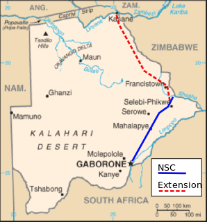
The North-South Carrier (NSC) is a pipeline in Botswana that carries raw water south for a distance of 360 kilometres (220 mi) to the capital city of Gaborone. Phase 1 was completed in 2000. Phase 2 of the NSC, under construction, will duplicate the pipeline to carry water from the Dikgatlhong Dam, which was completed in 2012. A proposed extension to deliver water from the Zambezi would add another 500 to 520 kilometres to the total pipeline length. The NSC is the largest engineering project ever undertaken in Botswana.

The Waterberg Coalfield is an extensive deposit of coal in the Ellisras Basin in South Africa, lying mostly in the Waterberg District Municipality of the Limpopo province. Mining is increasing, both for export and for local power production, and industry in the region is expected to expand. This may have significant impact on the dry and fragile Limpopo basin ecosystems.
Mmamashia is a location in Botswana about 15 kilometres (9.3 mi) north of the capital city of Gaborone that is the site of the Mmamashia water treatment plant and master balancing reservoir.
