Booby's Bay

Last updated

Booby's Bay Booby's Bay - geograph.org.uk - 7536.jpg
Booby's Bay
The wreck of the SV Carl Wreck Carl of Hamburg - panoramio.jpg
The wreck of the SV Carl

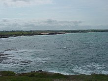
Booby's Bay is a sandy beach near Padstow, Cornwall, England, UK. [1] [2] The beach is wide with many rock pools. It is completely covered by high tide and is popular with surfers, though may be dangerous for the amateur. There is a lifeguard on duty during the summer, but the water is often red-flagged. Access to the beach is by climbing down from the coast path or walking along the beach at low tide. Dogs are allowed on the beach all year round. Booby's Bay has no beach at the highest tides, the ribs of a wrecked ship appear periodically as the sand is relocated by the sea and prevailing currents. During World War I the three masted sailing ship Carl of the German navy was beached and abandoned in Constantine Bay while being towed to London during a storm. [3]

Related Research Articles

<span class="mw-page-title-main">Cawsand</span> Human settlement in England

Cawsand and Kingsand are twin villages in southeast Cornwall, England, United Kingdom. The village is situated on the Rame Peninsula and is in the parish of Maker-with-Rame.

<span class="mw-page-title-main">Mount's Bay</span> Bay on the south coast of Cornwall, England

Mount's Bay is a bay on the English Channel coast of Cornwall, England, stretching from the Lizard Point to Gwennap Head. In the north of the bay, near Marazion, is St Michael's Mount; the origin of name of the bay. In summer, it is a generally benign natural harbour. However, in winter, onshore gales present maritime risks, particularly for sailing ships. There are more than 150 known wrecks from the nineteenth century in the area. The eastern side of the bay centred around Marazion and St Michael's Mount was designated as a Marine Conservation Zone in January 2016.

<span class="mw-page-title-main">Fistral Beach</span> Beach on the north coast of Cornwall, England

<span class="mw-page-title-main">Readymoney Cove</span> Beach near the town of Fowey, United Kingdom

Readymoney Cove is a sandy beach to the south of the harbour town of Fowey, Cornwall, England, United Kingdom. It is sheltered by cliffs close to the mouth of the River Fowey estuary and bounded, on one side, by the medieval part of the town of Fowey and, on the other, by St Catherine's Castle. The beach can be covered during spring tides. The beach is cleaned daily during high season, and a bathing platform is moored in the bay. There is a small shop with public toilet facilities both of which are open all year round. Dogs are banned between 10am and 6pm during July and August. Above the cove is the former coach house which was the home of author, Daphne du Maurier, for a few years during the Second World War. Comedian Dawn French used to live in a house overlooking the cove.

<span class="mw-page-title-main">Treyarnon</span>

<span class="mw-page-title-main">Gunwalloe</span> Human settlement in England

Gunwalloe is a coastal civil parish in Cornwall, England, United Kingdom. It is situated on the Lizard Peninsula three miles (4.8 km) south of Helston and partly contains The Loe, the largest natural freshwater lake in Cornwall. The parish population including Berepper at the 2011 census was 219. The hamlets in the parish are Chyanvounder, Berepper and Chyvarloe. To the east are the Halzephron cliffs and further east the parish church.

<span class="mw-page-title-main">Carnewas and Bedruthan Steps</span> Coastline and cliffs in Cornwall, United Kingdom

Carnewas and Bedruthan Steps is a stretch of coastline located on the north Cornish coast between Padstow and Newquay, in Cornwall, England, United Kingdom. It is within the parish of St Eval and is part-owned by the National Trust. The trust maintains a shop and café, and the cliff–top views of rocks stretching into the distance along Bedruthan beach make the area a popular attraction for tourists and painters. The property affords walks along the coast path and the steep steps at Bedruthan allow access to a series of rocky beaches at low tide. Signs at the top of the steps down to the beaches warn visitors not to risk swimming in these waters due to heavy rips, fast tides, and submerged rocks.

<span class="mw-page-title-main">St Anthony Head</span>

<span class="mw-page-title-main">Nanjizal</span> Bay in Cornwall, UK

Nanjizal, also known as Mill Bay, is a beach and cove in the civil parish of St Levan, Cornwall, on the south-western coast of Great Britain. Situated one mile to the south-east of Land's End, Nanjizal has no direct access via road, and is usually reached via the South West Coast Path from Land's End in the north, or from Porthgwarra to the south. Nanjizal is also a noted bird watching location.

<span class="mw-page-title-main">Daymer Bay</span> Bay and beach in north Cornwall, England

<span class="mw-page-title-main">Whitesand Bay</span> Land mass in Cornwall, England

Whitesand Bay is a wide sandy bay near Land's End in west Cornwall, England, United Kingdom. It stretches for one mile between the headlands of Pedn-mên-du and Aire Point. and contains the village of Sennen Cove. It is also a landing point for the Atlantic Crossing 1 international telecommunications cable.

<span class="mw-page-title-main">Vault Beach</span>

Vault Beach is situated on the south coast of Cornwall, England, UK, near Gorran Haven. The beach consists mainly of shingle but does have some sand at low tide. Vault Beach faces southeast onto the English Channel and lies between Cadythew Rocks in the north and Dodman Point at the southern end.

<span class="mw-page-title-main">Holywell, Cornwall</span> Village in Cornwall, England

<span class="mw-page-title-main">Mawgan Porth</span>

Mawgan Porth is a beach and small settlement in north Cornwall, England. It is north of Watergate Bay, approximately four miles (6 km) north of Newquay, on the Atlantic Ocean coast.

<span class="mw-page-title-main">Downderry</span> Human settlement in England

Downderry is a coastal village in southeast Cornwall, England, United Kingdom. It is situated 12 miles (19 km) west of Plymouth and one mile east of Seaton.

<span class="mw-page-title-main">Tregirls</span>

<span class="mw-page-title-main">Brea Hill</span> Hill in Cornwall, England

<span class="mw-page-title-main">Kerthen Wood</span> Hamlet in Cornwall, England

Kerthen Wood, or Kirthen Wood, is a hamlet near Townshend in Cornwall, England. It is in the civil parish of Crowan

<span class="mw-page-title-main">Portholland</span> Human settlement in the United Kingdom

Portholland is a settlement in Cornwall, England, UK. It is on the south coast in the civil parish of St Michael Caerhays. The name Portholland comes from the Cornish language elements porth, meaning 'cove' or 'harbour', and Alan, a personal name.

<span class="mw-page-title-main">Kennack Sands</span> Beach in Cornwall, England

Kennack Sands is a beach and sand-dune system on the east coast of the Lizard Peninsula, Cornwall, England, UK.

References

  1. Ordnance Survey: Landranger map sheet 200 Newquay & Bodmin (Camelford & St Austell) (Map). Ordnance Survey. ISBN   978-0-319-22938-5.
  2. "Ordnance Survey: 1:50,000 Scale Gazetteer" (csv (download)). www.ordnancesurvey.co.uk. Ordnance Survey. 1 January 2016. Retrieved 30 January 2016.
  3. Lettens, Jan. "Carl [+1917]". wrecksite. Retrieved 15 April 2012.

50°32′21″N5°01′36″W / 50.5392°N 5.0268°W / 50.5392; -5.0268