This article needs additional citations for verification .(November 2020) |
The Boone Trail is a marked trail between Virginia Beach, Virginia and San Francisco, California, laid to honour the travels of U.S. explorer Daniel Boone.
This article needs additional citations for verification .(November 2020) |
The Boone Trail is a marked trail between Virginia Beach, Virginia and San Francisco, California, laid to honour the travels of U.S. explorer Daniel Boone.
Between 1913 and 1938, Joseph Hampton Rich, a resident of Mocksville, North Carolina, placed 358 metal tablets between Virginia Beach, Virginia and San Francisco, California, in honor of Daniel Boone and his travels. Although many of the tablets are associated with locations visited by Boone, many were simply placed wherever Rich could collect the necessary donations from schools and communities to erect a monument. He established the Boone Trail Highway Association to further his project. From the mid-1920s to the mid-1930s, the Association published a newsletter detailing the efforts to install new monuments.

The tablets were (at least partially) constructed from metal salvaged from the battleship USS Maine (ACR-1),[ citation needed ] sunk during the Spanish–American War in 1898. The tablets were typically located near schools, government buildings, or along old highway routes. Over the years, many of the markers have been lost to highway construction and urban sprawl.
In the late-1990s, a group of descendants of Daniel Boone established the Boone Trail Highway & Memorial Re-Association with the intent of locating the markers which remained. Approximately 60 tablets have been located so far.[ citation needed ] One of the tablets can be found on Franklin Street in Chapel Hill, North Carolina. Another can be found in front of historic Old Main on the campus of The University of North Carolina at Pembroke in Pembroke, North Carolina.

U.S. Route 101, or U.S. Highway 101 (US 101), is a north–south United States Numbered Highway that traverses the states of California, Oregon, and Washington on the West Coast of the United States. It travels for over 1,500 miles (2,400 km), primarily along the Pacific Ocean, and is also known by various names, including El Camino Real in parts of California, the Oregon Coast Highway, and the Olympic Highway in Washington. Despite its three-digit number, normally used for spur routes, US 101 is classified as a major route in the United States Numbered Highway System.

U.S. Route 1 or U.S. Highway 1 (US 1) is a major north–south United States Numbered Highway that serves the East Coast of the United States. It runs 2,370 miles (3,810 km) from Key West, Florida, north to Fort Kent, Maine, at the Canadian border, making it the longest north–south road in the United States. US 1 is generally paralleled by Interstate 95 (I-95), though US 1 is significantly farther west and inland between Jacksonville, Florida, and Petersburg, Virginia, while I-95 is closer to the coastline. In contrast, US 1 in Maine is much closer to the coast than I-95, which runs farther inland than US 1. The route connects most of the major cities of the East Coast from the Southeastern United States to New England, including Miami, Jacksonville, Augusta, Raleigh, Richmond, Washington, D.C., Baltimore, Philadelphia, Newark, New York City, New Haven, Providence, Boston, and Portland.

The Lincoln Highway is one of the first transcontinental highways in the United States and one of the first highways designed expressly for automobiles. Conceived in 1912 by Indiana entrepreneur Carl G. Fisher, and formally dedicated October 31, 1913, the Lincoln Highway runs coast-to-coast from Times Square in New York City west to Lincoln Park in San Francisco. The full route originally ran through 13 states: New York, New Jersey, Pennsylvania, Ohio, Indiana, Illinois, Iowa, Nebraska, Colorado, Wyoming, Utah, Nevada, and California. In 1915, the "Colorado Loop" was removed, and in 1928, a realignment routed the Lincoln Highway through the northern tip of West Virginia. Thus, there are 14 states, 128 counties, and more than 700 cities, towns, and villages through which the highway passed at some time in its history.
The League of American Bicyclists (LAB), officially the League of American Wheelmen, is a membership organization that promotes cycling for fun, fitness and transportation through advocacy and education. A Section 501(c)(3) nonprofit organization, the League is one of the largest membership organizations of cyclists in the United States.

The Blue Ridge Parkway is a National Parkway and All-American Road in the United States, noted for its scenic beauty. The parkway, which is the longest linear park in the U.S., runs for 469 miles (755 km) through 29 counties in Virginia and North Carolina, linking Shenandoah National Park to Great Smoky Mountains National Park. It runs mostly along the spine of the Blue Ridge, a major mountain chain that is part of the Appalachian Mountains. Its southern terminus is at U.S. Route 441 (US 441) on the boundary between Great Smoky Mountains National Park and the Qualla Boundary of the Eastern Band of Cherokee Indians in North Carolina, from which it travels north to Shenandoah National Park in Virginia. The roadway continues through Shenandoah as Skyline Drive, a similar scenic road which is managed by a different National Park Service unit. Both Skyline Drive and the Virginia portion of the Blue Ridge Parkway are part of Virginia State Route 48 (SR 48), though this designation is not signed.

El Camino Real is a 600-mile (965-kilometer) commemorative route connecting the 21 Spanish missions in California, along with a number of sub-missions, four presidios, and three pueblos. Historically associated with the Calle Real which terminates in Mexico City, as the former capital of New Spain and the seat of royal power for Las Californias, its southern end in the modern U.S. state of California is at Mission San Diego de Alcalá and its northern terminus is at Mission San Francisco Solano.

U.S. Route 50 or U.S. Highway 50 (US 50) is a major east–west route of the U.S. Highway system, stretching 3,019 miles (4,859 km) from Interstate 80 (I-80) in West Sacramento, California, to Maryland Route 528 in Ocean City, Maryland, on the Atlantic Ocean. Until 1972, when it was replaced by Interstate Highways west of the Sacramento area, it extended to San Francisco, near the Pacific Ocean. The Interstates were constructed later and are mostly separate from this route. It generally serves a corridor south of I-70 and I-80 and north of I-64 and I-40.

U.S. Route 421 is a diagonal northwest–southeast United States Numbered Highway in the states of North Carolina, Tennessee, Virginia, Kentucky, and Indiana. The highway runs for 941 miles (1,514 km) from Fort Fisher, North Carolina, to US 20 in Michigan City, Indiana. Along its routing, US 421 serves several cities including Wilmington, North Carolina; Greensboro, North Carolina; Bristol, Tennessee and Virginia; Lexington, Kentucky; and Indianapolis, Indiana. US 421 is a spur route of US 21, which it meets west of Yadkinville, North Carolina.
There are many historic trails and roads in the United States which were important to the settlement and development of the United States including those used by American Indians.

The Wilderness Road was one of two principal routes used by colonial and early national era settlers to reach Kentucky from the East. Although this road goes through the Cumberland Gap into southern Kentucky and northern Tennessee, the other is sometimes called the "Cumberland Road" because it started in Fort Cumberland in Maryland. Despite Kentucky Senator Henry Clay's advocacy of this route, early in the 19th century, the northern route was selected for the National Road, connecting near Washington, Pennsylvania into the Ohio Valley of northern Kentucky and Ohio.
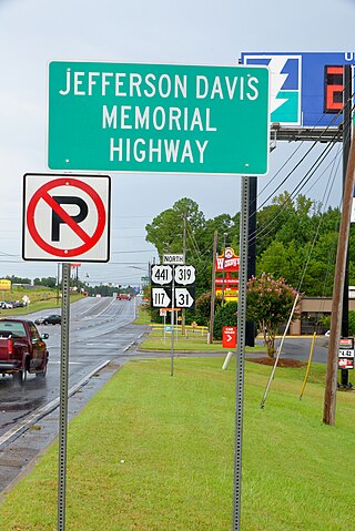
The Jefferson Davis Highway, also known as the Jefferson Davis Memorial Highway, was a transcontinental highway in the United States in the 1910s and 1920s that began in Arlington, Virginia, and extended south and west to San Diego, California; it was named for Jefferson Davis, President of the Confederate States, United States senator, and Secretary of War. Because of unintended conflict between the National Auto Trail movement and the federal government, it is unclear whether it ever really existed in the complete form that its United Daughters of the Confederacy (UDC) founders originally intended.

The Lee Highway was a national auto trail in the United States, connecting New York City and San Francisco, California, via the South and Southwest.

A commemorative plaque, or simply plaque, or in other places referred to as a historical marker, historic marker, or historic plaque, is a plate of metal, ceramic, stone, wood, or other material, typically attached to a wall, stone, or other vertical surface, and bearing text or an image in relief, or both, to commemorate one or more persons, an event, a former use of the place, or some other thing. Many modern plaques and markers are used to associate the location where the plaque or marker is installed with the person, event, or item commemorated as a place worthy of visit. A monumental plaque or tablet commemorating a deceased person or persons, can be a simple form of church monument. Most modern plaques affixed in this way are commemorative of something, but this is not always the case, and there are purely religious plaques, or those signifying ownership or affiliation of some sort. A plaquette is a small plaque, but in English, unlike many European languages, the term is not typically used for outdoor plaques fixed to walls.
The Arrowhead Trail or Arrowhead Highway was the first all-weather road in the Western United States that connected Los Angeles, California with Salt Lake City, Utah by way of Las Vegas, Nevada. Built primarily during the auto trails period of the 1910s, prior to the establishment of the United States Numbered Highway System, the road was replaced in 1926 by U.S. Route 91 (US 91) and subsequently Interstate 15 (I-15). Small portions of the route in California, Nevada and Utah are sometimes still referred to by the name, or as Arrow Highway.

State Route 168 is a primary state highway in the South Hampton Roads region of the U.S. state of Virginia. It runs from the border with North Carolina through the independent cities of Chesapeake and Norfolk where it ends in the Ocean View area near the Hampton Roads Bridge-Tunnel.
Note: A fully interactive online map of the Lincoln Highway and all of its re-alignments, markers, monuments and historic points of interest can be viewed at the Lincoln Highway Association Official Map website.

The Old Spanish Trail was an auto trail that once spanned the United States with almost 2,750 miles (4,430 km) of roadway from ocean to ocean. It crossed eight states and 67 counties along the southern border of the United States. Work on the auto highway began in 1915 at a meeting held at the Battle House Hotel in Mobile, Alabama; and, by the 1920s, the trail linked St. Augustine, Florida, to San Diego, California, with its center and headquarters in San Antonio, Texas. The work at San Antonio, and indeed nationally, was overseen by an executive committee consisting of prominent San Antonio businessmen which met at the Gunter Hotel weekly.
A total of fifteen special routes of U.S. Route 101 exist.

The La Playa Trail was a historic bayside trail in San Diego, connecting the settled inland areas to the commercial anchorage at Old La Playa on San Diego Bay. The La Playa Trail has been recognized as the oldest commercial trail in the Western United States. The trail was used during the Pre-Hispanic, Spanish, Mexican and American periods of San Diego history. Much of the length of the original trail corresponds to the current Rosecrans Street in the San Diego neighborhood of Point Loma. There are eight registered National Historic Districts and 70 identified historic sites along the trail, according to the La Playa Trail Association, which was formed in 2005 to recognize the historic nature of the trail and to honor the many different peoples who traveled along it.
| | This North Carolina–related article is a stub. You can help Wikipedia by expanding it. |