Boonton Gorge

Last updated
Rockaway River water falls in the gorge Boonton Falls - panoramio.jpg
Rockaway River water falls in the gorge

The Boonton Gorge is a river gorge in Boonton, New Jersey where the Rockaway River drops over several waterfalls, and travels for slightly over a mile before emptying into the Jersey City Reservoir.

Contents

Geology

Beginning of the Boonton Gorge,
the old Morris Canal dam Old Morris Canal Dam, Boonton, NJ.jpg
Beginning of the Boonton Gorge,
the old Morris Canal dam

The Rockaway River flows through flat plains of Denville and Boonton Township. At this point elevation is 480 feet (150 m) above sea level. The Rockaway River spills over a man-made dam that is six feet high in the town of Boonton. This is the beginning of the Boonton Gorge. This location is the Grace Lord Park at this point. This is where the Rockaway River begins its descent over the Ramapo Fault.

During the late Triassic Period when the North American Plate separated from the African Plate, an aborted rift system was created between the Ramapo Fault and a fault west of Paterson. A half graben was created and was filled with red bed sediment. The land between the Ramapo fault and the fault west of Paterson lowered, thus the Boonton Gorge was born.

The river flows over rocks then cascades over a thirty foot water fall [1] into an oval shaped pool of water with a rock in the center. This pool is about fifty yards long and was a swimming hole until a local ordinance prohibited swimming in 1990 (Ord. 205-5). [2] Then the river drops over a small falls of about seven feet and flows under an arched stone walk-way bridge. This is called the arch bridge. The river flows fast and drops into the second pool of water which is not as wide as the first pool above. The water moves at a medium pace through this oval shaped pool before it starts its non-stop descent to the Jersey City Reservoir. At the end of the second pool, the river narrows. The water picks up speed and starts its descent through iron ore rock. There are several rocks that are pointed, one behind the other. The river goes under a railroad bridge and then slows a little for about a hundred yards, when it drops over a three foot concrete USGS gauging station weir. [3] Soon the river flows under Route 287. The river then follows the east side of Route 287. At this point the river drops forty feet in a quarter of a mile, when it finally empties into the Jersey City Reservoir. The final descent is through a boulder garden. [4]

Before the Jersey City Reservoir was built, a dam was built on the Rockaway River in the late 1920s. [5] The rapids would have continued for another half mile. The rapids would have stopped in Parsippany. At this point the elevation is two hundred twenty feet above sea level. Before the dam was built, the river dropped a total of two hundred sixty feet in a mile and a half.

There is a huge boulder of about fifteen feet high that sits near the arch bridge. It is known locally as "Indian Rock" though it has also been known as "Washington Rock" in the past. [6] There is a huge metal ring at the top of the boulder.

Hiking

Stone Arch Bridge over the Rockaway River Stone Arch Bridge, Boonton, NJ.jpg
Stone Arch Bridge over the Rockaway River

Boonton Gorge contains a small, but well developed trail system for fishing access as well as recreation. Trails provide views of the river and waterfalls. The trails on either side of the river are connected over the stone arch bridge, built in the 19th century. Historical Markers at some points highlight remains of the local iron industry which operated there in the 19th century. At two points along the trails, near the falls, there are yellow "Riverphones" for calling emergency responders in the event of an accident. These were installed in 1997 as part of a Boy Scout Project and are now administered by the Boonton Fire Dept. [7]

After 2011's Hurricane Irene, the righthand hiking trail (across the river from Main Street) eroded into a 85-ft drop. [8]

Fishing and canoeing

Rapids in the Boonton Gorge above the stone arch bridge Rapids in the Boonton Gorge, NJ.jpg
Rapids in the Boonton Gorge above the stone arch bridge

The New Jersey Fish and Game stock the river with rainbow and brown trout several times a year in the spring. Stockings are on Mondays from early April to late May. The water is swift and there are a lot of snags, which can make the fishing challenging.

Though local authorities have recently discouraged kayaking and canoeing in Boonton Gorge, [9] there is no local ordinance or state law prohibiting these activities [2] and it has been a popular class IV-V whitewater run for many years. [10] [11] [12] Whitewater paddlers generally begin above the stone arch bridge and paddle down to the gauging station or the edge of the Jersey City Reservoir. [11] This section of river drops at a rate of approximately 120 feet per mile. [10] The river can be paddled from 2.7 ft (0.82 m). up to 5 ft (1.5 m). on the gauge. At a gauge reading of 2.7-3.2 ft, the river is a shallow and rocky and is rated class 3+ on the International Scale of River Difficulty. [13] From 3.2 to 4 feet (1.2 m) it is rated class 4, and from 4 to 5 feet (1.5 m) on the gage it is rated class 5. [10] [11] At 5 feet (1.5 m) on the gage the river is considered in flood flowing at two thousand cubic feet a second. [14] At higher levels this section of river should only be attempted by paddlers very comfortable on class 5 whitewater. [11] [13] Some local residents view this river section as extremely dangerous, [15] and there have been two reported drownings in recent decades, one a teenage male swimmer in 1990 [ citation needed ], and the other a young boy who fell into the river at high water in 1996. [7] There do not seem to be any verified reports of drownings involving canoeing, kayaking, tubing or rafting in Boonton Gorge since enthusiasts began running it in the 1970s. [12] [16]

It has been reported that in the very early 1970s, 4 youths went down the gorge in tire tubes and 2 drowned as they were not wearing life vests [ citation needed ].

Related Research Articles

<span class="mw-page-title-main">Boonton, New Jersey</span> Town in Morris County, New Jersey, United States

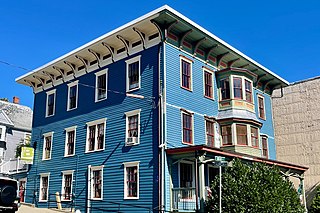
Boonton is a town in Morris County, in the U.S. state of New Jersey. As of the 2020 United States census, the town's population was 8,815, an increase of 468 (+5.6%) from the 2010 census count of 8,347, which in turn reflected a decline of 149 (−1.8%) from the 8,496 counted in the 2000 census. The settlement was originally called "Boone-Towne" in 1761 in honor of the Colonial Governor Thomas Boone.

<span class="mw-page-title-main">Passaic River</span> River in New Jersey, United States

Passaic River is a river, approximately 80 miles (130 km) long, in Northern New Jersey. The river in its upper course flows in a highly circuitous route, meandering through the swamp lowlands between the ridge hills of rural and suburban northern New Jersey, called the Great Swamp, draining much of the northern portion of the state through its tributaries.

<span class="mw-page-title-main">Rockaway River</span> River in New Jersey, United States

The Rockaway River is a tributary of the Passaic River, approximately 35 mi (56 km) long, in northern New Jersey in the United States. The upper course of the river flows through a wooded mountainous valley, whereas the lower course flows through the populated New Jersey suburbs and former industrial area west of New York City. It drains an area of approximately 130 sq mi (340 km²).

<span class="mw-page-title-main">Watauga River</span> River in the United States of America

The Watauga River is a large stream of western North Carolina and East Tennessee. It is 78.5 miles (126.3 km) long with its headwaters in Linville Gap to the South Fork Holston River at Boone Lake.

<span class="mw-page-title-main">Doe River</span> Tributary of the Watauga River in northeast Tennessee, United States

The Doe River is a tributary of the Watauga River in northeast Tennessee in the United States. The river forms in Carter County near the North Carolina line, just south of Roan Mountain State Park, and flows to Elizabethton.

<span class="mw-page-title-main">Farmington River</span> River in the United States of America

The Farmington River is a river, 46.7 miles (75.2 km) in length along its main stem, located in northwest Connecticut with major tributaries extending into southwest Massachusetts. The longest route of the river, from the origin of its West Branch, is 80.4 miles (129.4 km) long, making it the Connecticut River's longest tributary by 2.3 miles (3.7 km) over the major river directly to its north, the Westfield River. The Farmington River's watershed covers 609 square miles (1,580 km2). Historically, the river played an important role in small-scale manufacturing in towns along its course, but it is now mainly used for recreation and drinking water.

<span class="mw-page-title-main">Augsburg Eiskanal</span>

The Augsburg Eiskanal is an artificial whitewater river in Augsburg, Germany, constructed as the canoe slalom venue for the 1972 Summer Olympics in nearby Munich.

<span class="mw-page-title-main">Deerfield River</span> River in Vermont and Massachusetts, United States

Deerfield River is a river that runs for 76 miles (122 km) from southern Vermont through northwestern Massachusetts to the Connecticut River. The Deerfield River was historically influential in the settlement of western Franklin County, Massachusetts, and its namesake town. It is the Connecticut River's second-longest tributary in Massachusetts, 2.1 miles (3.4 km) shorter than Metropolitan Springfield's Westfield River.

<span class="mw-page-title-main">Green River (North Carolina)</span> Stream in North Carolina, USA

The Green River is a dam-release river that flows through the mountains of North Carolina, south of Asheville. The Green has numerous tributaries, but much of its water flows from a confluence with Big Hungry Creek. The Green River is itself a tributary of the Broad River. The river is dammed to form Lake Summit, in Tuxedo, North Carolina, and Lake Adger near Mill Spring, NC. The Green River is named for its deep green color but runs brown after heavy rains.

<span class="mw-page-title-main">Kettle River (St. Croix River tributary)</span> River in Minnesota, United States

The Kettle is an 83.6-mile-long (134.5 km) tributary of the St. Croix River in eastern Minnesota in the United States. Via the St. Croix River, it is part of the watershed of the Mississippi River. The river's English name is due to the large number of large rounded holes (kettles) in the sandstone in and around the river, carved out by the swirling waters of the river. The river's Dakota name Céġa watpa entered into English via the Anishinaabe people's Akiko-ziibi, both meaning "Kettle River".

<span class="mw-page-title-main">Tallulah Gorge State Park</span>

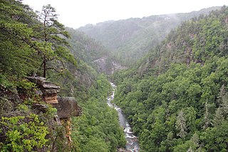
Tallulah Gorge State Park is a 2,689-acre (1,088 ha) Georgia state park adjacent to Tallulah Falls, Georgia, along the county line between Rabun and Habersham Counties. The park surrounds Tallulah Gorge, a 1,000-foot (300 m) deep gorge formed by the action of the Tallulah River, which runs along the floor of the gorge. The major attractions of the gorge are the six waterfalls known as the Tallulah Falls, which cause the river to drop 500 feet over one mile.

<span class="mw-page-title-main">U.S. National Whitewater Center</span> Sports venue in North Carolina, United States of America

The U.S. National Whitewater Center (USNWC) is a not-for-profit outdoor recreation and athletic training facility for whitewater rafting, kayaking, canoeing, rock climbing, mountain biking hiking and ice skating which opened to the public on 2006. The Center is located in Charlotte, North Carolina on approximately 1,300 acres (530 ha) of land adjacent to the Catawba River, with more than 50 miles (80 km) of developed trail.

<span class="mw-page-title-main">Hertford Castle Weir</span> Weir on the River Lea in Hertfordshire, England

<span class="mw-page-title-main">Upper Dart</span>

Upper Dart is a section of the River Dart, Dartmoor. It is perhaps the second most popular section of whitewater for kayakers and canoeists in England, particularly for experienced paddlers. This section is followed on by the Dart Loop.

Splitrock Reservoir is 1,500 acres (610 ha) of wilderness, surrounding a 650 acre reservoir, located on the borders of Rockaway Township and Kinnelon, in Morris County, New Jersey, United States. Splitrock, along with the nearby Boonton Reservoir, provides water for Jersey City, New Jersey. The reservoir is surrounded by woods and can be reached by traveling a mile on a dirt road known as Split Rock Road. The reservoir is three miles from end to end, with many large islands. There is a man-made dam on the southwest end of the reservoir. The reservoir and surrounding natural area were opened to the public on November 21, 2003.

<span class="mw-page-title-main">Dickerson Whitewater Course</span> Artificial whitewater course in Maryland, United States

The Dickerson Whitewater Course, on the Potomac River near Dickerson, Maryland, was built for use by canoe and kayak paddlers training for the 1992 Olympic Games in Spain. It was the first pump-powered artificial whitewater course built in North America, and is still the only one anywhere with heated water. It remains an active training center for whitewater slalom racing, swiftwater rescue training, and other whitewater activities.

<span class="mw-page-title-main">Troy Meadows</span>

Troy Meadows is a 3,100-acre (1,300 ha) nature preserve in Parsippany, Morris County, New Jersey. Along with the Great Swamp, it is one of the remnants of Glacial Lake Passaic. It was designated a National Natural Landmark in 1967. It is the largest freshwater marsh in New Jersey, the Whippany River goes through the swamp before connecting with the Rockaway River. It is part of the Northeastern coastal forests ecoregion.

<span class="mw-page-title-main">Boonton Reservoir</span> Reservoir in New Jersey, US

The Boonton Reservoir is a 700-acre (280 ha) reservoir located between Boonton and Parsippany–Troy Hills, New Jersey. Boonton, along with nearby Splitrock Reservoir, provides water for Jersey City, New Jersey. It was formed by the construction of a dam on the Rockaway River completed in 1904 on the site of the original town of Boonton.

<span class="mw-page-title-main">Arch Bridge from the Boonton Ironworks</span> Historic bridge in New Jersey, United States

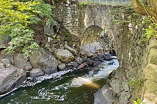
The Arch Bridge from the Boonton Ironworks crosses the Rockaway River in Grace Lord Park in the town of Boonton in Morris County, New Jersey. The single-span fieldstone arch bridge was built by John Carson Sr. in 1866 to carry a water pipe to the ironworks. It was added to the National Register of Historic Places on September 1, 2022, for its significance in engineering. It is currently used as a pedestrian bridge.

References

  1. Bud Light still has a stronghold over the American beer market. Based on year-to-date data, it is still the top-selling beer in the United States. It also sells more beer by volume than any other brand.
  2. 1 2 "Boonton Municipal Code online". Town of Boonton, NJ. Retrieved 9 Nov 2010.
  3. "Realtime stream gauge for Rockaway river above the reservoir at Boonton". USGS. Retrieved 10 Nov 2010.
  4. "American Whitewater: Rockaway River, Boonton Gorge Page". American Whitewater. Retrieved 9 Nov 2010.
  5. Neill-Hancock, Jane. "Rapids and Waterfall, Boonton Gorge, Rockaway River, Boonton". Red Bubble. Retrieved 10 July 2012.
  6. "Historical Boonton postcards". BoontonPostcards.comule.com. Retrieved 11 Nov 2010.
  7. 1 2 Daily Record, 8-28-2004, Peggy Wright, "Boonton firefighters rescue woman who jumped in river", Morris, NJ, pg.A.15
  8. "Boonton residents divided on $2M Grace Lord Park repairs".
  9. Daily Record, Jun 29, 2006, TEHANI SCHNEIDER; "Capsized kayakers rescued in Boonton"; Morris ,NJ, pg. 1
  10. 1 2 3 Edward Gertler [1992], Garden State Canoeing: A Paddlers Guide to New Jersey, The Seneca Press, Pg. 182-3, ISBN   0-9605908-5-4
  11. 1 2 3 4 "American Whitewater: Rockaway River, Boonton Gorge Page". American Whitewater. Retrieved 9 Nov 2010.
  12. 1 2 Ed Hanrahan, March–June 1979, "Breaking Ice on the Boonton Gorge", American Whitewater: The Journal of the American Whitewater Affiliation, Volume XXIV, NO. 2-3, page 10
  13. 1 2 "International Scale of River Difficulty". American Whitewater. Retrieved 9 Nov 2010.
  14. "Middle Atlantic River Forecast Center". National Weather Service. Retrieved 10 Nov 2010.
  15. Neighbor News, 2-14-2007, Lisa Kintish, "Whitewater section of Rockaway River could be off limits to paddlers", Boonton, NJ
  16. "Whitewater Accident Database". American Whitewater. Retrieved 9 Nov 2010.

40°54′27″N74°25′07″W / 40.907519°N 74.418517°W / 40.907519; -74.418517