
Boorabbin National Park is a national park in Western Australia, between Coolgardie and Southern Cross. It is located along the Great Eastern Highway for a distance of approximately 25 km with a width of 5 km on each side in Western Australia's eastern goldfields. The park gets its name from the Aboriginal named rock on the edge of the park and also the Boorabbin settlement, established in 1898.

Toodyay, known as Newcastle between 1860 and 1910, is a town on the Avon River in the Wheatbelt region of Western Australia, 85 kilometres (53 mi) north-east of Perth. The first European settlement occurred in the area in 1836. After flooding in the 1850s, the townsite was moved to its current location in the 1860s. It is connected by railway and road to Perth. During the 1860s, it was home to bushranger Moondyne Joe.

Cottesloe is a western suburb of Perth, Western Australia, within the Town of Cottesloe. Cottesloe was named for Thomas Fremantle, 1st Baron Cottesloe, a prominent Tory politician and the brother of Admiral Sir Charles Fremantle for whom the city of Fremantle was named. The nearby suburb of Swanbourne was named for the Fremantle family seat, Swanbourne House, in Swanbourne, Buckinghamshire.

Eyre Highway is a 1,664-kilometre (1,034 mi) highway linking Western Australia and South Australia via the Nullarbor Plain. Signed as National Highways 1 and A1, it forms part of Highway 1 and the Australian National Highway network linking Perth and Adelaide. It was named after explorer Edward John Eyre, who was the first European to cross the Nullarbor by land, in 1840–1841. Eyre Highway runs from Norseman in Western Australia, past Eucla, to the state border. Continuing to the South Australian town of Ceduna, it crosses the top of the Eyre Peninsula before reaching Port Augusta.

Southern Cross is a town in Western Australia, 371 kilometres east of state capital Perth on the Great Eastern Highway. It was founded in 1888 after gold prospectors Richard Greaves and Ted Paine during their October 1887 expedition successfully found gold, and gazetted in 1890. It is the major town and administrative centre of the Shire of Yilgarn. At the 2016 census, Southern Cross had a population of 680.
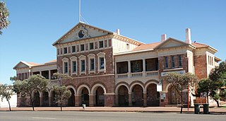
Coolgardie is a small town in Western Australia, 558 kilometres (347 mi) east of the state capital, Perth. It has a population of approximately 850 people.

Brunswick Junction is a town in the South West of Western Australia, situated along the South Western Highway between Harvey and Bunbury. It had a population of 772 people at the 2016 census, down from 797 at the 2006 census.
The Eastern Goldfields Railway was built in the 1890s by the Western Australian Government Railways to connect Perth with the Eastern Goldfields at Coolgardie and Kalgoorlie.

Boya is a locality on the Darling Scarp, in the Shire of Mundaring, Western Australia; it is on the south side of Greenmount Hill, and just west of Darlington.

Woodanilling is a small town in the Great Southern region of Western Australia.

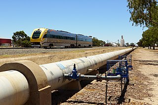
The Goldfields Water Supply Scheme is a pipeline and dam project that delivers potable water from Mundaring Weir in Perth to communities in Western Australia's Eastern Goldfields, particularly Coolgardie and Kalgoorlie. The project was commissioned in 1896 and completed in 1903.

Yornaning is a small town located in the Wheatbelt region of Western Australia, on Great Southern Highway, between Pingelly and Narrogin.
Helena Vale was the original name for Midland Junction in Western Australia between 1885 and 1901. It was also the earlier name of the Midland Junction Municipality between 1895 and 1901. The name has been long associated with the area between Midland and the Darling Scarp.
Queen Victoria Street is the main road entering the city centre of Fremantle, Western Australia, from the direction of Perth. The road was originally named Cantonment Road, but was subsequently renamed Victoria Road, and a few years later Queen Victoria Street, after Queen Victoria of the United Kingdom, to avoid confusion with similarly named roads in the area.
Boolardy Station is a remote former sheep and cattle station in the Mid West (Murchison) region of Western Australia, about 194 km (121 mi) north-north-east of Pindar and 200 km (120 mi) west-south-west of Meekatharra. It is within the Shire of Murchison and situated on pastoral lease no. 3114/406. The area of the lease is 3,467.48 square kilometres (1,338.80 sq mi).
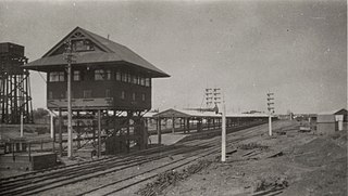
Kalgoorlie railway station is the easternmost attended station in Western Australia, located at the eastern terminus of the Eastern Goldfields Railway. It serves the city of Kalgoorlie. Beyond Kalgoorlie, the line continues east as the Trans-Australian Railway.

Forrest Highway is a 95-kilometre-long (59 mi) highway in Western Australia's Peel and South West regions, extending Perth's Kwinana Freeway from east of Mandurah down to Bunbury. Old Coast Road was the original Mandurah–Bunbury route, dating back to the 1840s. Part of that road, and the Australind Bypass around Australind and Eaton, were subsumed by Forrest Highway. The highway begins at Kwinana Freeway's southern terminus in Ravenswood, continues around the Peel Inlet to Lake Clifton, and heads south to finish at Bunbury's Eelup Roundabout. There are a number of at-grade intersections with minor roads in the shires of Murray, Waroona, and Harvey including Greenlands Road and Old Bunbury Road, both of which connect to South Western Highway near Pinjarra.

Clackline is a locality in the Wheatbelt region of Western Australia, about 80 kilometres (50 mi) east-north-east of Perth.
Railway dams and reservoirs were used to supply water to an extensive railway system that ventured into low rainfall, and poor water quality areas of the inner regions of Western Australia in the 1890s.
Old Eyre Highway is a remnant part of the Eyre Highway that was abandoned in the construction of a route closer to the coast of the Great Australian Bight.