Booué

Last updated
Booué
Mbue from the Shiwe language
Town
Booue March 1878.jpg
Booué, March 1878, shortly before the town was founded
Gabon location map.svg
Red pog.svg
Booué
Location in Gabon
Coordinates: 00°06′00″S11°56′00″E / 0.10000°S 11.93333°E / -0.10000; 11.93333
Country Flag of Gabon.svg Gabon
Province Ogooué-Ivindo Province
Department Lope Department

Booué is a small town in central Gabon. It is situated in Lopé Department, southwest side of the Ogooué-Ivindo Province. The town lies just 6.6 miles to the south of the Equator and is the province's only Department capital in the Southern Hemisphere.

Gabon country in Africa

Gabon, officially the Gabonese Republic, is a country on the west coast of Central Africa. Located on the equator, Gabon is bordered by Equatorial Guinea to the northwest, Cameroon to the north, the Republic of the Congo on the east and south, and the Gulf of Guinea to the west. It has an area of nearly 270,000 square kilometres (100,000 sq mi) and its population is estimated at 2 million people. Its capital and largest city is Libreville.

Lopé (department) Department in Ogooué-Ivindo Province, Gabon

Lopé is the southwestern department of Ogooué-Ivindo Province and is in the center of Gabon. The capital lies at Booué. This is the department with the most land in the Southern Hemisphere.

Ogooué-Ivindo Province Province in Gabon

The Ogooué-Ivindo province is the northeastern-most of Gabon's nine provinces, though its Lopé Department is in the very center of the country. The regional capital is Makokou, which is home to one-third of the provincial population. It gets its name from two rivers, the Ogooué and the Ivindo. This province is the largest, least populated, and least developed of the nine.

Contents

History

Booué is a bad transcription and a francization effort of the word "Mbue" or "Mboue" from the Shiwe language erroneously attributed to a town located in Ogooué-Ivindo province, Gabon by Pierre Savorgnan de Brazza in 1878. Booué is still referred to as "Mboue" by the Shiwe people who were the first settlers of this town and who named it Nangashiki, but was changed to Mboue and subsequently to Booué. From all historical accounts, this change resulted from a miscommunication between De Brazza and Mpami Nani Shui, a Shiwe Chief, during some negotiation talks between the two men. Many accounts from the Shiwe people indicate that while negotiating his passage to the upper Ogooué River, De Brazza asked Mpami Nani Shui the name of his village. Thinking that De Brazza was actually asking the name of an aquatic plant floating on the Ogooué River, he answered "Mboung" as the Shiwe people called it. De Brazza, thinking that he had been told the actual name of the village, wrote and recorded it as "Mboue", then Booué later on. Thus Mboue, as a village and later a town, was founded by the Shiwe people originating from the southeast of Cameroon between the eighteenth and nineteenth centuries; but the name Mboue itself and later its transcription "Booué" was mistakenly attributed to the village and later to the town by De Brazza. During the French colonization, Mboue was the capital city of the then Ogooué-Ivindo region until 1953. Today, it is just one of the four Department capital cities of the Ogooué-Ivindo Province.

Francization or Francisation, Frenchification, or Gallicization designates the extension of the French language by its adoption as a first language or not, adoption that can be forced upon or desired by the concerned population.

Pierre Savorgnan de Brazza Italian explorer

Pietro Paolo Savorgnan di Brazzà, then known as Pierre Paul François Camille Savorgnan de Brazza, was an Italian explorer. With the backing of the Société de Géographie de Paris, he opened up for France entry along the right bank of the Congo that eventually led to French colonies in Central Africa. His easy manner and great physical charm, as well as his pacific approach among Africans, were his trademarks. Under French colonial rule, the capital of the Republic of the Congo was named Brazzaville after him and the name was retained by the post-colonial rulers.

Ogooué River river

The Ogooué, some 1,200 kilometres (750 mi) long, is the principal river of Gabon in west central Africa and the fourth largest river in Africa by volume of discharge, trailing only the Congo, Niger and Zambezi. Its watershed drains nearly the entire country of Gabon, with some tributaries reaching into the Republic of the Congo, Cameroon, and Equatorial Guinea.

Transport

Visitors from other parts of Gabon and from overseas use generally the TRANSGABONAIS trains to get to Booué. It is perhaps the cheapest and safest way to travel to Booué, but it also can be very tiring and time-consuming. Booué does have an airfield; but it may not be very practical because it is not tarred. In addition, air tickets may be very expensive since there is no regular airline serving this town. Visitors from other cities in the Ogooué-Ivindo province generally use rented mini buses, cars, and trucks to travel to Booué. Once in Booué, there are some local cabs to get around. If one is interested in crossing the Ogooué River for an adventure in the bush, a ferry is available at no cost; but you will need a car for the ferry to make the trip!

See also

Related Research Articles

Mékambo Place in Ogooué-Ivindo Province, Gabon

Mékambo is a small town in north-eastern Gabon on the banks of the Zadié river. It is located in the Ogooué-Ivindo province of Gabon and is the seat of the Zadié Department. It has received international press for recent outbreaks of Ebola hemorrhagic fever in 1994 and 1997.

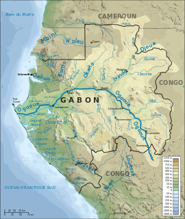
The Ivindo River is the most important tributary of the Ogooué River, which flows in Gabon.

Ogooué-Lolo Province Province in Gabon

The Ogooué-Lolo Province is one of the nine provinces of Gabon, slightly southeast of central Gabon. The regional capital is Koulamoutou, a city of approximately 16,000 people. It is the ninth largest city in Gabon and the home of slightly more than one-third of the provincial population.

Lambaréné Place in Moyen-Ogooué, Gabon

Lambaréné is a town and the capital of Moyen-Ogooué in Gabon. With a population of 38,775 as of 2013, it is located 75 kilometres south of the equator.

Trans-Gabon Railway railway in Gabon

The Trans-Gabon Railway is the only railway in Gabon. It runs 670 km east from Owendo port station in Libreville to Franceville via numerous stations, the main ones being Ndjolé, Lopé, Booué, Lastoursville and Moanda.

Ndjolé Place in Moyen-Ogooué Province, Gabon

Ndjolé is the capital town in the Abanga-Bigne Department in Gabon, lying northeast of Lambaréné on the Ogooué River, the N2 road and the Trans-Gabon Railway. It is known as a base for logging and as a transport hub. Ndjolé is the last city that can be reached by barge traffic traveling up the Ogooué River. Above Ndjolé there are rapids on the river.

Haut-Ogooué Province Province in Gabon

Haut-Ogooué is the southeastern-most of Gabon's nine provinces. It is named after the Ogooué River. It covers an area of 36,547 km². The provincial capital is Franceville. One of its primary industries is mining, with manganese, gold and uranium being found in the region. The uranium-bearing mineral Francevillite takes its name from the primary city. It is the historical home of three cultures, the Obamba, Ndzabi and Téké. Like many regions in Africa, more traditional uses of the land have given way to rural migration to the larger cities. In August 2006, its soccer club won the Gabon Independence Cup.

Moyen-Ogooué Province Province in Gabon

Moyen-Ogooué is one of Gabon's nine provinces. It covers an area of 18,535 km2 (7,156 sq mi). The provincial capital is Lambaréné.

Ngounié Province Province in Gabon

Ngounié is a province of south-central Gabon covering an area of 3,775 kilometres (2,346 mi). Its capital is Mouila. At the 2013 census it had 100,838 inhabitants. In 2016, its governor was Benjamin Nzigou.

Woleu-Ntem Province Province in Gabon

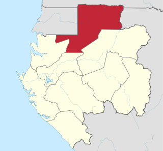
Woleu-Ntem is the northernmost of Gabon's nine provinces. It covers an area of 38,465 km² and named after Woleu and Ntem rivers that cross it. The provincial capital is Oyem, which had a total of 60,685 inhabitants in 2013.

Departments of Gabon

The provinces of Gabon are divided into forty-nine departments. The departments are listed below, by province :

The Batéké Plateau is located around the border between the Republic of Congo and Gabon. In both countries it gave name to departments:

Zadié (department) Department in Ogooué-Ivindo Province, Gabon

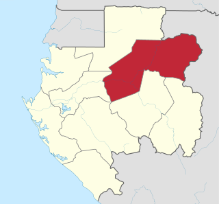
Zadié is a department of Ogooué-Ivindo Province in northern-eastern Gabon. The capital lies at Mékambo. As of 2003 the department had a population of 15,203 people. The department has a population of Bakoya pygmies, settled here since about 1933 along the main roads from Mékambo to Mazingo and Mékambo to Ekata on the Congolese border. The area received international press for outbreaks of Ebola hemorrhagic fever in 1994 and 1997.

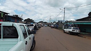
Shiwe, also known as "Fang Makina", is a Bantu language of central Gabon, near the related language Yambe. It is most closely related to Kwasio. The Gabonese people who refer themselves as Shiwe or Bishiwe live in the city of Booué in the Ogooué-Ivindo province. There are no accurate statistics available for the Shiwe population in Booué. However, there are about 18 Shiwe tribes still living in Booué today. These tribes include Bi-mbouma, Bira-ngouembi, Bi-néli, Sha-ntouong, Sha-nguié, Bi-nshwô, Bi-shanga, Bi-kwo, Bi-tsinguie’rg, Sha-shouo, Bi-nvœ’rg, Bi-koundeu, Biong-nkouendi, Bi-ntoubi, Biékoulembi, Bi-nzimili, Bi-nyambi, Sha-tsoung. These tribes live in 5 villages including Beleumeu, Menchoung, Metououng, Beaux Arts, and Tsombiali. It is important to underline that there are entire Shiwe tribes and villages near Makokou and Ndjole. But these originally Shiwe tribes are now increasingly using more the Fang language than Shiwe.

The Bakoya are pygmies, earlier known as Négrilles or Babinga, who inhabitant the rainforest between Cameroon and the Great Lake region of the Congo Basin in Central Africa. Since the 1930s, the Bakoya, in particular, have settled in Gabon in the Ogooue-Ivindo Province, in the northeastern region of the country. Similar minority groups are the Babongo and the Baka pygmies. Before they adapted to the agricultural practices in the new settlements in Gabon along the flanks of the road, Bakoya were “semi-nomadic hunter-gatherers” like the other forest-dwelling pygmies; they resided in small huts. The word 'Pygmee' is a French coinage, adopted by the Gabonese. They are the earliest inhabitants of the forest and are nomadic hunter gatherers.

Booué Airport

Booué Airport is an airport serving the town of Booué in the Ogooué-Ivindo Province of Gabon. The runway lies within a bend of the Ogooué River.

The Okandé are a people of north-eastern Gabon who belong to the Mèmbè language group. Their language overlaps that of the Apindzi and the Simba about 80/86% according to professor Van Der Veen. Their estimated population of 2,000 persons live in the Lopé region in Ogooué-Ivindo. The Mwiri, a male initiation institution, still plays an important role in the traditional social and religious life of the Okandé.

References

    Coordinates: 00°06′S11°56′E / 0.100°S 11.933°E / -0.100; 11.933

    Geographic coordinate system Coordinate system

    A geographic coordinate system is a coordinate system that enables every location on Earth to be specified by a set of numbers, letters or symbols. The coordinates are often chosen such that one of the numbers represents a vertical position and two or three of the numbers represent a horizontal position; alternatively, a geographic position may be expressed in a combined three-dimensional Cartesian vector. A common choice of coordinates is latitude, longitude and elevation. To specify a location on a plane requires a map projection.