Related Research Articles

Wayne County is a county in the U.S. state of Nebraska. As of the 2020 census, the population was 9,697. Its county seat is Wayne.
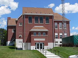
Thurston County is the northeasternmost county in the U.S. state of Nebraska. As of the 2020 United States Census, the population was 6,773. Its county seat is Pender.

Dawes County is a county in the U.S. state of Nebraska. As of the 2020 United States Census, the population was 8,199. Its county seat is Chadron. The county was formed in 1885; it was named for James W. Dawes, the Nebraska Governor at the time.
The Cowboy Trail is a rail trail in northern Nebraska. It is a multi-use recreational trail suitable for bicycling, walking and horseback riding. It occupies an abandoned Chicago and North Western Railway corridor. When complete, the trail will run from Chadron to Norfolk, a length of 321 miles (517 km), making it the longest rails-to-trails conversion in the United States. It is Nebraska's first state recreational trail. The trail runs across the Outback area of Nebraska.
Rock Creek is a 19.1-mile-long (30.7 km) tributary of the Elkhorn River that flows south of Wisner and enters the Elkhorn one mile west of Beemer. The railway water stop and original plats where the village of Beemer is now located were named "Rock Creek" before Beemer was incorporated as a village in 1886.
Irvington is an unincorporated community located just outside the northwest city limits of Omaha, Nebraska. As of 2010, Irvington's estimated population was 451, making it the smallest village in the Greater Omaha Metropolitan area, according to the Nebraska State Historical Society. The community was named for author Washington Irving.
Millerton is an unincorporated community in Butler County, Nebraska, United States.
Arabia is an unincorporated community in Cherry County, Nebraska, United States.

Irwin is an unincorporated community in Cherry County, Nebraska, United States.
Thatcher is an unincorporated community. It is located in Cherry County, Nebraska, United States.
Bordeaux is an unincorporated community in Dawes County, Nebraska, United States.
Stafford is an unincorporated community in Holt County, Nebraska, United States.
Andrews is an unincorporated community in Sioux County, Nebraska, United States.
Glen is an unincorporated community in Sioux County, Nebraska, United States. It was named for the surrounding glen.
Bell Creek is a stream in Washington, Dodge and Burt counties, Nebraska, in the United States.

Boxelder Creek is a stream in Pennington, Meade and Lawrence counties, South Dakota, in the United States. It is a tributary of the Cheyenne River.
Bull Creek is a stream in Pennington County, South Dakota, in the United States. It is a tributary of the Cheyenne River.
Lake Creek is a stream in Calhoun and Pocahontas counties, Iowa, in the United States. It is a tributary of the North Raccoon River.

Eli is an unincorporated community in Cherry County, Nebraska, United States. Its population is approximately 60-75 people, but exact census information has not been collected. It is one mile (1.6 km) north of U.S. Route 20 and 2.5 miles (4.0 km) south of the Nebraska-South Dakota border. The nearest town is Merriman, 11.8 miles (19.0 km) to the west. It is also 12.8 miles (20.6 km) west of Cody.

Verdigre Creek is a stream in Knox and Antelope counties, in the U.S. state of Nebraska.
References
- ↑ U.S. Geological Survey Geographic Names Information System: Bordeaux Creek
- ↑ Chicago and North Western Railway Company (1908). A History of the Origin of the Place Names Connected with the Chicago & North Western and Chicago, St. Paul, Minneapolis & Omaha Railways. p. 45.
42°56′15″N102°59′17″W / 42.937478°N 102.987964°W
| | This article related to a river in Nebraska is a stub. You can help Wikipedia by expanding it. |