
Wookey Hole Caves are a series of limestone caverns, a show cave and tourist attraction in the village of Wookey Hole on the southern edge of the Mendip Hills near Wells in Somerset, England. The River Axe flows through the cave. It is a Site of Special Scientific Interest (SSSI) for both biological and geological reasons. Wookey Hole cave is a "solutional cave", one that is formed by a process of weathering in which the natural acid in groundwater dissolves the rocks. Some water originates as rain that flows into streams on impervious rocks on the plateau before sinking at the limestone boundary into cave systems such as Swildon's Hole, Eastwater Cavern and St Cuthbert's Swallet; the rest is rain that percolates directly through the limestone. The temperature in the caves is a constant 11 °C (52 °F).
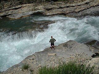
Whitewater forms in the context of rapids, in particular, when a river's gradient changes enough to generate so much turbulence that air is trapped within the water. This forms an unstable current that froths, making the water appear opaque and white.

Ogof Craig a Ffynnon is a cave in Wales. The cave is about 7 km in length and is located at the base of a quarried rockface in the Clydach Gorge. Water flowing out of the cave is a resurgence of water draining off Llangatock Mountain above.
Ogof Ffynnon Ddu, also known informally as OFD, is a cave under a hillside in the area surrounding Penwyllt in the Upper Swansea Valley in South Wales. It is the second longest cave in Wales and the deepest in the United Kingdom.

The Marble Arch Caves are a series of natural limestone caves located near the village of Florencecourt in County Fermanagh, Northern Ireland. The caves are named after the nearby Marble Arch, a natural limestone arch at the upstream end of Cladagh Glen under which the Cladagh River flows. The caves are formed from three rivers draining off the northern slopes of Cuilcagh mountain, which combine underground to form the Cladagh. On the surface, the river emerges from the largest karst resurgence in Ireland, and one of the largest in the United Kingdom. At 11.5 kilometres (7.1 mi) the Marble Arch Caves form the longest known cave system in Northern Ireland, and the karst is considered to be among the finest in the British Isles.
Titan is a natural cavern near Castleton in the Derbyshire Peak District, and is the deepest shaft of any known cave in Britain, at 141.5 metres (464 ft). The existence of Titan was revealed in November 2006, following its discovery on 1 January 1999 after cavers discovered connections from the James Hall Over Engine Mine to both Speedwell Cavern and Peak Cavern. Previously, the deepest known underground shaft in Britain had been Gaping Gill on the slopes of Ingleborough in the Yorkshire Dales.

Eastwater Cavern is a cave near Priddy in the limestone of the Mendip Hills, in Somerset, England. It is also known as Eastwater Swallet. It was first excavated in April 1902 by a team led by Herbert E. Balch composed of paid labourers and volunteers from the Wells Natural History Society. Progress was initially slow, but by February 1903 Balch and Willcox had discovered substantial passage, following the streamway down to the bottom of the cave. Dolphin Pot was dug in 1940 by the Wessex Cave Club, with Primrose Pot following in 1950. West End series was the most recent significant discovery, in 1983.

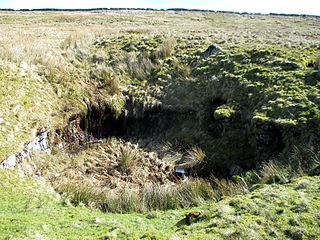
Upper Flood Swallet which was originally known as Blackmoor Flood Swallet, is an exceptionally well-decorated cave near Charterhouse, in the carboniferous limestone of the Mendip Hills, in Somerset, England. The cave is part of the Cheddar Complex SSSI.
Ogof Agen Allwedd or Agen Allwedd, is, at 20.2 miles (32.5 km), one of the longest cave systems in Wales, and the longest cave system on the Llangattock escarpment.
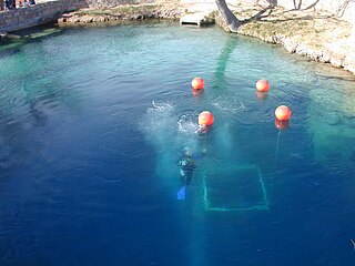
The Blue Hole of Santa Rosa, or simply the Blue Hole, is a circular, bell-shaped pool or small lake located along Route 66 east of Santa Rosa, New Mexico that is a tourist attraction and swimming venue, and one of the most popular dive destinations in the US for scuba diving and training. The Blue Hole is an artesian well and cenote that was once used as a fish hatchery.
Langcliffe Pot is a cave system on the slopes of Great Whernside in Upper Wharfedale, about 3 kilometres (1.9 mi) SSE of Kettlewell in North Yorkshire. It is part of the Black Keld Site of Special Scientific Interest where the "underground drainage system which feeds the stream resurgence at Black Keld is one of the largest and deepest in Britain, although only a small proportion of its cave passages are accessible at present." Mossdale Caverns is also part of the Black Keld SSSI. Although a considerable length of passage has been explored in Langcliffe Pot, the current end is over 170 metres (560 ft) above the resurgence, and over 4 kilometres (2.5 mi) in distance. A trip to the far end has been described as "one of the most serious undertakings in British caving".
Shannon Cave is an active stream passage cave which straddles the border of County Fermanagh, Northern Ireland and County Cavan in the Republic of Ireland.
The Caves of the Tullybrack and Belmore hills are a collection of caves in southwest County Fermanagh, Northern Ireland. The region is also described as the West Fermanagh Scarplands by environmental agencies and shares many similar karst features with the nearby Marble Arch Caves Global Geopark.
The Nidderdale Caves are a series of caves in Upper Nidderdale in North Yorkshire, England. There are two cave systems and most of the caves are in some way linked with one or the other. The smaller system is the Eglin cave system in the valley of How Stean Beck, a tributary of the River Nidd, associated with How Stean Gorge. The larger system is the Goyden cave system under the valley of the River Nidd, which flows east from Scar House Reservoir, then south, and shortly after disappears underground down several sinkholes to reappear at the rising just beyond the village of Lofthouse. Cavers can access several sections of this system via the different entrances.

Short Drop Cave and Gavel Pot are different entrances into the same cave system on Leck Fell, in Lancashire, England. The main top entrance, Short Drop Cave, is a small hole in a fenced-off shakehole near the main stream sink. Gavel Pot, a window into the system, is a large fenced shakehole some 40-metre (130 ft) deep requiring tackle to descend. There are two other smaller entrances into Short Drop Cave. At its base the system links via a sump with Lost Johns' Cave, and is part of the Three Counties System, an 87 kilometres (54 mi) cave system which spans the borders of Cumbria, Lancashire, and North Yorkshire.
Skirwith Cave is a major resurgence solutional cave on Ingleborough in Chapel-le-Dale, North Yorkshire, England; it was a show cave between 1964 and 1974. It is no longer open to the public but is still visited by cavers. It lies within the designated Ingleborough Site of Special Scientific Interest.
There are a number of terms that are used in connection with caves, caving and speleology. The following is an incomplete list.

Death's Head Hole is a cave on Leck Fell, in Lancashire, England. Its entrance is a 64-metre (210 ft) deep shaft. It leads into Lost Johns' Cave and is part of the Three Counties System, an 87-kilometre (54 mi) cave system which spans the borders of Cumbria, Lancashire, and North Yorkshire.
Long Drop Cave is a cave on Leck Fell, in Lancashire, England. It leads into Death's Head Hole, and is part of the Three Counties System, an 87-kilometre (54 mi) cave system which spans the borders of Cumbria, Lancashire, and North Yorkshire.

The Long Kin East Cave - Rift Pot system is a limestone cave system on the southern flanks of Ingleborough, North Yorkshire in England lying within the designated Ingleborough Site of Special Scientific Interest. Long Kin East Cave starts as a long meandering stream passage but then plummets down a 58-metre (190 ft) deep shaft when it meets a shattered fault into which Rift Pot also descends. At the bottom, the stream flows through some low canals and sumps, to eventually emerge at Austwick Beck Head in Crummackdale.
