
Georges-Eugène Haussmann, commonly known as Baron Haussmann, was a French official who served as prefect of Seine (1853–1870), chosen by Emperor Napoleon III to carry out a massive urban renewal programme of new boulevards, parks and public works in Paris commonly referred to as Haussmann's renovation of Paris.

The Gare de Lyon, officially Paris Gare de Lyon, is one of the seven large mainline railway stations in Paris, France. It handles about 148.1 million passengers annually according to the estimates of the SNCF in 2018, with SNCF railways and the RER D accounting for around 110 million and the RER A accounting for 38 million, making it the second-busiest station of France after the Gare du Nord and one of the busiest in Europe.
La Chapelle is a station on Paris Métro Line 2, on the border of the 10th and 18th arrondissements above the Boulevard de la Chapelle. The station is connected to the Gare du Nord and the Gare du Nord Métro station on lines 4 and 5.

The Gare du Nord, officially Paris Nord, is one of the seven large mainline railway station termini in Paris, France. The station is served by trains that run between the capital and northern France via the Paris–Lille railway, as well as to international destinations in Belgium, Germany, the Netherlands and the United Kingdom. Located in the northern part of Paris near the Gare de l'Est in the 10th arrondissement, the Gare du Nord offers connections with several urban transport lines, including Paris Métro, RER and buses. It is the busiest railway station in Europe by total passenger numbers, and the busiest outside Japan. In 2015, the Gare du Nord saw more than 700,000 passengers per day.

Gare de l'Est – Verdun is a station of the Paris Métro, serving Lines 4, 5, and 7 is located in the 10th arrondissement in Paris, France. It is the fifth busiest station on the network.

The Gare de l'Est, officially Paris Est, is one of the seven large mainline railway station termini in Paris, France. It is located in the 10th arrondissement, not far southeast from the Gare du Nord, facing the Boulevard de Strasbourg, part of the north–south axis of Paris created by Georges-Eugène Haussmann.

Magenta station is a station of the Île-de-France Réseau Express Régional (RER), in the 10th arrondissement of Paris, France. Built on the site of the Gare du Nord, the original name of Magenta station was Nord-Est with the possibility of a connection to both Paris-Nord and Paris-Est.
RER E is one of the five lines in the Réseau Express Régional, a hybrid commuter rail and rapid transit system serving Paris and its suburbs. The 60-kilometre (37 mi) line travels between western and eastern suburbs, with all trains serving the stations in central Paris, before branching out towards the ends of the line.

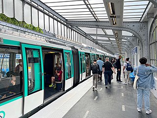
Line 4 is one of the sixteen lines of the Paris Métro rapid transit system and one of its three fully automated lines. Situated mostly within the boundaries of the City of Paris, it connects Porte de Clignancourt in the north and Bagneux-Lucie Aubrac in the south, travelling across the heart of the city. Until its southern terminus was changed from Porte d'Orléans to Mairie de Montrouge in 2013, the line was sometimes referred to as the Clignancourt – Orléans Line. At 13.9 km (8.6 mi) in length, it connects with all Paris Métro lines apart from the very short 3bis and 7bis branch lines, as well as with all 5 RER express lines. It also serves three of the Paris Railway stations, Gare du Nord, Gare de l'Est, and Gare Montparnasse. It is the second-busiest Métro line after Line 1, carrying over 154 million passengers in 2004.

Paris's former Chemin de fer de Petite Ceinture, also colloquially known as La Petite Ceinture, was a circular railway built as a means to supply the city's fortification walls, and as a means of transporting merchandise and passengers between Paris' major rail-company stations. Beginning as two distinct 'Ceinture Syndicate' freight and 'Paris-Auteuil' passenger lines from 1851, these lines formed an arc that surrounded the northern two thirds of Paris, an arc that would become a full circle of rail around the capital when its third Ceinture Rive Gauche section was built in 1867.
Transilien is the brand name given to the commuter rail network serving Île-de-France, the region surrounding and including the city of Paris. The network consists of nine lines: H, J, K, L, N, P, R, U, and V each operated by SNCF, the state-owned French railway company. The lines begin and end in major Parisian stations, except for lines U and V which connect major stations outside the Paris city borders. Unlike the RER network, the Transilien trains do not cross through the Paris city centre.
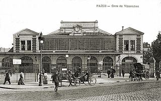
The Gare de la Bastille was a railway station on the Place de la Bastille in the 12th arrondissement of Paris, France. The station was opened in 1859 and served as the terminus of the 55-kilometre (34 mi)-long line to Vincennes and Verneuil-l'Étang. The line was opened only to serve the Fort de Vincennes; it was extended to La Varenne and later to Brie-Comte-Robert. The line finally reached Verneuil-l'Étang in 1892 and connected to the line to Mulhouse. Part of the line was included into the new suburban commuter rail line RER A on 14 December 1969. The station was demolished in 1984 so that the Opéra Bastille could be built.
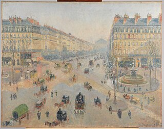
Haussmann's renovation of Paris was a vast public works programme commissioned by French Emperor Napoleon III and directed by his prefect of the Seine, Georges-Eugène Haussmann, between 1853 and 1870. It included the demolition of medieval neighbourhoods that were deemed overcrowded and unhealthy by officials at the time, the building of wide avenues, new parks and squares, the annexation of the suburbs surrounding Paris, and the construction of new sewers, fountains and aqueducts. Haussmann's work was met with fierce opposition, and he was dismissed by Napoleon III in 1870. Work on his projects continued until 1927. The street plan and distinctive appearance of the centre of Paris today are largely the result of Haussmann's renovation.

AREP is a multidisciplinary consultancy that is wholly owned by SNCF. It was formed in 1997 by Jean-Marie Duthilleul and Étienne Tricaud, architects and engineers. It has 600 staff from around 15 countries, including town planners, architects, engineers, economists, technicians, designers, and project managers. Raphaël Ménard, its president since 2018, has announced his intention to make AREP the laboratory for ecological design through the EMC2B approach.

The Boulevard de Sébastopol is an important roadway in Paris, France, which serves to delimit the 1st and 2nd arrondissements from the 3rd and 4th arrondissements of the city.

Pantin is a railway station in Pantin, Seine-Saint-Denis, France. It opened in 1864 on the Paris–Strasbourg railway and Paris–Mulhouse railway. Since 1999, Pantin station is served by RER E trains operated by SNCF.

Meaux station is a railway station serving Meaux, Seine-et-Marne department, northern France. It is on the Paris–Strasbourg railway, and offers connections to Paris-Est, Château-Thierry and La Ferté-Milon.
The Rue Rambuteau is a street in Paris, France, named after the Count de Rambuteau who started the widening of the road prior to Haussmann's renovation of Paris. The philosopher Henri Lefebvre lived on the street and observed from his window the rhythms of everyday life at the intersection located behind the Centre Georges Pompidou.

Boulevard Malesherbes is a boulevard in central Paris, France, running northwest between the Church of the Madeleine in the 8th arrondissement, and the Porte d'Asnières in the 17th arrondissement. It is one of the streets created during the renovations of Paris undertaken by the Prefect of the Seine, Georges-Eugene Haussmann, in the 1850s and 1860s.

