The Toledo War (1835–36), also known as the Michigan–Ohio War or the Ohio–Michigan War, was a boundary dispute between the U.S. state of Ohio and the adjoining territory of Michigan over what is now known as the Toledo Strip. Control of the mouth of the Maumee River and the inland shipping opportunities it represented, and the good farmland to the west were seen by both parties as valuable economic assets.

Justin is a city in Denton County, Texas, United States. The population was 4,409 in 2020. It is also an outer ring suburb of Fort Worth.

North Richland Hills, commonly known as NRH, is a city in the U.S. state of Texas, located in Tarrant County. It is a mid-to-high end suburb of Fort Worth and forms part of the Mid-Cities region of the Dallas-Fort Worth Metroplex. The population was 69,917 at the 2020 census, making it the third largest city in Tarrant County. In 2006, North Richland Hills was selected as one of the “Top 100 Best Places to live in America” according to Money magazine, and in 2016, the Dallas Morning News ranked North Richland Hills #9 on its list of best Dallas–Fort Worth neighborhoods. Major streets and highways include: FM 1938, Mid Cities Boulevard, Bedford-Euless Road, Interstate Highway 820, North Tarrant Parkway, FM 3029, and TX SH 26. It is home to the Birdville Independent School District, and the northern portion is served by Keller ISD.

Borders are usually defined as geographical boundaries, imposed either by features such as oceans and terrain, or by political entities such as governments, sovereign states, federated states, and other subnational entities. Political borders can be established through warfare, colonization, or mutual agreements between the political entities that reside in those areas.
Dyke (UK) or dike (US) may refer to:
Boundary or Boundaries may refer to:
A census-designated place (CDP) is a concentration of population defined by the United States Census Bureau for statistical purposes only.
A civil township is a widely used unit of local government in the United States that is subordinate to a county, most often in the northern and midwestern parts of the country. The term town is used in New England, New York, as well as Wisconsin to refer to the equivalent of the civil township in these states; Minnesota uses "town" officially but often uses it and "township" interchangeably. Specific responsibilities and the degree of autonomy vary in each state. Civil townships are distinct from survey townships, but in states that have both, the boundaries often coincide and may completely geographically subdivide a county. The U.S. Census Bureau classifies civil townships as minor civil divisions. Currently, there are 20 states with civil townships.

The Boundary Waters Canoe Area Wilderness comprises 1,090,000 acres (440,000 ha) of pristine forests, glacial lakes, and streams in the Superior National Forest. Located entirely within the U.S. state of Minnesota at the Boundary Waters, the wilderness area is under the administration of the United States Forest Service. Efforts to preserve the primitive landscape began in the 1900s and culminated in the Boundary Waters Canoe Area Wilderness Act of 1978. The area is a popular destination for canoeing, hiking, and fishing, and is the most visited wilderness in the United States.

The administrative divisions of New York are the various units of government that provide local services in the American state of New York. The state is divided into boroughs, counties, cities, towns, and villages. They are municipal corporations, chartered (created) by the New York State Legislature, as under the New York State Constitution the only body that can create governmental units is the state. All of them have their own governments, sometimes with no paid employees, that provide local services. Centers of population that are not incorporated and have no government or local services are designated hamlets. Whether a municipality is defined as a borough, city, town, or village is determined not by population or land area, but rather on the form of government selected by the residents and approved by the New York State Legislature. Each type of local government is granted specific home rule powers by the New York State Constitution. There are still occasional changes as a village becomes a city, or a village dissolves, each of which requires legislative action. New York also has various corporate entities that provide local services and have their own administrative structures (governments), such as school and fire districts. These are not found in all counties.

Notre Dame is a census-designated place and unincorporated community north of the city of South Bend in St. Joseph County, in the U.S. state of Indiana. It includes the campuses of three colleges: the University of Notre Dame, Saint Mary's College, and Holy Cross College. Notre Dame is split between Clay and Portage Townships. As of the 2020 census, its population was 7,234.

Damascus is a census-designated place and former city in Clackamas County, Oregon, United States. Established in 1867, it was incorporated in 2004 in an effort to enable local land use decision-making control by the community. Its residents voted to disincorporate in 2016, and, after a legal challenge, its disincorporation was completed in 2020. Damascus is located east of Happy Valley and Interstate 205 and west of Boring. The population was 11,050 residents as of the 2020 census.
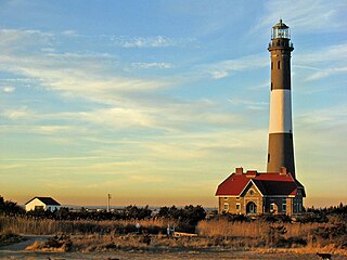
The Fire Island Lighthouse is a visible landmark on the Great South Bay, in southern Suffolk County, New York on the western end of Fire Island, a barrier island off the southern coast of Long Island. The lighthouse is located within Fire Island National Seashore and just to the east of Robert Moses State Park. It is part of the Fire Island Light Station which contains the light, keepers quarters, the lens building containing the original first-order Fresnel lens, and a boat house.
A boundary commission is a legal entity that determines borders of nations, states, constituencies.

Kendrick Peak or Kendrick Mountain is one of the highest peaks in the San Francisco volcanic field north of the city of Flagstaff in the U.S. state of Arizona and is located on the Coconino Plateau in Coconino County.
Clove Mountain is located in Union Vale, Dutchess County, New York, rising to an elevation of 1,398 ft (426 m). It is the town's highest point. It marks the southern extent of the Taconic Mountains and its bedrock is metamorphic, composed of rocks like schist, phyllite, and metagraywacke. Flora and fauna on the mountain are consistent with those found throughout the broader New England Uplands. Rattlesnakes are commonly found on the mountain.
Area of responsibility (AOR) is a pre-defined geographic region assigned to Combatant commanders of the Unified Command Plan (UCP), that are used to define an area with specific geographic boundaries where they have the authority to plan and conduct operations; for which a force, or component commander bears a certain responsibility. The term may also be used in other countries worldwide but it originated within the United States Armed Forces. This system is designed to allow a single commander to exercise command and control of all military forces in the AOR, regardless of their branch of service.
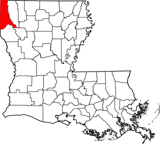
This is a list of the National Register of Historic Places listings in Caddo Parish, Louisiana.
Great Lakes Treaty may refer to: