Boundary Fire (2017)

Last updated

Boundary Fire
Boundary Fire 2017 (34583638403).jpg
Firefighter watching the Boundary Fire, June 17, 2017
Location Coconino and Kaibab National Forests, Arizona, United States
Coordinates 35°25′55″N111°49′52″W / 35.432°N 111.831°W / 35.432; -111.831
Statistics
Cost$9.4 million (equivalent to $11.1 million in 2022)
Date(s)June 1 – July 3, 2017
Burned area17,788 acres (71.99  km2; 27.794  sq mi)
CauseLightning
Map
Boundary Fire (2017).png
The total footprint of the Boundary Fire, from the National Interagency Fire Center
USA Arizona location map.svg
FireIcon.svg
The location of the Boundary Fire, in northern Arizona

The Boundary Fire was a 2017 wildfire in Arizona that burned 17,788 acres (7,199 ha) of the Coconino and Kaibab National Forests. The fire was ignited on June 1 when lightning struck a spot on the northeast side of Kendrick Peak within the Coconino National Forest. The fire spread rapidly because of high temperatures, steep terrain, leftovers from a wildfire in 2000, and high wind speeds.

Contents

The winds blew smoke over local communities and infrastructure, leading to the closure of U.S. Route 180 from June 8 to June 21. Smoke was also visible from the Grand Canyon. The Boundary Fire burned out on July 3, 2017, after 32 days of firefighting. The cost of managing the fire was $9.4 million (equivalent to $11.1 million in 2022). Damage to the area's foliage increased the risk of landslides into 2018.

Background

Wildfires are a natural part of the ecological cycle of the Southwestern United States, [1] :3–6 but human-induced climate change has caused them to increase in number, destructiveness, duration, and frequency. [2] The Boundary Fire was one of 2,321 wildfires that burned 429,564 acres (173,838 ha) in Arizona in 2017. [3] In a report released in April 2017, about a month before the fire, Arizona State Forester Jeff Whitney expected a typical season in the state's northern forests but one with high fire potential in the state's southern grasslands because of high temperatures, low humidity, and an abundance of fuels. [4] Temperatures in Arizona were higher than usual through the 2017 season; [5] :1 on July 4 the National Weather Service stated that that year's June was the fifth-hottest recorded in the city of Flagstaff, which sits between the Coconino and Kaibab National Forests. [6] [7] According to the Arizona Department of Health Services, Flagstaff recorded temperatures of up to 120 °F (49 °C) between June 12 and June 27. [8] By August, wildfires had burned the most land since the 2011 season. [9]

Progression

The Boundary Fire was sparked when lightning struck the northeast slope of Kendrick Peak, within Coconino National Forest, at about 2:02 pm on June 1, 2017. [10] The fire grew to 380 acres (150 ha) by June 6. Owing to the danger posed to firefighters by difficult terrain and leftover dead trees from the Pumpkin Fire in 2000, the United States Forest Service (USFS) decided to confine the Boundary Fire to a 15,000-acre (6,100 ha) area around the mountain and allow it to burn out naturally. Firefighters began creating firebreaks along roads in the area on June 6, especially to the west of the fire. [11] [12] On June 8, high winds fanned the fire over the firebreaks to its north and towards U.S. Route 180 (US 180), 2 mi (3.2 km) from the fire at that time. [13] [14] [15] That night, fire managers closed US 180 as firefighters monitored the fire's spread. [14] [16] [17] Smoke from the Boundary Fire drifted into communities surrounding the fire, such as Flagstaff, and was visible from the Grand Canyon, approximately 65 mi (105 km) north of Flagstaff. [16] [18] [19]

By June 9, the Boundary Fire had grown to 1,550 acres (630 ha) and was burning along US 180 and within both Coconino and Kaibab National Forests. [16] Fanned by strong winds on June 10 and 11, the fire swelled to 4,420 acres (1,790 ha) and was being managed by 261 firefighters. [20] [21] [22] After June 12, reduced winds enabled the USFS to use aerial ignition, a form of controlled burn, to spread the fire uphill more quickly, reducing the damage to the soil from the fire. [23] By June 14, the fire had grown to 5,784 acres (2,341 ha) and was being managed by almost 500 firefighters with aerial firefighting assets. [23] [24] Low wind speeds allowed ground crews and aerial assets to continue with controlled burns from June 15 to June 19, [25] [26] [27] [28] ahead of forecasted high temperatures in the following days. By June 19, the fire had burned 8,067 acres (3,265 ha). [29] The next day brought light rain, cloud cover, and a higher humidity, which caused the fire to burn lower to the ground and consume detritus rather than foliage. Firefighters were able to secure fire breaks and private property, increasing the portion of the fire that was contained from 18% to 30%. [30]

The visibility along US 180 had improved enough by June 21 to allow the Arizona Department of Transportation to reopen the road with reduced speed limits. [31] On June 22, firefighters raised containment of the Boundary Fire to 42 percent despite high winds and temperatures that fanned it to 11,540 acres (4,670 ha). [32] On June 23, the USFS stated that it believed the area closed by the fire could expand to 18,000 acres (7,300 ha), [33] but made progress in containing its spread. [34] [35] By June 25, the fire had grown to 17,049 acres (6,899 ha) but was 88 percent contained, [36] and temperatures dipped to 88 °F (31 °C). [37] Aerial firefighting assets were temporarily grounded on June 25 because a civilian drone flew over the fire. [38] The fire burned out on July 3. [5] :14

Aftermath

The Boundary Fire burned 17,788 acres (7,199 ha) over 32 days and cost $9.4 million (equivalent to $11.1 million in 2022) to suppress. [5] :14 [10] [39] Of the total area burned, three percent suffered total foliage mortality. No structures were damaged or destroyed. Four evacuated civilians suffered injuries related to the fire. [5] :14–15 Almost 500 firefighters worked to contain and suppress the Boundary Fire at its height. [40] Due to the smoke from the Boundary Fire and plans for a later prescribed burn, the USFS decided to quickly suppress the Government Fire when it ignited "a few miles away" in the same season. [41] :10

Environmental consequences

Trails on Kendrick Peak did not reopen until September 14, 2017, because of the potential for landslides caused by heavy rains brought by the North American monsoon. [42] The Kaibab National Forest Supervisor stated that the closure was prolonged to "allow the landscape to stabilize during the immediate post-fire period", particularly with the added monsoon conditions. [43] Forest Road 149, near Kendrick Peak, was closed again in July 2018 because the area was at risk for landslides, as stabilizing foliage growth after the Boundary Fire had been slow in that area. [44]

The base camp for fighting the Boundary Fire was located at a nearby fairground. [45] :10 When the National Renewable Energy Laboratory (NREL) visited the site for an audit on June 19, 2017, the camp was consuming 106 US gallons (400 L) of diesel fuel per day for lighting, electricity, and food preservation, as well as 2,250 US gallons (8,500 L) of water. [45] :10–12 The audit also found that 5% of the waste was recycled and all of the batteries were single-use. [45] :12

Related Research Articles

<span class="mw-page-title-main">Mogollon Rim</span> Escarpment of the Colorado Plateau in Arizona, US

The Mogollon Rim is a topographical and geological feature cutting across the northern half of the U.S. state of Arizona. It extends approximately 200 miles (320 km), starting in northern Yavapai County and running eastward, ending near the border with New Mexico. It forms the southern edge of the Colorado Plateau in Arizona.

<span class="mw-page-title-main">Coconino National Forest</span> United States protected area in Arizona

The Coconino National Forest is a 1.856-million acre United States National Forest located in northern Arizona in the vicinity of Flagstaff, with elevations ranging from 2,600 feet to the highest point in Arizona at 12,633 feet. Originally established in 1898 as the "San Francisco Mountains National Forest Reserve", the area was designated a U.S. National Forest by Pres. Theodore Roosevelt on July 2, 1908, when the San Francisco Mountains National Forest Reserve was merged with lands from other surrounding forest reserves to create the Coconino National Forest. Today, the Coconino National Forest contains diverse landscapes, including deserts, ponderosa pine forests, flatlands, mesas, alpine tundra, and ancient volcanic peaks. The forest surrounds the towns of Sedona and Flagstaff and borders four other national forests; the Kaibab National Forest to the west and northwest, the Prescott National Forest to the southwest, the Tonto National Forest to the south, and the Apache-Sitgreaves National Forest to the southeast. The forest contains all or parts of nine designated wilderness areas, including the Kachina Peaks Wilderness, which includes the summit of the San Francisco Peaks. The headquarters are in Flagstaff. The Coconino National Forest consists of three districts: Flagstaff Ranger District, Mogollon Rim Ranger District, and Red Rock Ranger District, which have local ranger district offices in Flagstaff, Happy Jack, and Sedona.

<span class="mw-page-title-main">Kendrick Peak</span> Mountain in Arizona

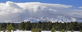
Kendrick Peak or Kendrick Mountain is one of the highest peaks in the San Francisco volcanic field north of the city of Flagstaff in the U.S. State of Arizona and is located on the Coconino Plateau in Coconino County.

<span class="mw-page-title-main">Kendrick Mountain Wilderness</span> Protected area in Coconino County, Arizona

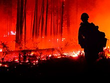
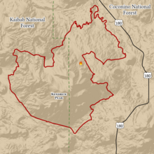
Kendrick Mountain Wilderness is a 6,510-acre (26.3 km2) wilderness area in the U.S. State of Arizona. It lies north of the city of Flagstaff on the Coconino Plateau in Coconino County. Kendrick Mountain Wilderness was designated a protected Wilderness area by Congress in 1984. About two thirds of the wilderness is contained within the Kaibab National Forest. Kendrick Mountain Wilderness contains 10,418-foot (3,175 m) Kendrick Peak, upon which a fire lookout has been located since the early 1900s.

<span class="mw-page-title-main">Oak Creek Canyon</span> River gorge located in northern Arizona between the cities of Flagstaff and Sedona

Oak Creek Canyon is a river gorge located in northern Arizona between the cities of Flagstaff and Sedona. The canyon is often described as a smaller cousin of the Grand Canyon because of its scenic beauty. State Route 89A enters the canyon on its north end via a series of hairpin turns before traversing the bottom of the canyon for about 13 miles (21 km) until the highway enters the town of Sedona.

<span class="mw-page-title-main">Schultz Fire</span> 2010 wildfire in Arizona

The Schultz Fire was a wildfire which burned over 15,000 acres (6,100 ha), including Schultz Peak in Coconino National Forest near Flagstaff, Arizona, in June 2010. The suspected cause is a campfire left unattended, and the United States Forest Service is offering a $2500 reward for information.

<span class="mw-page-title-main">2012 Colorado wildfires</span>

The 2012 Colorado wildfires were an unusually devastating series of Colorado wildfires, including several separate fires that occurred throughout June, July, and August 2012. At least 34,500 residents were evacuated in June.

<span class="mw-page-title-main">King Fire</span> 2014 wildfire in El Dorado County, California

The 2014 King Fire was a large wildfire in El Dorado County, California, which burned 97,717 acres primarily in the Eldorado National Forest. The wildfire started on September 13, 2014, near Pollock Pines, California, to the east of Sacramento. The ensuing fire suppression effort, which cost more than $100 million and engaged more than 8,000 personnel at its peak, allowed for the full containment of the King Fire by October 9, 2014. Despite the size and ferocity of the fire, it caused no deaths. Eighty structures were destroyed, the majority of them outbuildings. The King Fire was determined to have been caused by an act of arson and a suspect was swiftly apprehended and convicted in 2016.

<span class="mw-page-title-main">Tinder Fire</span> 2018 wildfire in Arizona, United States

The Tinder Fire was a wildfire that burned 16,309 acres (6,600 ha) of the Coconino National Forest in the U.S. state of Arizona during April and May 2018. The fire was detected by a United States Forest Service (USFS) lookout tower on April 27, 2018, and firefighters began working to contain its spread within the day. Benefiting from strong winds, low humidity, and high temperatures, the fire grew rapidly over late April, prompting the closure of Arizona State Route 87 and evacuation orders for 1,000 houses in Coconino County. These orders remained until May 4. Almost 700 firefighters were involved in combating the fire, which was fully contained on May 24. The investigation into the fire determined that the Tinder Fire was caused by a prohibited campfire.

<span class="mw-page-title-main">Rattlesnake Fire (2018)</span> 2018 wildfire in Arizona, United States

The Rattlesnake Fire was a wildfire that burned 26,072 acres (10,551 ha) in Navajo and Greenlee Counties, in Arizona. The fire was detected on April 11, 2018, on the Fort Apache Indian Reservation and spread onto the San Carlos Indian Reservation and Apache-Sitgreaves National Forests over the following four days. Fanned by high winds, the Rattlesnake Fire spread rapidly until it was contained on May 1. The fire continued to burn within containment until May 27. No structures were damaged or destroyed by the fire, but 15 firefighters were injured. Investigators suspected the cause of the fire was human activity, but it was never determined with certainty.

<span class="mw-page-title-main">El Dorado Fire</span> 2020 wildfire in San Bernardino County, California

The El Dorado Fire was a wildfire that burned 22,744 acres in San Bernardino and Riverside counties of California from September to November 2020. It was ignited on September 5 by a pyrotechnic device at a gender reveal party in El Dorado Ranch Park; it quickly spread to the San Gorgonio Wilderness Area of the San Bernardino National Forest. Burning over a 71-day period, the fire destroyed 20 structures and resulted in one firefighter fatality, for which the couple hosting the party were charged with involuntary manslaughter.

<span class="mw-page-title-main">Goodwin Fire</span> 2017 wildfire in Arizona, United States

The Goodwin Fire was a wildfire that burned 28,516 acres (11,540 ha) in the U.S. state of Arizona over 16 days, from June 24 to July 10, 2017. The fire destroyed 17 homes and damaged another 19 structures, but no firefighters or civilians were injured or died in the fire. Investigators did not determine any particular cause for the fire.

<span class="mw-page-title-main">2021 Arizona wildfires</span> Wildfires in Arizona during spring and summer 2021

The 2021 Arizona wildfire season was a series of wildfires that burned across the state of Arizona, United States. Wildfires across the state burned 524,428 acres (212,228 ha) of land in at least 1,773 fires throughout the state, fueled in part by a drought, hot temperatures, and thunderstorms producing dry lightning. At one point in late June, over 20 active wildfires were burning across the state.

<span class="mw-page-title-main">Sawmill Fire (2017)</span> 2017 wildfire in Arizona, United States

The Sawmill Fire was a wildfire that burned 46,991 acres (190 km2) in the U.S. state of Arizona in April 2017. The fire was caused by the detonation of a target packed with Tannerite at a gender reveal party in the Coronado National Forest. No injuries or fatalities resulted from the fire, nor were any buildings destroyed, though the fire did come close to the historic Empire Ranch, a National Register of Historic Places property. Over 800 personnel from various federal, state, and local agencies and organizations worked to contain and then extinguish the Sawmill Fire at a cost of $8.2 million.

<span class="mw-page-title-main">Tunnel Fire (2022)</span> 2022 Arizona wildfire

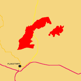
The Tunnel Fire was a wildfire burning in Coconino National Forest and Sunset Crater Volcano National Monument, the Lack Bill Park neighborhood north of the city of Flagstaff, Arizona in the United States, and along U.S. Route 89. The fire was named after a tunnel landmark on Waterline Road, near where it ignited on Sunday, April 17, 2022. On June 3, 2022, the wildfire was declared 100% contained by AZIEN. It had burned 26,532 acres and had destroyed 30 homes. No fatalities or injuries were reported.

<span class="mw-page-title-main">June 2022 Flagstaff wildfires</span> Flagstaff wildfires

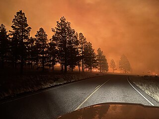
The June 2022 Flagstaff wildfires was a series of wildfires burning near the city of Flagstaff, Arizona. At least three wildfires were reported near Flagstaff and caused hundreds of people to evacuate. However, two of the three reported fires, which are the Haywire and Double fires, combined on June 13. Before the merger of both of the fires, the Double Fire burned 500 acres (200 ha). The first wildfire to be discovered was the Pipeline Fire on June 12 at around 10:15 AM (MST); By Monday evening on June 13, the fire burned 5,000 acres (2,000 ha). As of June 13, 2022, no injuries or deaths have been reported, and one structure has been destroyed.

<span class="mw-page-title-main">Frye Fire</span> 2017 wildfire in Arizona, United States

The Frye Fire was a wildfire that burned 48,443 acres (19,604 ha) in Graham County, Arizona, United States, from June 7 to September 1, 2017. The fire was ignited by a lightning strike on Mount Graham, within the Coronado National Forest, and spread rapidly until it was mostly contained on July 12. The Frye Fire destroyed three buildings, briefly threatened the Mount Graham International Observatory, cost $26 million to contain and suppress, and involved more than 800 firefighters. There were no fatalities, but 63 firefighters were quarantined as a result of a strep throat outbreak.

<span class="mw-page-title-main">Snake Ridge Fire</span> 2017 wildfire in Arizona, United States

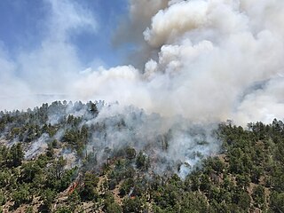
The Snake Ridge Fire was a wildfire that burned 15,333 acres (62.05 km2) of the Coconino National Forest in the U.S. State of Arizona. The fire was ignited by a lightning strike on May 19, 2017, as the United States Forest Service (USFS) was conducting controlled burns within the Coconino National Forest to reduce the severity of future wildfires in the area. The USFS decided to manage the Snake Ridge Fire, named after the feature where the fire was ignited, as a controlled burn. Firefighting efforts focused on protecting infrastructure by burning fuels near power lines. These burns were completed on June 4 and the USFS subsequently allowed the fire, which had by this time been surrounded by firebreaks, to burn out. The fire was allowed to burn until July 13 and cost a total of $1 million to manage and contain. There were no serious environmental consequences as a result of the fire.

References

  1. Pyne, Stephen J. (2016). The Southwest: A Fire Survey. University of Arizona Press. ISBN   978-0-8165-3448-7.
  2. "Focus on Western Wildfires". Fifth National Climate Assessment. National Climate Assessment. Archived from the original on December 22, 2023. Retrieved February 8, 2024.
  3. "National Report of Wildland Fires and Acres Burned by State" (PDF). National Interagency Fire Center. 2017. Archived from the original (PDF) on June 28, 2018. Retrieved January 25, 2023.
  4. Jeong, Yihyun (April 11, 2017). "What to expect for Arizona's 2017 wildfire season". The Arizona Republic . Archived from the original on January 28, 2024. Retrieved January 25, 2023.
  5. 1 2 3 4 Lynch, Michael; Evans, Alexander (May 2018). "2017 Wildfire Season: An Overview" (PDF). Southwestern United States. Northern Arizona University. Archived (PDF) from the original on May 12, 2021. Retrieved December 30, 2022.
  6. Vanek, Corina; Adams-Ockrassa, Suzanne (July 4, 2017). "June was fifth-hottest, monsoon to begin this week" . Arizona Daily Star . Archived from the original on July 4, 2017. Retrieved January 9, 2024.
  7. "Flagstaff Ranger District". Coconino National Forest . United States Forest Service . Retrieved February 25, 2024.
  8. Christ, Cara (April 13, 2018). "Stakeholders Gather for Arizona Extreme Heat Planning Workshop". Arizona Department of Health Services. Archived from the original on May 26, 2021. Retrieved January 9, 2024.
  9. Ziegler, Zachary (August 31, 2017). "Looking back on fire season in Arizona, and places touched by the flames". Arizona Public Media . Archived from the original on November 8, 2017. Retrieved January 9, 2023.
  10. 1 2 "Boundary Fire". InciWeb . United States Forest Service. Archived from the original on September 8, 2018. Retrieved June 15, 2023.
  11. "Type III Incident Management Team takes command of wildfire located on Kendrick Mountain northwest of Flagstaff". Coconino National Forest . United States Forest Service. June 6, 2017. Archived from the original on June 15, 2023. Retrieved June 15, 2023.
  12. Cowan, Emery (June 6, 2017). "9:30 a.m. update: Type III team assigned to Kendrick Mountain fire" . Arizona Daily Sun . Archived from the original on June 8, 2023. Retrieved June 15, 2023.
  13. "Boundary Fire (Kendrick Mountain): Increased Winds Cause Significant Growth on Boundary Fire; Highway 180 to Close Temporarily Due to Potential Smoke Impacts". Coconino National Forest . United States Forest Service. June 8, 2017. Archived from the original on June 16, 2023. Retrieved June 16, 2023.
  14. 1 2 "3:45 p.m. Kendrick fire jumps containment lines; Highway 180 to be closed for smoke" . Arizona Daily Sun . June 8, 2017. Archived from the original on June 16, 2023. Retrieved June 16, 2023.
  15. "8 a.m. update: Kendrick fire jumps northern containment line, Highway 180 remains closed". Williams–Grand Canyon News. June 8, 2017. Archived from the original on June 17, 2023. Retrieved June 17, 2023.
  16. 1 2 3 Cowan, Emery (June 9, 2017). "Kendrick Mountain fire triples in size, Highway 180 to remain closed" . Arizona Daily Sun . Archived from the original on June 17, 2023. Retrieved June 17, 2023.
  17. "U.S. Highway 180 to Grand Canyon closes as Boundary Fire spreads". Arizona Public Media . Associated Press. June 9, 2017. Archived from the original on June 22, 2023. Retrieved June 22, 2023.
  18. McKenney, Loretta (July 11, 2017). "Northern Arizona air quality in question after smoky wildfire season". Navajo-Hopi Observer . Archived from the original on June 17, 2023. Retrieved June 17, 2023.
  19. "Doney Park meeting tonight to discuss Kendrick fire, smoke" . Arizona Daily Sun . June 15, 2017. Archived from the original on July 4, 2023. Retrieved July 4, 2023.
  20. Cowan, Emery (June 10, 2017). "Saturday afternoon update: Type 2 team takes over Kendrick Mountain fire, grows to 3,800 acres" . Arizona Daily Sun . Archived from the original on June 17, 2023. Retrieved June 17, 2023.
  21. "Boundary Fire (Kendrick Mountain): Type II Incident Management Team Takes Command of the Boundary Fire". Coconino National Forest . United States Forest Service. June 10, 2017. Archived from the original on June 17, 2023. Retrieved June 17, 2023.
  22. "Boundary Fire (Kendrick Mountain): Wind-Driven Fire Growth on the Boundary Fire". Coconino National Forest . United States Forest Service. June 11, 2017. Archived from the original on June 18, 2023. Retrieved June 22, 2023.
  23. 1 2 "Boundary Fire (Kendrick Mountain): Aerial Ignition Operations Begin on Kendrick Mountain". Coconino National Forest . United States Forest Service. June 14, 2017. Archived from the original on June 22, 2023. Retrieved June 22, 2023.
  24. Cowan, Emery (June 14, 2017). "3 p.m. Wednesday update: Boundary fire smoke drifting toward Flagstaff" . Arizona Daily Sun . Archived from the original on June 22, 2023. Retrieved June 22, 2023.
  25. "Boundary Fire (Kendrick Mountain): Calm winds allow continued air operations". Coconino National Forest . United States Forest Service. June 15, 2017. Archived from the original on January 9, 2024. Retrieved January 9, 2024.
  26. "Boundary Fire (Kendrick Mountain): Increased Smoke Production Expected While Crews Make Progress on the Boundary Fire". Coconino National Forest . United States Forest Service. June 16, 2017. Archived from the original on January 9, 2024. Retrieved January 9, 2024.
  27. "Boundary Fire (Kendrick Mountain): Timing is everything". Coconino National Forest . United States Forest Service. June 17, 2017. Archived from the original on January 9, 2024. Retrieved January 9, 2024.
  28. "Boundary Fire (Kendrick Mountain): More Smoke in the Air". Coconino National Forest . United States Forest Service. June 18, 2017. Archived from the original on January 9, 2024. Retrieved January 9, 2024.
  29. "Boundary Fire (Kendrick Mountain): Increased Smoke Production Expected While Crews Make Progress on the Boundary Fire". Coconino National Forest . United States Forest Service. June 19, 2017. Archived from the original on January 9, 2024. Retrieved January 9, 2024.
  30. "Boundary Fire (Kendrick Mountain): Firefighters Make a Big Stride in Boundary Fire Containment". Coconino National Forest . United States Forest Service. June 20, 2017. Archived from the original on January 9, 2024. Retrieved January 9, 2024.
  31. "US 180 reopens after smoke conditions improve" . Arizona Daily Sun . June 21, 2017. Archived from the original on January 9, 2024. Retrieved January 9, 2024.
  32. "Boundary Fire (Kendrick Mountain): Suppression Repair Needs Assessed". Coconino National Forest . United States Forest Service. June 22, 2017. Archived from the original on January 9, 2024. Retrieved January 9, 2024.
  33. "Boundary Fire update". Coconino National Forest . United States Forest Service. June 23, 2017. Archived from the original on January 9, 2024. Retrieved January 9, 2024.
  34. "Boundary Fire (Kendrick Mountain): Containment increases, Flagstaff gets a break from heavy smoke". Coconino National Forest . United States Forest Service. June 24, 2017. Archived from the original on January 9, 2024. Retrieved January 9, 2024.
  35. "Unhealthy air for sensitive groups on tap Saturday in Flagstaff region" . Arizona Daily Sun . June 24, 2017. Archived from the original on January 9, 2024. Retrieved January 9, 2024.
  36. "Boundary Fire update". Coconino National Forest . United States Forest Service. June 25, 2017. Archived from the original on January 9, 2024. Retrieved January 9, 2024.
  37. Vanek, Corina (June 25, 2017). "Streak of 90-degree days in Flagstaff snapped" . Arizona Daily Sun . Archived from the original on January 9, 2024. Retrieved January 9, 2024.
  38. Marsh, Adrian (June 25, 2017). "Drones continue to cause problems for wildfire crews". The Arizona Republic . Archived from the original on January 9, 2024. Retrieved January 9, 2024.
  39. Johnston, Louis; Williamson, Samuel H. (2023). "What Was the U.S. GDP Then?". MeasuringWorth. Retrieved November 30, 2023. United States Gross Domestic Product deflator figures follow the Measuring Worth series.
  40. Cowen, Emery (July 16, 2017). "What's behind the Kendrick Mountain fire's $9.4 million price tag?" . Arizona Daily Sun . Archived from the original on January 9, 2024. Retrieved January 9, 2024.
  41. Timberlake, Thomas J.; Schultz, Courtney A.; Evans, Alexander; Abrams, Jesse B. (2020). "Working on institutions while planning for forest resilience: a case study of public land management in the United States". Journal of Environmental Planning and Management: 1–21. doi:10.1080/09640568.2020.1817730.
  42. "Kendrick Mountain trails reopened" . Arizona Daily Sun . September 15, 2017. Archived from the original on January 9, 2024. Retrieved January 9, 2024.
  43. "Forest Service reopens Kendrick Mountain". Williams–Grand Canyon News. September 19, 2017. Retrieved January 30, 2024.
  44. "Forest Road 149 closed due to risk of flooding". Arizona Daily Sun . July 18, 2018. Archived from the original on January 28, 2024. Retrieved January 9, 2024 via Newspapers.com.
  45. 1 2 3 Kandt, Alicen; Elgqvist, Emma; Salasovich, Jimmy (2019). Opportunities for Energy, Water, and Waste Reduction at U.S. Forest Service Fire Camps (PDF) (Report). Golden, CO: National Renewable Energy Laboratory.