
Bellingham is the county seat of Whatcom County in the U.S. state of Washington. It lies 21 miles (34 km) south of the U.S.–Canada border, between Vancouver, British Columbia, 52 miles (84 km) to the northwest and Seattle 90 miles (140 km) to the south.

A gold rush or gold fever is a discovery of gold—sometimes accompanied by other precious metals and rare-earth minerals—that brings an onrush of miners seeking their fortune. Major gold rushes took place in the 19th century in Australia, Greece, New Zealand, Brazil, Chile, South Africa, the United States, and Canada while smaller gold rushes took place elsewhere.

The General Mining Act of 1872 is a United States federal law that authorizes and governs prospecting and mining for economic minerals, such as gold, platinum, and silver, on federal public lands. This law, approved on May 10, 1872, codified the informal system of acquiring and protecting mining claims on public land, formed by prospectors in California and Nevada from the late 1840s through the 1860s, such as during the California Gold Rush. All citizens of the United States of America 18 years or older have the right under the 1872 mining law to locate a lode or placer (gravel) mining claim on federal lands open to mineral entry. These claims may be located once a discovery of a locatable mineral is made. Locatable minerals include but are not limited to platinum, gold, silver, copper, lead, zinc, uranium and tungsten.
In geology, a lode is a deposit of metalliferous ore that fills or is embedded in a fracture in a rock formation or a vein of ore that is deposited or embedded between layers of rock. The current meaning dates from the 17th century, being an expansion of an earlier sense of a "channel, watercourse" in Late Middle English, which in turn is from the 11th-century meaning of lode as a "course, way".

The Comstock Lode is a lode of silver ore located under the eastern slope of Mount Davidson, a peak in the Virginia Range in Virginia City, Nevada, which was the first major discovery of silver ore in the United States and named after American miner Henry Comstock.

Nooksack Falls is a waterfall along the North Fork of the Nooksack River in Whatcom County, Washington. The water flows through a narrow valley and drops freely 88 feet into a deep rocky river canyon. The falls are viewable from the forested cover near the cliffs edge. The falls are a short 2/3 of a mile drive off the Mount Baker Highway, Washington. The falls were featured in the hunting scene of the movie The Deer Hunter.

State Route 542 (SR 542) is a 57.24-mile-long (92.12 km) state highway in the U.S. state of Washington, serving Mount Baker in Whatcom County. SR 542 travels east as the Mount Baker Highway from an interchange with Interstate 5 (I-5) in Bellingham through the Nooksack River valley to the Mt. Baker Ski Area at Austin Pass. It serves as the main highway to Mount Baker and the communities of Deming, Kendall, and Maple Falls along the Nooksack River. The highway was constructed in 1893 by Whatcom County as a wagon road between Bellingham and Maple Falls and was added to the state highway system as a branch of State Road 1 in 1925. The branch was transferred to Primary State Highway 1 (PSH 1) during its creation in 1937 and became SR 542 during the 1964 highway renumbering.

Mount Baker Wilderness is a 119,989-acre (48,558 ha) wilderness area within the Mount Baker-Snoqualmie National Forest in the western Cascade Range of northern Washington state. Its eastern border is shared with the boundary of the Stephen Mather Wilderness and North Cascades National Park for a distance of 40 miles. The wilderness extends from State Route 20 north to the Canada–US border. On the west, it is bounded by the foothills of the Puget Sound lowlands.

The historical Winchester Lookout, located in the North Cascades in the U.S. state of Washington, provides views of the Northern Picket Range, Mount Baker, Mount Shuksan, Mount Larrabee, and Canadian peaks. The steep snowfields usually require an ice-axe well into July. The Twin Lakes road may not be passable to the trailhead which will add 2 miles (3.2 km) to the hike. Volunteers from the Mount Baker Club maintain the lookout with 2 work parties per year.

In the United States, gold mining has taken place continually since the discovery of gold at the Reed farm in North Carolina in 1799. The first documented occurrence of gold was in Virginia in 1782. Some minor gold production took place in North Carolina as early as 1793, but created no excitement. The discovery on the Reed farm in 1799 which was identified as gold in 1802 and subsequently mined marked the first commercial production.
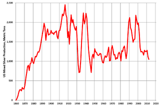
Silver mining in the United States began on a major scale with the discovery of the Comstock Lode in Nevada in 1858. The industry suffered greatly from the demonetization of silver in 1873 by the Coinage Act of 1873, known pejoratively as the "Crime of 73", but silver mining continues today.
Gold mining in Colorado, a state of the United States, has been an industry since 1858. It also played a key role in the establishment of the state of Colorado.
The Sweetwater Mountains are a small mountain range in northern Mono County, California and western Lyon County, Nevada, separating the West Walker River from the East Walker River. Most of the range is only accessible by four wheel drive vehicle, on foot, or pack animal. Most of the range is contained in the Toiyabe National Forest. The place name appears on the 1874 California Geologic Survey map of California and Nevada.
Poeville, also known as Peavine until 1863, is the site of a historical mining town, established in 1864. John Poe, a professional promoter from Michigan allegedly related to Edgar Allan Poe, discovered rich gold and silver veins in 1862 on the slopes of Peavine Mountain. After the discovery of ore, Poe announced that the veins comprised the next Comstock Lode; he presented extracted ore at the state fair of 1864 as rich in content. As a result, the former mining camp, called Poe City (Poeville) or Podunk (Poedunk), grew to 200 people by 1864. Ore production in the mining district and population peaked around 1873-1874 with several hundred people living in town, supported by three hotels and a post office. The post office, named "Poeville", operated between September 1, 1874, and March 24, 1878. As of 2010 the population of the community is 0.
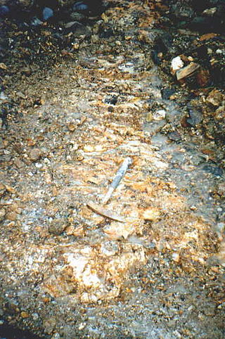
The Mount Baker gold rush occurred in Whatcom County, Washington, United States, upon the discovery of the Lone Jack Mine. The Mount Baker area was flooded with prospectors which led to the staking of many claims both patented and unpatented. The most notable mines staked soon after the Lone Jack are the Boundary Red Mountain Mine, Garget Mine, Gold Basin Mine, Silver Tip Mine, and the Evergreen Mine.
Rimini, is a ghost town in Lewis and Clark County, Montana, United States. It is one of the oldest mining districts in the state. It was established when silver lodes were discovered in 1864. Other names for the district were Lewis and Clark, Tenmile, Vaughn, Colorado, and Bear Gulch. It was the site of Camp Rimini.

The Ortiz Mountains are a mountain range in northern New Mexico, United States, in Santa Fe County, northeast of the Sandia Mountains and due north of the San Pedro Mountains. The Ortiz include Placer Peak, the highest peak in the range at 8,858 feet, Lone Mountain at 7,310 feet, Cedar Mountain at 7,041 feet, Cerro Chato at 6,965 feet, and the foothills known as the Los Lomas de la Bolsa.

The Juneau gold belt is located in the southeastern portion of the U.S. state of Alaska. This belt is approximately 100 miles (160 km) in length, north/northwest-trending, and extends from Berners Bay southeastward to Windham Bay, 60 miles (97 km) southeast of Juneau, and includes Douglas Island. The belt contains over 200 gold-quartz-vein deposits with production nearing 7,000,000 ounces (200,000,000 g) of gold. More than three-quarters of Alaska's lode gold was mined from the Juneau gold belt.
McNulty rhyolite is one of four intrusive, igneous geological formations, the Chalk Mountain nevadite, Lincoln porphyry, McNulty rhyolite and Quail porphyry, described, mapped, and named by S. F. Emmons in 1898 within the Tenmile Mining District of southern Summit County, Colorado. The McNulty rhyolite, which is also known as the McNulty Gulch rhyolite, is described by S. F. Emmons as a fine-grained porphyritic rhyolite that is light gray in color and contains many small white feldspars and locally some small smoky quartz crystals. He mapped it as being exposed as small irregular masses in McNulty Gulch and southward beyond the area of the Tenmile Mining District that was mapped at the time. One exposure above the Railroad Boy tunnel, his location 45 in McNulty Gulch, exhibited small drusy cavities containing little tablets of tridymite. He proposed that this rhyolite was either intruded contemporaneously withy or later than the Chalk Mountain nevadite at the time of eruption. Based on field mapping, the McNulty rhyolite was interpreted to cross-cut and post-date the Lincoln and the Quail porphyries. Later geologic mapping in the Tenmile Mining District eliminated the McNulty rhyolite as a recognized geologic formation.

Highland Park, also known as Highland Pines, is a populated place situated near Prescott and within the Prescott National Forest, in Yavapai County, Arizona, United States. Highland Pines is the promotional name associated with the Highland Park areas several subdivisions. In the Arizona Territorial era up to 1912, and Statehood until around the late 1920s, this particular area of land acted as a cattle ranch with a mining history, lies within the Thumb Butte Mining District, which appears to be initially platted by the Arizona Corporation Highland Pine Properties Inc. beginning in the late 1950s.
