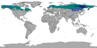
The subarctic climate is a continental climate with long, cold winters, and short, warm to cool summers. It is found on large landmasses, often away from the moderating effects of an ocean, generally at latitudes from 50°N to 70°N, poleward of the humid continental climates. Like other Class D climates, they are rare in the Southern Hemisphere, only found at some isolated highland elevations. Subarctic or boreal climates are the source regions for the cold air that affects temperate latitudes to the south in winter. These climates represent Köppen climate classification Dfc, Dwc, Dsc, Dfd, Dwd and Dsd.

Alamosa is the Home Rule City that is the county seat of Alamosa County, Colorado, United States. Alamosa is located along the Rio Grande. The city population was 9,806 in the 2020 United States Census. The city is the commercial center of the San Luis Valley in south-central Colorado, and is the home of Adams State University.

Spearfish is a city in Lawrence County, South Dakota, United States. The population was 12,193 at the time of the 2020 census, making it the 10th most populous city in South Dakota. Spearfish is the largest city in Lawrence County and the home of Black Hills State University.
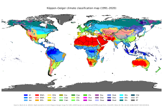
The Köppen climate classification divides Earth climates into five main climate groups, with each group being divided based on patterns of seasonal precipitation and temperature. The five main groups are A (tropical), B (arid), C (temperate), D (continental), and E (polar). Each group and subgroup is represented by a letter. All climates are assigned a main group. All climates except for those in the E group are assigned a seasonal precipitation subgroup. For example, Af indicates a tropical rainforest climate. The system assigns a temperature subgroup for all groups other than those in the A group, indicated by the third letter for climates in B, C, D, and the second letter for climates in E. For example, Cfb indicates an oceanic climate with warm summers as indicated by the ending b. Climates are classified based on specific criteria unique to each climate type.
The climate of Mumbai is tropical, with defined wet and dry seasons. The mean annual temperature is 27.7 °C or 81.9 °F. Average annual rainfall is 2,213.4 millimetres or 87 inches in Colaba, which represents South Mumbai and 2,502.3 millimetres or 99 inches in Santacruz, which represents central and suburban Mumbai. The mean maximum average temperatures is about 32 °C (90 °F) in summer and 30 °C (86 °F) in winter, while the average minimums are 26 °C (79 °F) in summer and 18 °C (64 °F) in winter. The city experiences a lengthy, practically rainless dry season, and a relatively short, but extremely rainy wet season; due to the Southwest Monsoon and orographic influences from the nearby Western Ghats.These conditions effectively place Mumbai between a Tropical monsoon climate (Am) and a Tropical savannah climate (Aw), with more tilt towards the former considering annual precipitation.
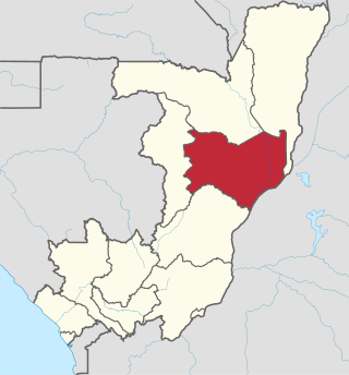
Cuvette is a department of the Republic of the Congo in the central part of the country. It borders the departments of Cuvette-Ouest, Likouala, Plateaux, and Sangha, and internationally, the Democratic Republic of the Congo. The capital is Owando. Cities and towns include Boundji, Makoua and Okoyo.

Pointe-Noire is the second largest city in the Republic of the Congo, following the capital of Brazzaville, and an autonomous department and a commune since the 2002 Constitution. Before this date it was the capital of the Kouilou region. It is situated on a headland between Pointe-Noire Bay and the Atlantic Ocean. Pointe-Noire is the main commercial centre of the country and has a population of 1,420,612 inhabitants in 2023.
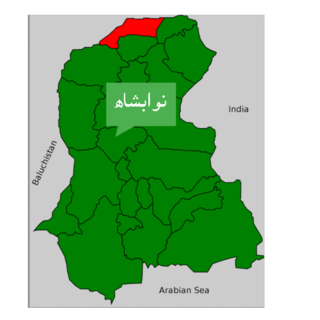
Nawabshah is a tehsil and headquarters of the Shaheed Benazirabad District of Sindh province, Pakistan. This city is situated in the middle of Sindh province. It is the 27th most populous city in Pakistan. Nawabshah Tehsil was established in 1903 by the British government. The tehsil was a part of Hyderabad district. On 1 November 1912, Nawabshah was upgraded to a district status of Sind Division.

Tillabéri is a town in the extreme west of Niger. It is situated 113 kilometres or 70 miles northwest of the capital Niamey on the River Niger. It is an important market town and administrative center, being the capital of department of Tillabéri and Tillabéri Region. The town had a population of 47,678 at the 2012 census.

The climate of Chicago is classified as hot-summer humid continental with hot humid summers and cold, occasionally snowy winters. All four seasons are distinctly represented: Winters are cold and often see snow with below 0 Celsius temperatures and windchills, while summers are warm and humid with temperatures being hotter inland, spring and fall bring bouts of both cool and warm weather and fairly sunny skies. Annual precipitation in Chicago is moderate and relatively evenly distributed, the driest months being January and February and the wettest July and August. Chicago's weather is influenced during all four seasons by the nearby presence of Lake Michigan.

Embarrass is an unincorporated community in Embarrass Township, Saint Louis County, Minnesota, United States.
Milwaukee has a humid continental climate, with four distinct seasons and wide variations in temperature and precipitation in short periods of time. The city's climate is also strongly influenced by nearby Lake Michigan, which creates two varying climates within the Milwaukee area. The urban heat island effect also plays a role in the city's climate, insulating it from winter cold, but keeping it cooler in spring and summer.

The 1936 North American heat wave was one of the most severe heat waves in the modern history of North America. It took place in the middle of the Great Depression and Dust Bowl of the 1930s and caused more than 5,000 deaths. Many state and city record high temperatures set during the 1936 heat wave stood until the 2012 North American heat wave. Many more endure to this day; as of 2022, 13 state record high temperatures were set in 1936. The 1936 heat wave followed one of the coldest winters on record.
Oklahoma City lies in a temperate humid subtropical climate, with frequent variations in weather daily and seasonally, except during the consistently hot and humid summer months. Consistent winds, usually from the south or south-southeast during the summer, help temper the hotter weather. Consistent northerly winds during the winter can intensify cold periods. The normal annual mean temperature is 61.4 °F (16.3 °C); the coolest year was 1895 with a mean of 57.9 °F (14.4 °C), while the warmest 2012 at 64.1 °F (17.8 °C). Precipitation averages 36.52 inches (928 mm) annually, falling on an average 84 days, with the warmer months receiving more; annual precipitation has historically ranged from 15.74 in (400 mm) in 1901 to 56.95 in (1,447 mm) in 2007. The sun shines about 69% of the time, with monthly percent possible sunshine ranging from 60% in December to 80% in July.
Delhi features a monsoon influenced humid subtropical climate bordering a hot semi-arid climate, with high variation between summer and winter temperatures and precipitation. Delhi's version of a humid subtropical climate is markedly different from many other humid subtropical cities such as São Paulo, Houston, and Brisbane in that the city features dust storms and wildfire haze due to its semi-arid climate.
Columbus, Ohio has a humid continental climate, characterized by humid, hot summers and cold winters, with no dry season. The Dfa climate has average temperatures above 22 °C during the warmest months, with at least four months averaging above 10 °C, and below 0 °C during the coldest. The climate is transitional with the Cfa humid subtropical climate to the south, characterized by humid, hot summers and cool winters.
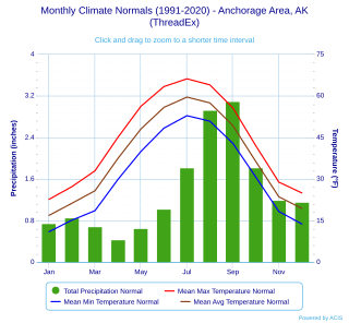
Anchorage, Alaska has a subarctic climate with the code Dsc according to the Köppen climate classification due to its short, cool summers. The weather on any given day is very unpredictable. Some winters feature several feet of snow and cold temperatures, while the summers are typically mild but are cool compared to the contiguous US and interior Alaska. Because of Anchorage's high latitude, summer days are very long and winter daylight hours are very short. The longest day of sunlight being 18hrs and 21 minutes, and shortest being 5 hours and 28 minutes. Anchorage is often cloudy during the winter, which decreases the amount of sunlight experienced by residents.

Boundji is a district of the Cuvette Department in the Republic of the Congo. The administrative seat of the district is Boundji.

A humid subtropical climate is a subtropical-temperate climate type, characterized by long and hot summers, and cool to mild winters. These climates normally lie on the southeast side of all continents, generally between latitudes 25° and 40° and are located poleward from adjacent tropical climates, and equatorward from either humid continental or oceanic climates. It is also known as warm temperate climate in some climate classifications.
Boundji Airport is an airport serving the city of Boundji in Cuvette Department, Republic of the Congo. The runway is on the western edge of the city, and has an additional 700 metres (2,300 ft) of cleared, unpaved overrun on its western end.
