Osnabrück is a district (Landkreis) in the southwest of Lower Saxony, Germany. With 2,122 km2 it is the second largest district of Lower Saxony.
Minden-Lübbecke is a Kreis (district) in the northeastern part of North Rhine-Westphalia, Germany. Neighboring districts are Diepholz, Nienburg, Schaumburg, Lippe, Herford, Osnabrück.

Herford is a Kreis (district) in the northeastern part of North Rhine-Westphalia, Germany. Neighboring districts are Minden-Lübbecke, Lippe, the urban district of Bielefeld and the districts of Gütersloh and Osnabrück.
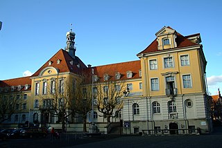
Herford is a town in North Rhine-Westphalia, Germany, located in the lowlands between the hill chains of the Wiehen Hills and the Teutoburg Forest. It is the capital of the district of Herford.
Lippe is a Kreis (district) in the east of North Rhine-Westphalia, Germany. Neighboring districts are Herford, Minden-Lübbecke, Höxter, Paderborn, Gütersloh, and district-free Bielefeld, which forms the region Ostwestfalen-Lippe.

Lage is a town in the Lippe district of North Rhine-Westphalia, Germany, approximatively 8 km northwest of the administrative centre Detmold. It has 35,099 inhabitants (2016). The coat of arms of Lage depicts a farmer's plough. The city is not far from the Teutoburg Forest. Due to its convenient location Lage developed into a traffic hub in the former Principality of Lippe, today's district of Lippe.

Bad Salzuflen is a town and thermal spa resort in the Lippe district of North Rhine-Westphalia, Germany. At the end of 2013, it had 52,121 inhabitants.
Löhne is a town in the district of Herford, in North Rhine-Westphalia, Germany.

The County of Ravensberg was a historical county of the Holy Roman Empire. Its territory was in present-day eastern Westphalia, Germany, at the foot of the Osning or Teutoburg Forest.

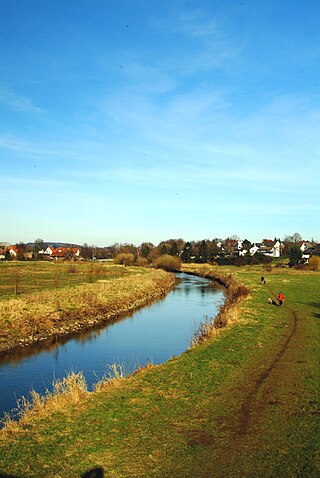
The Werre is a river in the Detmold region (Regierungsbezirk) of North Rhine-Westphalia, Germany, left tributary of the Weser. Its source is near Horn-Bad Meinberg. The total length of the Werre is 71.9 km.

Herford Abbey was the oldest women's religious house in the Duchy of Saxony. It was founded as a house of secular canonesses in 789, initially in Müdehorst by a nobleman called Waltger, who moved it in about 800 onto the lands of his estate Herivurth which stood at the crossing of a number of important roads and fords over the Aa and the Werre. The present city of Herford grew up on this site around the abbey.
Minden-Ravensberg was a Prussian administrative unit consisting of the Principality of Minden and the County of Ravensberg from 1719–1807. The capital was Minden. In 1807 the region became part of the Kingdom of Westphalia, a client state of Napoleonic France. The territory was restored to Prussia after the Napoleonic Wars and became part of the Minden Region within the new Prussian Province of Westphalia in 1815.

Ravensberg Land is a cultural landscape in the district of Ostwestfalen-Lippe in the northeast of the German federal state of North Rhine-Westphalia. It lies between the Wiehen Hills to the north, the Teutoburg Forest to the south, the state border with Lower Saxony to the west and the large bend in the River Weser and the boundary of Lippe district to the east. It thus essentially encompasses the Westphalian part of the Ravensberg Hills. The most important towns are Bielefeld, Herford, Bad Oeynhausen and Bünde.

Kilverbach is a small river on the border of Lower Saxony and North Rhine-Westphalia, Germany. It is 8.4 km long and flows into the Else as a left tributary south of Rödinghausen.
Aa is a river of North Rhine-Westphalia, Germany. It is a left tributary of the Werre, which it joins in Herford. It is formed by the confluence of two small streams in Bielefeld-Milse. In its upper part, it is called Johannisbach.

Butterbach, also known as Putchemühlenbach, is a small river of North Rhine-Westphalia, Germany. It is 4.4 km long and flows into the Werre in Herford.

Düsedieksbach is a small river of North Rhine-Westphalia, Germany. It is 4.8 km long and flows into the Werre near Herford.
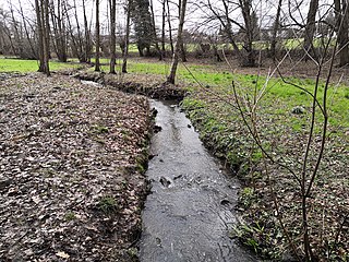
Ellersieker Bach is a river of North Rhine-Westphalia, Germany. It is 2.8 km long and flows into the Werre in Herford.

Steinsieksbach is a small river of North Rhine-Westphalia, Germany. It flows into the Werre near Herford.
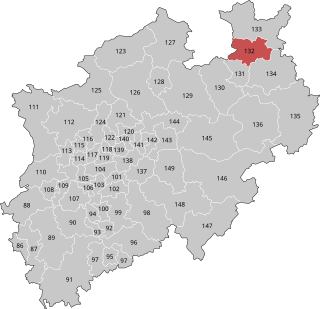
Herford – Minden-Lübbecke II is an electoral constituency represented in the Bundestag. It elects one member via first-past-the-post voting. Under the current constituency numbering system, it is designated as constituency 132. It is located in eastern North Rhine-Westphalia, comprising the Herford district and a small part of the Minden-Lübbecke district.

