Bowling railway station (Lanarkshire and Dunbartonshire Railway)

Last updated

Bowling
Bowling (L&D) Platform.jpeg
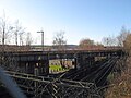
Platform looking east
General information
Location Bowling, West Dunbartonshire
Scotland
Coordinates 55°55′56″N4°29′21″W / 55.9321°N 4.4892°W / 55.9321; -4.4892
Platforms2
Other information
StatusDisused
History
Original company Lanarkshire and Dunbartonshire Railway
Pre-grouping Caledonian Railway
Post-grouping London, Midland and Scottish Railway
Key dates
1 October 1896 [1] Opened
1 January 1917 [1] Closed
1 February 1919 [1] Reopened
5 February 1951 [1] Closed
Structure below platform Bowling-L&D-station.jpg
Structure below platform

Bowling railway station was a railway station located in the village of Bowling, Scotland, on the Lanarkshire and Dunbartonshire Railway.

Contents

Bowling station was closed in 1951 before this section of the L&DR was abandoned in 1960 (the parallel GH&DR being retained and electrified as part of the North Clyde electrification scheme). The trackbed through Bowling now forms a footpath and cycleway, part of National Cycle Network Route 7.

Preceding station Historical railways Following station
Old Kilpatrick
Line and station closed
  Caledonian Railway
Lanarkshire and Dunbartonshire Railway
  Dumbarton East
Station open; line partially open

Related Research Articles

<span class="mw-page-title-main">Livingston South railway station</span> Railway station in West Lothian, Scotland

Livingston South railway station is one of two railway stations serving Livingston in West Lothian, Scotland. It is located on the Shotts Line, 14 miles (23 km) west of Edinburgh Waverley on the way to Glasgow Central. It is managed by ScotRail, who provide all train services.

<span class="mw-page-title-main">Dumbarton Central railway station</span> Railway station in West Dunbartonshire, Scotland

Dumbarton Central railway station serves the town of Dumbarton in West Dunbartonshire, Scotland. This station is on the West Highland Line and the North Clyde Line, 15+34 miles (25.3 km) northwest of Glasgow Queen Street.

<span class="mw-page-title-main">Kirkhill railway station</span> Railway station in South Lanarkshire, Scotland

Kirkhill railway station is a railway station serving the Kirkhill area of the town of Cambuslang, South Lanarkshire, Greater Glasgow, Scotland. The station is managed by ScotRail and is located on the Cathcart Circle Lines. This is the least used station on the Newton Branch.

<span class="mw-page-title-main">Dalreoch railway station</span> Railway station in West Dunbartonshire, Scotland

Dalreoch railway station serves the west end of Dumbarton in West Dunbartonshire, Scotland. The station is managed and served by ScotRail and is served by trains on the North Clyde Line. The station is 16 miles 38 chains (26.5 km) northwest of Glasgow Queen Street, measured via Singer and Maryhill.

<span class="mw-page-title-main">Dumbarton East railway station</span> Railway station in West Dunbartonshire, Scotland

Dumbarton East railway station serves the town of Dumbarton in the West Dunbartonshire region of Scotland. The station is managed by ScotRail and is served by trains on the North Clyde Line, 15 miles (24 km) west of Glasgow Queen Street.

<span class="mw-page-title-main">Bowling railway station</span> Railway station in West Dunbartonshire, Scotland

Bowling railway station serves the village of Bowling in the West Dunbartonshire region of Scotland. This station is on the North Clyde Line, between Kilpatrick and Dumbarton East, 12 miles 70 chains (20.7 km) from Glasgow Queen Street measured via Maryhill. The station is managed by ScotRail who provide all train services.

<span class="mw-page-title-main">Easterhouse railway station</span> Railway station in Glasgow, Scotland

Easterhouse railway station serves the Easterhouse area of Glasgow, Scotland. It was built by the North British Railway as part of their Coatbridge Branch and opened when the branch opened on 1 February 1871. The station is 5¾ miles (9 km) east of Glasgow Queen Street railway station on the North Clyde Line and is managed by ScotRail.

<span class="mw-page-title-main">Airdrie railway station</span> Railway station in North Lanarkshire, Scotland

Airdrie railway station is a railway station serving the town of Airdrie, North Lanarkshire, Scotland. The station is managed by ScotRail and is served by trains on the North Clyde Line, 11 miles (18 km) east of Glasgow Queen Street.

<span class="mw-page-title-main">Clarkston railway station</span> Railway station in East Renfrewshire, Scotland

Clarkston railway station is a suburban side platform railway station in the town of Clarkston, East Renfrewshire, Scotland. The station is managed by ScotRail and is on the East Kilbride branch of the Glasgow South Western Line. It was opened in 1866 by the Busby Railway.

<span class="mw-page-title-main">Partick Central railway station</span> Former railway station in Scotland

Partick Central railway station was a station serving the Partick area of the city of Glasgow. Built in the 1890s by the Lanarkshire and Dunbartonshire Railway Company, it sat on a line that ran along the north bank of the River Clyde from Stobcross to Dumbarton.

<span class="mw-page-title-main">Maryhill Central railway station</span> Former railway station in Scotland

Maryhill Central was a railway station to the north west of Glasgow.

<span class="mw-page-title-main">Kelvinside railway station</span> Former railway station in Scotland

Kelvinside railway station was located on Great Western Road, next to the current Gartnavel General Hospital in the Kelvinside area of Glasgow, Scotland. Part of the Lanarkshire and Dunbartonshire Railway services ran through the station from Glasgow city centre to Maryhill in the north of the city and beyond. The line from the station to Crow Road railway station passes under the current site of Hyndland railway station on the Argyle and North Clyde lines.

<span class="mw-page-title-main">Crow Road railway station</span> Former railway station in Scotland

Crow Road railway station was located in Glasgow, Scotland and served the Broomhill and Hyndland areas of that city.

<span class="mw-page-title-main">Possil railway station</span> Former railway station in Scotland

Possil railway station was situated on Balmore Road, in the north of Glasgow, Scotland and served the Possilpark and Parkhouse areas of the city.

The Bathgate and Coatbridge Railway, also known as the "New Monkland Line", was built by Monkland Railways. It opened on 28 July 1863. The line was absorbed into the Edinburgh and Glasgow Railway on 31 July 1865. The following day, the line became part of the North British Railway.

Cleland and Midcalder Line is a historic railway line in Scotland. Built by the Caledonian Railway and opened in 1869, it provides a link between Glasgow and Edinburgh through the mining communities of Lanarkshire and West Lothian.

<span class="mw-page-title-main">Elvanfoot railway station</span> Former railway station in Scotland

Elvanfoot railway station was a station which served Elvanfoot, in the Scottish county of South Lanarkshire. It was served by local trains on what is now known as the West Coast Main Line.

<span class="mw-page-title-main">Crawford railway station (Scotland)</span> Former railway station in Scotland

Crawford railway station was a station which served the village of Crawford, near Abington, in the Scottish county of South Lanarkshire. It was served by local trains on what is now known as the West Coast Main Line.

<span class="mw-page-title-main">Whiteinch Riverside railway station</span> Former railway station in Scotland

Whiteinch Riverside railway station served the Whiteinch area of the city of Glasgow. It was a two platform station on the Lanarkshire and Dunbartonshire Railway.

<span class="mw-page-title-main">Bridgeton Central railway station</span> Disused railway station in Scotland

Bridgeton Central railway station was located in Glasgow, Scotland and served the Bridgeton area of that city. On the Glasgow City and District Railway it was located on the modern North Clyde line on a branch from High Street and acted as a terminus for services from the north west of the city.

References

Notes

Sources