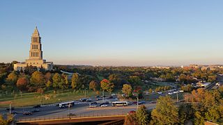
Fairfax County, officially the County of Fairfax is a county of the Commonwealth of Virginia in the United States. Part of Northern Virginia, Fairfax County borders both the City of Alexandria and Arlington County and forms part of the inner suburban ring of Washington, DC. The county is thus predominantly suburban in character, with some urban and rural pockets.
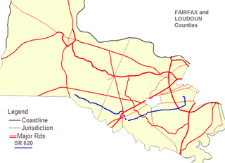
State Route 620 in Fairfax and Loudoun Counties, Virginia is a secondary state highway. The entire length of SR 620 is also known as Braddock Road. SR 620 also has a short concurrency with SR 659 / Union Mill Road in Centreville.

The Fairfax County Public Schools system is a school division in the U.S. commonwealth of Virginia. It is a branch of the Fairfax County government which administers public schools in Fairfax County and the City of Fairfax. FCPS's headquarters is located in the Gatehouse Administration Center in Merrifield, an unincorporated section of the county near the city of Falls Church; the headquarters has a Falls Church address but is not within the city limits.

Fairfax Station is a census-designated place (CDP) in Fairfax County, Virginia, United States. The population was 12,030 at the 2010 census. Fairfax Station is an affluent community in Northern Virginia; its center is located 22 miles (35 km) southwest of Washington, D.C.

State Route 7 (SR 7) is a major primary state highway and busy commuter route in northern Virginia, United States. It travels southeast from downtown Winchester to SR 400 in downtown Alexandria. Its route largely parallels those of the Washington & Old Dominion Trail and the Potomac River. Between its western terminus and I-395, SR 7 is part of the National Highway System.

State Route 236 is a primary state highway in the U.S. state of Virginia. The state highway runs 15.63 miles (25.15 km) from U.S. Route 29 and US 50 in Fairfax east to SR 400 in Alexandria. SR 236 is a major suburban arterial highway that connects the independent cities of Fairfax and Alexandria via Annandale in Fairfax County. The state highway is known as Main Street in City of Fairfax, Little River Turnpike in Fairfax County, where the highway meets Interstate 495 (I-495), and Duke Street in Alexandria, where the road has junctions with I-395 and US 1.
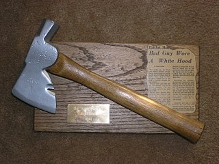
The Bunny Man is an urban legend that originated from two incidents in Fairfax County, Virginia, in 1970, but has been spread throughout the Washington, D.C., area. The legend has many variations; most involve a man wearing a rabbit costume who attacks people with an axe or hatchet.

Colchester is a historic unincorporated community on the Occoquan River in Fairfax County, Virginia.

The earliest electric railway, or streetcar line, in Northern Virginia opened in 1892. At their peak, when merged into a single interurban system, the successors of this and several other lines ran between downtown Washington, D.C., Rosslyn and Arlington Junction – in present-day Crystal City – and out to Mount Vernon, Fairfax City and Nauck. Electric trolleys also went west from Georgetown and Rosslyn on the Washington and Old Dominion Railway's (W&OD's) Bluemont Division via Leesburg to the town of Bluemont at the base of the Blue Ridge Mountains. In addition, electric trolleys of the W&OD's Great Falls Division traveled from Georgetown and Rosslyn via Cherrydale and McLean to Great Falls Park. Despite early success, the streetcars were unable to compete with the automobile and with each other, and, plagued with management and financial problems, ceased operations in the 1930s and 1940s.
The Patriot District is a high school district in the state of Virginia that includes schools from eastern Fairfax County.

State Route 402 is a primary state highway in the U.S. state of Virginia. Known as Quaker Lane, the state highway runs 1.65 miles (2.66 km) from SR 420 north to Interstate 395 at Shirlington Circle within the independent city of Alexandria.

U.S. Route 50 is a transcontinental highway which stretches from Ocean City, Maryland to West Sacramento, California. In the U.S. state of Virginia, US 50 extends 86 miles (138 km) from the border with Washington DC at a Potomac River crossing at Rosslyn in Arlington County to the West Virginia state line near Gore in Frederick County.

Carlyle House is a historic mansion in Alexandria, Virginia, United States, built by Scottish merchant John Carlyle in 1751–53. It is situated in the city's Old Town on North Fairfax Street between Cameron and King Streets.
The Monticello Freeway was a planned freeway that was a part of the 1969 Northern Virginia Major Thoroughfare Plan. The proposal was to connect Arlington directly to Manassas as an Interstate, hence its name freeway. The plan overall was turned down due to environmental, preservation, and financial issues. Parts of the freeway would have been where Braddock Road is located.

State Route 606 in Fairfax and Loudoun Counties, Virginia is a secondary state highway. This route goes through Reston and Herndon in Fairfax County, and Sterling and Arcola in Loudoun County. The road is important not only because it is an inter-county connector, but it goes around the back of Dulles Airport, is part of the Loudoun County Parkway, and it provides a shortcut between the Reston / Herndon area and U.S. Route 50. This provides Loudoun County residents an easy way to commute to locations in Herndon or Reston, among other places. Although the Herndon streets are not technically part of SR 606, they are signed as SR 606, and they connect to streets that are part of SR 606, thus providing a continuous route.
The Group 6A North Region was a division of the Virginia High School League. Along with the 6A South Region, it consisted of the largest high schools in Virginia. The region was formed in 2013 when the VHSL adopted a six classification format and eliminated the previous three classification system. It is a successor to the AAA Northern Region. The conference system was scrapped prior to the 2017-18 academic year, reverting the previous district. Regions were also renamed, with schools in the 6A North Region distributed into either Group 6A Regions C & D.
The Bog Wallow Ambush was a small unit action during the American Civil War that took place between Confederate forces under Captain J. Fred. Waring and Union forces under Colonel George W. Taylor on December 4, 1861, in Fairfax County, Virginia, as part of Maj. Gen. George B. McClellan's operations in northern Virginia. The Union force set up an ambush for the Confederate force on the Braddock Road. The action resulted in a Union victory.