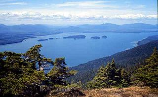
Chatham Strait, or Shee ya xhaak in the Tlingit language, is a narrow passage of the Alexander Archipelago in the southeastern region of the U.S. state of Alaska. It separates Chichagof Island and Baranof Island to its west from Admiralty Island and Kuiu Island on its east.

Burrard Inlet is a relatively shallow-sided coastal fjord in southwestern British Columbia, Canada. Formed during the last Ice Age, it separates the City of Vancouver and the rest of the low-lying Burrard Peninsula from the slopes of the North Shore Mountains, home to the communities of West Vancouver and the City and District of North Vancouver.
Pearse Island is an island in western British Columbia, Canada, in the Portland Inlet, an inlet of the Pacific Ocean. The island was first charted in 1793 by George Vancouver during his 1791-95 expedition. It was named by George Henry Richards, captain of HMS Plumper, circa 1860, in honour of William Alfred Rombulow Pearse of the Royal Navy, who had been commander of HMS Alert.

The Gardner Canal is one of the principal inlets of the British Columbia Coast. Technically a side-inlet of the larger Douglas Channel, the Gardner Canal is still 90 km (56 mi) in length in its own right; total length of the waterways converging on the Douglas Channel is 320 km (200 mi) making it one of the largest fjord-complexes in the world. The entrance to the Gardner Canal is hidden behind Hawkesbury Island, and is accessed via Devastation Sound or Varney Passage which form the northeast and southeast flanks of that island. It was named in 1793 by George Vancouver in honour of his friend and former commander, Alan Gardner, 1st Baron Gardner. One of his men, Joseph Whidbey, first charted it the same year.
Gilford Island is an island in British Columbia, Canada, located between Tribune Channel and Knight Inlet. The island has an area of 382 square kilometres (147 sq mi). Turnour Island is to the south across Tribune Channel, the entrance to Thompson Sound to the east.
Behm Canal is a natural channel in the Alexander Archipelago, in the southeastern part of the U.S. state of Alaska.

Shadan Lund is dominated Area of Sori Lund tribe. The name Tuman Sori is named after Sardar Sori Khan Lund, grandson of Sardar Haider Khan Lund and son of Sardar Shadan Khan Lund. So town name is after Sardar Shadan Khan Lund.

The Duncan Canal is a naturally occurring inland waterway in the Alexander Archipelago in Alaska, USA. It deeply penetrates Kupreanof Island, separating the Lindenberg Peninsula, on the southeast side of the island from the main island. It was first charted in 1793 by James Johnstone, one of George Vancouver's officers during his 1791-95 expedition. It was named after the English missionary William Duncan.
The Craig River is a river located in Alaska, United States and British Columbia, Canada, also formerly known as the South Fork of the Iskut River, as it is the main south tributary of the lower Iskut. The Craig has a tributary in Alaska, the South Fork Craig River. The river's origin in Alaska is located near 56°27′00″N131°25′00″W and crosses into British Columbia at 56°29′30″N131°17′30″W.

Darlington is an unincorporated community in El Dorado County, California. It lies at an elevation of 4196 feet.

Indak is a former Maidu settlement in El Dorado County, California. It lay at an elevation of 1860 feet. Its site is now occupied by Placerville.

Bradfield Corner is an unincorporated community in Wabash Township, Parke County, in the U.S. state of Indiana.
Woewodski Island is an island in the Alexander Archipelago of Southeast Alaska, United States. It is separated from Kupreanof Island to the west by Duncan Canal, and Mitkof Island to the east by the Wrangell Narrows. It is named after Captain Lieutenant Stepan Vasilivich Woewodski, who was chief director of the Russian American colonies from 1854 to 1859. The name first appears on a Russian Hydrographic Department chart of 1848 as "O(strov)va Voyevodskago". Earlier, in 1838, G. Lindenberg called part of the island "Medvezhiy". The first European to sight the island was James Johnstone, one of George Vancouver's officers during his 1791-95 expedition, in 1793. He circumnavigated it, proving its insular nature.
Bell Island is an island in the Alexander Archipelago in Southeast Alaska, United States. It is 14 kilometres (8.7 mi) long, lying in Behm Canal, north of Revillagigedo Island. George Vancouver first visited the island on August 12, 1793, in the evening dining on its south coast. He suspected that it was an island, but this was not proven until later in the same month, when Joseph Whidbey, master of HMS Discovery, charted its entire coastline. Vancouver later named it "Bell's Island" after one of his crew, Midshipman Bell.
Blake Channel is a channel in Southeast Alaska, U.S.A. It extends 19.3 kilometres (12.0 mi), separating the southeastern part of Wrangell Island from the mainland. It was first traversed and charted in 1793 by James Johnstone, one of George Vancouver's officers during his 1791-95 expedition.
Affleck Canal is an inlet in Southeast Alaska, United States It extends 32 kilometres (20 mi) north from Sumner Strait, nearly cutting Kuiu Island in two. It was first charted in 1793 by Joseph Whidbey, master of HMS Discovery during George Vancouver's 1791–1795 expedition. Vancouver named it for Admiral Philip Affleck, RN.
The Chemawawin Cree Nation is located next to Easterville, Manitoba in Central Manitoba. The population of this First Nation is identified as Swampy Cree and also Rocky Cree (Asinīskāwiyiniwak). The main reserve, Chemawawin 2, is located on the south shore of Cedar Lake in Census Division No. 21, whereas the larger but less populous Chemawawin 3 lies directly south on the northeast shores of Lake Winnipegosis in Census Division No. 19.
Broughton Island is an island in the Broughton Archipelago of the Queen Charlotte Strait area of the Central Coast of British Columbia, located northwest of Gilford Island. \

Georgetown is an unincorporated community in Harrison County, in the U.S. state of Ohio.


