
Pepel is a coastal town in the Port Loko District in the Northern Province of Sierra Leone.

Dabola is a city in central Guinea. As of 2014 it had a population of 38,617 people. It grew around the railway line from Conakry to Kankan and is known for the Tinkisso Falls and for its important dam.

The Southern Province is one of the four provinces of Sierra Leone. It covers an area of 19,694 km² and has a population of 1,438,572. It consists of four districts. Its capital and administrative center is Bo, which is also the second largest and second most populated city in Sierra Leone after the nation's capital Freetown. The population of the southern province is largely from the Mende ethnic group.

The Western Area or Freetown Peninsula is one of four principal divisions of Sierra Leone. It comprises the oldest city and national capital Freetown and its surrounding towns and countryside. It covers an area of 557 km2 and has a population of 1,447,271. The Western Area is located mostly around the peninsula and is divided into two districts: the Western Area Rural and the Western Area Urban.

Forécariah is a sub-prefecture and town located in western Guinea. Population 21,710.
F.H. Barber Provincial Park is a provincial park in British Columbia, Canada. Comprising 5 ha. of Fraser River floodplain in its natural state, it is one of only two secured public access points to the Fraser between Chilliwack and Hope. It is located at the confluence of Wahleach Creek and the Fraser one mile west of Laidlaw, British Columbia and is bounded on the south by the tracks of the Canadian National Railway.
The Lower Similkameen Indian Band or Lower Smelqmix, is a First Nations band government in the Canadian province of British Columbia. Their office is located in the village of Keremeos in the Similkameen region. They are a member of the Okanagan Nation Alliance.

The Canoe Creek Band/Dog Creek Indian Band, also known as the Canoe Creek First Nation and/or Dog Creek First Nation is a First Nations government of the Secwepemc (Shuswap) Nation, located in the Fraser Canyon-Cariboo region of the Central Interior of the Canadian province of British Columbia. It was created when the government of the then-Colony of British Columbia established an Indian Reserve system in the 1860s. It is a member government of the Northern Shuswap Tribal Council.
Lunsar is a town in Port Loko District in the Northern Province of Sierra Leone. It is the largest town in Port Loko District by population. The Britannica estimate of the population of Lunsar is 36,108. The town is one of the main commercial and business hub in the North of Sierra Leone. Lunsar lies approximately 50 miles east of Freetown and about 18 miles south-east of the district capital of Port Loko. The inhabitants of Lunsar are largely from the Temne ethnic group.
Cacuso is a town in Malanje Province, Angola.

Fish River, a perennial stream that is part of the Macquarie catchment within the Murray–Darling basin, is located in the central western district of New South Wales, Australia.
Bososo is a town in Eastern Region, southern Ghana.
Tonkolele is a town in the mountains of central Sierra Leone.
Donia is a town in southwestern Guinea. It is near the border with Sierra Leone.
Tagrin Point is the proposed location of a deep water port to replace the older and shallower port of Port Pepel in Sierra Leone. It would be connected to existing and new iron ore mined by an upgraded railway line converted to standard gauge.

Valdejalón is a comarca in Aragon, Spain. It is located in Zaragoza Province, in the transitional area between the Iberian System and the Ebro Valley.
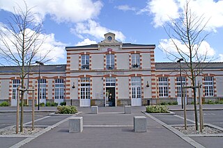
Gare de Dol-de-Bretagne is a railway station serving the town Dol-de-Bretagne, Ille-et-Vilaine department, western France.
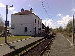
Urt is a railway station in Urt, Nouvelle-Aquitaine, France. The station is located on the Toulouse - Bayonne railway line. The station is served by TER (local) services operated by the SNCF.

08°06′00″N12°06′00″W

The National Railway Museum is a railway museum in Freetown, Sierra Leone. The museum was opened in 2005.


