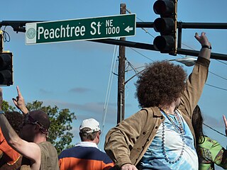
Peachtree Street is one of several major streets running through the city of Atlanta. Beginning at Five Points in downtown Atlanta, it runs North through Midtown; a few blocks after entering into Buckhead, the name changes to Peachtree Road at Palisades Road. Much of the city's historic and noteworthy architecture is located along the street, and it is often used for annual parades,, as well as one-time parades celebrating events such as the 100th anniversary of Coca-Cola in 1986 and the Atlanta Braves' 1995 World Series victory.

Buckhead is an affluent uptown commercial and residential district of Atlanta, Georgia, comprising approximately the northernmost fifth of the city.

State Route 141 (SR 141) is a 28.0-mile-long (45.1 km) state highway that runs southwest-to-northeast in the northwest part of the U.S. state of Georgia. It connects the Buckhead area of Atlanta with Cumming. Its routing exists within portions of Fulton, DeKalb, Gwinnett, Forsyth counties.

Buckhead Village is a neighborhood of Atlanta, Georgia, one of 42 neighborhoods in the larger Buckhead district and the community's historic business section. The Village as defined by the city as the area between Piedmont Road, Peachtree Road, and Pharr Road.
Standing Peachtree was a Creek Indian village and the closest Indian settlement to what is now the Buckhead area of Atlanta, Georgia. It was located where Peachtree Creek flows into the Chattahoochee River, in today's Paces neighborhood. It was located in the borderlands of the Cherokee and Creek nations. It is referred to in several documents dating as far back as 1762.

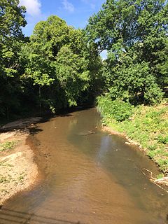
Peachtree Creek is a major stream in Atlanta. It flows for 7.5 miles (12.1 km) almost due west into the Chattahoochee River just south of Vinings.

Brookhaven is a city in the northeastern suburbs of Atlanta and is located in western DeKalb County, Georgia, United States, directly northeast of Atlanta. On July 31, 2012, Brookhaven was approved in a referendum to become DeKalb County's 11th city. Incorporation officially took place on December 17, 2012, on which date municipal operations commenced. With a population of around 54,169, it is the largest city in DeKalb County. The new city stretches over 12 square miles (31 km2).

Peachtree Center is a district located in Downtown Atlanta, Georgia. Most of the structures that make up the district were designed by Atlanta architect John C. Portman, Jr.. A defining feature of the Peachtree Center is a network of enclosed pedestrian sky bridges suspended above the street-level, which have garnered criticism for discouraging pedestrian street life. The district is served by the Peachtree Center MARTA station, providing access to rapid transit.

Buckhead is a train station in Atlanta, Georgia, serving the Red Line of the Metropolitan Atlanta Rapid Transit Authority (MARTA) rail system. This station is the first station only served by the Red Line. It is located in the Buckhead neighborhood in the median of State Route 400, a limited access highway, at Peachtree Road/State Route 141. The station is in easy walking distance of many offices, hotels and shopping centers, including Lenox Square, although the Lenox MARTA station provides easier access to the mall. The buc, a zero-fare bus service, also provides transportation to the surrounding area. The Buckhead Station also features Zipcars.

Chamblee is a train station in Chamblee, Georgia, serving the Gold Line of the Metropolitan Atlanta Rapid Transit Authority (MARTA) rail system. The station is bounded by New Peachtree Road on the East, Peachtree Road on the West and Chamblee Tucker road to the South. Chamblee Dunwoody Road is approximately ¼ mile to the north. A multi use trail has been completed between Keswick Park and Chamblee Tucker Road; this trail crosses under Peachtree Industrial Boulevard at Clairmont Road and ends at the Wal-Mart Shopping Center just southeast of the station. Chamblee has plans to connect this multi use trail at Keswick Park to an existing PATH trail that runs near Ashford Dunwoody Road between Blackburn Park and Murphey Candler Park. This station provides access to DeKalb-Peachtree Airport, Interactive College of Technology, Chamblee City Hall, and connecting bus service to Northlake Mall, Georgia State University, Peachford Hospital, Mercer University, Strayer University, North DeKalb Health Center, and the Veterans Administration Hospital.

The Peachtree Road Race is a 10-kilometer run held annually in Atlanta, Georgia, on July 4, Independence Day. The AJC Peachtree Road Race is the world's largest 10-kilometer race, a title it has held since the late 1970s. The race has become a citywide tradition in which over 70,000 amateur and professional runners try to register for one of the limited 60,000 spots. The event also includes a wheelchair race, which precedes the footrace. In recent years, the race also has a special divisions for soldiers stationed in the Middle East. The race attracts some of the world's elite 10K runners and has served as both the United States' men's and women's 10K championship.

Garden Hills is in the Buckhead section of Atlanta, Georgia between Peachtree and Piedmont Roads, bordered on the north by Pharr Road and on the south by Lindbergh Road. In 1987 the neighborhood was given historic district status by the city of Atlanta.

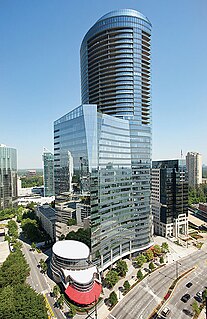
3344 Peachtree is a 50-story high-rise building of 635 feet height located in Atlanta's uptown business district of Buckhead on Peachtree Road, the northern extension of Peachtree Street. The building is a mixed-use tower that incorporates upscale dining, office space, and 82 condominia at 3344 Peachtree Road. Completed in the spring of 2008, it is the tallest mixed-use building in Atlanta. It has also surpassed the Park Avenue Condominiums as the tallest building in Atlanta not to be located downtown or midtown. The building is owned by Cousins Properties of Atlanta, Georgia.

Poyntelle is a village in Preston Township, Wayne County, Pennsylvania, in the Lake Region of the Poconos. It was once a depot of the Scranton Division of the New York, Ontario & Western (O&W) Railway, but today, when it is known outside of its immediate vicinity, it is largely for being the location of Camps Westmont and Poyntelle Lewis Village, since the reputation and commercial reach of both, like those of most rural American summer camps, extend beyond the community in which the camps are physically located.

Glenloch is a neighborhood of Peachtree City, Georgia, United States. The village is centered at South Peachtree Parkway and Windgate Road.

Peachtree Park is a neighborhood in the Buckhead Community of Atlanta, Georgia.
Peachtree Hills is a neighborhood within the Buckhead district of Atlanta, Georgia. It consists primarily of residential buildings, but restaurants, retail, and mixed use buildings are scattered throughout the neighborhood. Peachtree Battle Shopping Center is located within the borders of Peachtree Hills.


