Skara Brae is a stone-built Neolithic settlement, located on the Bay of Skaill on the west coast of Mainland, the largest island in the Orkney archipelago of Scotland. Consisting of eight clustered houses, it was occupied from roughly 3180 BC to about 2500 BC. Europe's most complete Neolithic village, Skara Brae gained UNESCO World Heritage Site status as one of four sites making up "The Heart of Neolithic Orkney". Older than Stonehenge and the Great Pyramids, it has been called the "Scottish Pompeii" because of its excellent preservation.
Sullom Voe is an inlet between North Mainland and Northmavine on Shetland in Scotland. It is a location of the Sullom Voe oil terminal and Shetland Gas Plant. The word Voe is from the Old Norse vagr and denotes a small bay or narrow creek.

The Knap of Howar on the island of Papa Westray in Orkney, Scotland is a Neolithic farmstead which may be the oldest preserved stone house in northern Europe. Radiocarbon dating shows that it was occupied from 3700 BC to 2800 BC, earlier than the similar houses in the settlement at Skara Brae on the Orkney Mainland.

The Standing Stones of Stenness is a Neolithic monument five miles northeast of Stromness on the mainland of Orkney, Scotland. This may be the oldest henge site in the British Isles. Various traditions associated with the stones survived into the modern era and they form part of the Heart of Neolithic Orkney World Heritage Site. They are looked after by Historic Environment Scotland as a scheduled monument.

The Neolithic Barnhouse Settlement is sited by the shore of Loch of Harray, Orkney Mainland, Scotland, not far from the Standing Stones of Stenness, about 5 miles north-east of Stromness.
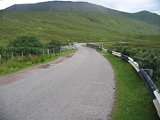
The A838 is a major road in Sutherland, in the Highland area of Scotland. It runs generally northwest from the A836 in the Lairg area to Laxford Bridge on the west coast of Scotland, then generally northeast to Durness on the north coast, and then generally east/southeast to Tongue, where it rejoins the A836. The A836 takes a more direct route from Lairg to Tongue.

Brae is a village on the island of Mainland in Shetland, Scotland, United Kingdom.
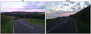
The Electric Brae is a gravity hill in Ayrshire, Scotland, where a freewheeling vehicle will appear to be drawn uphill by some mysterious attraction. The phenomenon is an optical illusion.

Drumbrae or Drum Brae is the name of a suburb of west Edinburgh, Scotland generally considered to be part of the neighbouring larger areas of Corstorphine and Clermiston. This is a commuter settlement as many people who live in the area travel to the centre of town to attend work.

Berriedale is a small estate village on the northern east coast of Caithness, Scotland, on the A9 road between Helmsdale and Lybster, close to the boundary between Caithness and Sutherland. It is sheltered from the North Sea. The village has a parish church in the Church of Scotland.

Kilmadock parish, named for Saint Cadoc, containing the settlements of Doune, Deanston, Buchany, Drumvaich, and Delvorich, is situated in Stirling council area, Scotland, and is on the southern border of the former county of Perthshire. Its length is 10 miles (16 km), its breadth from 2–8 miles (3.2–12.9 km), and with an area of 24,521 acres (99 km2).

Castle Varrich is in the far north of the Scottish Highlands, near the village of Tongue. The castle is on a local high point of rock, overlooking both the Kyle of Tongue and the village of Tongue. The castle's precise origins and age are unknown.

The Scalan was once a seminary and was one of the few places in Scotland where the Roman Catholic faith was kept alive during the troubled times of the 18th century.
Rinyo was a Neolithic settlement on the island of Rousay in Orkney, Scotland. The site was discovered in the winter of 1837-38 on the lands of Bigland Farm in the north east of the island at grid reference HY439322.
Giesecke Glacier is a glacier in the Qaasuitsup municipality in northwestern Greenland. Its outflow is split in the center by a nunatak. Through two tongues it drains the Greenland ice sheet westwards into Kangerlussuaq Icefjord. The northern tongue reaches the fjord at 73°35′N55°36′W. The southern tongue reaches the fjord at 73°30′N55°28′W.

Cathkin Braes is an area of hills to the south east of the city of Glasgow, in Scotland. It lies to the south of the districts of Castlemilk, Fernhill and Burnside, and to the east of Carmunnock.
Events from the year 1992 in Scotland.

Tongue Bay is located in northwest Highland, Scotland, in the western part of the former county of Sutherland. Skullomie is a small fishing and crofting hamlet at the head of the bay, while Melness is a group of crofting townships west of it. Talmine, a crofting and fishing township, is situated on Talmine Bay, an inlet on the western shore of Tongue Bay. The Rabbit Islands are three, uninhabited islands across from the bay; Eilean nan Ròn is at its mouth. From Tongue Bay, the coast extends to the northwest and the east. In general, it is high and rocky, and is intersected by several small creeks. Rocks along the coast are hollowed into caves, or formed into arches and pillars. The tides follow the direction of the coast nearly from east to west. The Shamrock, a 19th-century sloop located within the bay, is protected by Royal Commission on the Ancient and Historical Monuments of Scotland, as is Scullomie Harbour, also within the bay.

Kinloch Lodge, first opened in 1897, was once the private lodge of the Duke of Sutherland, and is situated in the village of Tongue in Sutherland, Scotland.