
Nitshill is a district on the south side of Glasgow. It is bordered by South Nitshill to the south, Darnley to the east, Crookston and Roughmussel to the north-west, Hurlet to the west and Househillwood and Priesthill to the north, with the Pollok district and the Silverburn Centre beyond. An area of open ground to the south-west of Nitshill forms the boundary between Glasgow and the town of Barrhead in East Renfrewshire.

Maryhill is an area in the north-west of Glasgow in Scotland. A former independent burgh and the heart of an eponymous local authority ward, its territory is bisected by Maryhill Road, part of the A81 road which runs for a distance of roughly three miles between Glasgow city centre and the suburban town of Bearsden.

Cathcart is an area of Glasgow between Battlefield, Mount Florida, King's Park, Muirend and Newlands. The White Cart Water flows through Cathcart, downstream from Linn Park. In 2014, it was rated one of the most attractive postcode areas to live in Scotland.

Cowcaddens is an area of the city of Glasgow, Scotland. It sits directly north of the city centre and is bordered by the newer area of Garnethill to the south-west and Townhead to the east.
Wishaw is a large town in North Lanarkshire, Scotland, on the edge of the Clyde Valley, 15 miles (24 km) south-east of Glasgow city centre.

Shettleston is an area in the east end of Glasgow in Scotland.

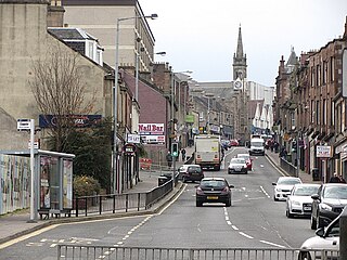
Whifflet is an area of the town of Coatbridge, Scotland, which once formed its own distinctive village. It is referred to, locally, as "The Whifflet".
Croftfoot is a residential area on the southeastern side of the Scottish city of Glasgow. It is bordered by Castlemilk to the south and King's Park to the west within Glasgow, and by the Rutherglen areas of Spittal to the east and Bankhead to the north. Historically within the civil parish of Cathcart in Renfrewshire, it is within the Linn ward of Glasgow City Council.

Garrowhill is a residential area within the wider Baillieston suburb of Glasgow, Scotland. It is situated approximately 7 miles (11 km) east of the city centre.

Abbeyhill is an area of Edinburgh, the capital of Scotland.
Larkfield is the largest council housing estate in Greenock, Inverclyde, Scotland.

Hartwood is a village in North Lanarkshire, Scotland. Nearby settlements include Shotts, Allanton and Bonkle. The area is rural, with fewer than 50 houses. Transport is provided at Hartwood railway station, operated by Network Rail, with an hourly service Monday - Saturday every hour between Glasgow Central and Edinburgh Waverley on the Shotts Line.

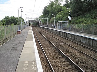
Jordanhill railway station is a side-platformed suburban railway station in the Jordanhill area in the West End of Glasgow, Scotland. The station, which is governed by Transport Scotland and managed by ScotRail, lies on the Argyle Line and the North Clyde Line. In operation since 1887, the station stemmed losses for an area that was in decline.
Hawkhead is an area near Paisley in Renfrewshire, Scotland.

Curriehill is a suburb of Edinburgh, the capital of Scotland. It is north-west of Currie.
Easter Road is an arterial road in north Edinburgh, the capital of Scotland. The road is so called as it was known as the "Easter (eastern) road to Leith". As maps of Edinburgh in the late 18th century show, it had a counterpart in "Wester Road". Until the creation of Leith Walk in the middle of the 17th century these were the two main routes from Leith to Edinburgh. Historic personages who have ridden up Easter Road have included Mary, Queen of Scots (1561) and Oliver Cromwell.

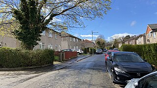
Drumry is a district in the Scottish town of Clydebank, West Dunbartonshire, split into North and South Drumry by its main thoroughfare, Drumry Road. Some of the housing, including five tower blocks, was refurbished in the early 2010s.

Houston and Killellan is a civil parish in the county and council area of Renfrewshire in the west central Lowlands of Scotland. It contains the villages of Houston and Crosslee, as well as a number of smaller settlements including Barochan and Killellan in its rural hinterland.
Bogston is an area of the towns of Port Glasgow and Greenock in the council area of Inverclyde, Scotland. It is 35 km west of Glasgow.

Cartsdyke, formerly known as Crawfurdsdyke, is a suburb of the town of Greenock, Scotland.
