
Childe's Tomb is a granite cross on Dartmoor, Devon, England. Although not in its original form, it is more elaborate than most of the crosses on Dartmoor, being raised upon a constructed base, and it is known that a kistvaen is underneath.

Dartmoor is an upland area in southern Devon, South West England. The moorland and surrounding land has been protected by National Park status since 1951. Dartmoor National Park covers 954 km2 (368 sq mi).

Ten Tors is an annual weekend hike in early May, on Dartmoor, southwest England. Organized by the British Army, starting in 1960, it brings together teams of six young people, with the 2,400 young participants hiking to checkpoints on ten specified tors. The majority of entrants are schools, colleges, Scout groups and Cadet squadrons from South West England, though groups from across the UK have regularly taken part, as have teams from Australia and New Zealand. However, from 2012, only teams from the South West of England are eligible to take part, due to the large numbers of entrants.

Fox Tor is a relatively minor tor on Dartmoor in the county of Devon, England.

Bowerman's Nose is a stack of weathered granite on Dartmoor, Devon, England. It is situated on the northern slopes of Hayne Down, about a mile from Hound Tor and close to the village of Manaton at grid reference SX742805. It is about 21.5 feet (6.6 m) high and is the hard granite core of a former tor, standing above a 'clitter' of the blocks that have eroded and fallen from it.

Belstone is a small village and civil parish in the West Devon District of Devon, England.

North Hessary Tor is a 517 metres hill just above Dartmoor Prison, in Princetown within Dartmoor Forest civil parish, which is in the borough of West Devon, Devon, England. The tor is one of the boundary points mentioned in the perambulations of the Forest of Dartmoor.
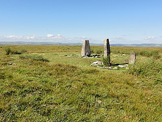
At 515 m, Ryder's Hill is the highest point on the southern part of Dartmoor, Devon, England. On its summit there are two standing stones and a low cairn, on top of which is a triangulation pillar.

Brent Tor is a tor on the western edge of Dartmoor, approximately four miles (6.5 km) north of Tavistock, rising to 1100 ft (330m) above sea level. The Tor is surmounted by the Church of St Michael, the parish church of the village of Brentor, which lies below the Tor.

Great Links Tor is a prominent tor on the north-western flank of Dartmoor, Devon, England. It is visible for a considerable distance on the approach to the moor from the west. It is one of the highest points on Dartmoor, standing 1,939 feet (591 m) above sea level and is dominated by a monolithic outcropping of granite some 40 feet (12 m) high. There is an OS Triangulation point on a block to the west of the main outcrop, which is where most who visit the tor will climb to. The highest outcrop is inaccessible without a climb, the easiest route being up the eastern chimely. Other routes can be found here. Close by are the remains of the Rattlebrook Peat Works at Rattlebrook Head and the ruins of the appropriately named 'Bleak House'.
Burrator is a grouped parish council in the English county of Devon. It is entirely within the boundaries of the Dartmoor National Park and was formed in 1973 as a result of the Local Government Act 1972 from the older councils of Meavy, Sheepstor and Walkhampton.

Rough Tor, or Roughtor, is a tor on Bodmin Moor, Cornwall, England, United Kingdom. The site comprises the tor summit and logan stone, a neolithic tor enclosure, many Bronze Age hut circles, and some contemporary monuments.

Down Tor is a tor on Dartmoor, England, at GR 581694, height 366 metres (1,201 ft), overlooking Burrator Reservoir.

The Dartmoor crosses are a series of stone crosses found in Dartmoor National Park in the centre of Devon, England. Many of them are old navigational aids, needed because of the remoteness of the moorland and its typically bad weather. Some mark medieval routes between abbeys. Other crosses were erected as memorials, for prayer, as town or market crosses, in churchyards, and as boundary markers. The crosses were erected over a long period of time, some as recently as 100 years ago, the earliest probably almost 1,000 years ago.

Yelverton Rock is a tor-like igneous rock outcrop immediately south-west of Yelverton, Devon. It is located at the southern end of the former RAF Harrowbeer airfield on Roborough Down, next to the border with the A386. This location created problems for the airfield during the Second World War, as two runways were positioned in front of the rock.

Rippon Tor Rifle Range is a disused rifle range from World War II on Dartmoor, Devon, England. The range is situated southeast of the 473 m high Rippon Tor, near the village Widecombe-in-the-Moor, and close to the road between Halshanger and Cold East Cross.

Hookney Tor is a tor, situated on Dartmoor in Devon, England.

The River Sig is a 2.4 mile long river on Dartmoor in the county of Devon, England. It is a tributary to the River Lemon which it meets at Sigford.
Aish Tor is a small tor above the northern side of the Dart Gorge in Dartmoor, Devon, England, that is accessed by Dr. Blackall's Drive from Newbridge Hill. It stands at 283 metres (928 ft) above sea level and is topped by a small cairn. The actual 'tor' is small and flat and generally hard to pin-point. Nearby tors include:
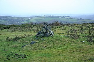
Rippon Tor is a striking tor on eastern Dartmoor, in England, that stands at 473 metres (1,552 ft) above sea level. It has three cairns, of which are some of Dartmoor's largest, a triangulation pillar, and several rock piles that overlook the northern high moors near Fernworthy Forest and Great Mis Tor. Field boundaries surround the tor.

