


Brest City Park is an urban public park in Brest, Belarus. The Russian soldiers of Libava Regiment, who were stationed in this part of Brest-Litovsk, laid out the park in 1906.
Brest City Park is an urban public park in Brest, Belarus. The Russian soldiers of Libava Regiment, who were stationed in this part of Brest-Litovsk, laid out the park in 1906.
Initially it covered 4 ha. Today, at over 20 ha, it is the largest public park in the city. The park features dozens of tree species rare in this part of Europe, such as platanus, tamarisk, elm, and serpentine spruce (Picea Abies "Virgata").
2006 marked the park's centenary. The park underwent an all-out reconstruction that lasted two years till 2006. On October 16, 2004, the park was reopened on completion of the first stage of reconstruction. In 2006, the entire reconstruction was completed and the park hosts visitors again. As its official name is First of May Park, it was reopened on May 1.
In the park, visitors can find a large disco club, an open-air concert stage, an amusement park and two lovely ponds called Upper Lake and Lower Lake. These ponds are connected by a canal, with water slowly flowing from Upper Lake to Lower Lake. There are two fountains in Upper Lake, and new bridges span the canal's banks. Another bridge links the island in the centre of Upper Lake with the shore. New iron fences and railings give a fresh look to the sites around the ponds.
52°05′40″N23°40′36″E / 52.09444°N 23.67667°E

Central Park is an urban park between the Upper West Side and Upper East Side neighborhoods of Manhattan in New York City, and the first landscaped park in the United States. It is the sixth-largest park in the city, containing 843 acres (341 ha), and the most visited urban park in the United States, with an estimated 42 million visitors annually as of 2016. It is also one of the most filmed locations in the world.
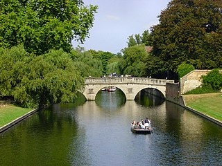
The River Cam is the main river flowing through Cambridge in eastern England. After leaving Cambridge, it flows north and east before joining the River Great Ouse to the south of Ely, at Pope's Corner. The total distance from Cambridge to the sea is about 40 mi (64 km) and is navigable for punts, small boats, and rowing craft. The Great Ouse also connects to England's canal system via the Middle Level Navigations and the River Nene. In total, the Cam runs for around 69 kilometres (43 mi) from its furthest source to its confluence with the Great Ouse.

Collect Pond, or Fresh Water Pond, was a body of fresh water in what is now Chinatown in Lower Manhattan, New York City. For the first two centuries of European settlement in Manhattan, it was the main New York City water supply system for the growing city. A jail was later built on the former pond. In the 20th century, the site became Collect Pond Park, which includes a reflecting pool to acknowledge the historic importance of this body of water.

Multnomah Falls is a waterfall located on Multnomah Creek in the Columbia River Gorge, east of Troutdale, between Corbett and Dodson, Oregon, United States. The waterfall is accessible from the Historic Columbia River Highway and Interstate 84. Spanning two tiers on basalt cliffs, it is the tallest waterfall in the state of Oregon at 620 ft (189 m) in height. The Multnomah Creek Bridge, built in 1914, crosses below the falls, and is listed on the National Register of Historic Places.
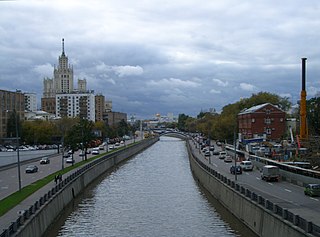
The Yauza is a river in Moscow and Mytishchi, Russia, a tributary of the Moskva. It originates in the Losiny Ostrov National Park northeast of Moscow, flows through Mytishchi, enters Moscow in the Medvedkovo District and flows through the city in an irregular, meandering, generally north-south direction. The Yauza joins the Moskva River in Tagansky District just west of Tagansky Hill, now marked by the Kotelnicheskaya Embankment tower. Valleys of the Yauza, from the MKAD beltway in the north to the Moscow-Yaroslavl railway west of Sokolniki Park, are protected as natural reserves.

The Adirondack Park is a park in northeastern New York protecting the Adirondack Mountains. The park was established in 1892 for "the free use of all the people for their health and pleasure", and for watershed protection. At 6.1 million acres, it is the largest park in the contiguous United States.

Hawaiʻi Volcanoes National Park is a national park of the United States located in Hawaii on the island of Hawaii. The park encompasses two active volcanoes: Kīlauea, one of the world's most active volcanoes, and Mauna Loa, the world's largest shield volcano. The park provides scientists with insight into the development of the Hawaiian Islands and access for studies of volcanism. For visitors, the park offers dramatic volcanic landscapes, glimpses of rare flora and fauna, and a view into the traditional Hawaiian culture connected to these landscapes.

Cuyahoga Valley National Park is a national park of the United States in Ohio that preserves and reclaims the rural landscape along the Cuyahoga River between Akron and Cleveland in Northeast Ohio.

The Keweenaw Waterway is a partly natural, partly artificial waterway which cuts across the Keweenaw Peninsula of Michigan; it separates Copper Island from the mainland. Parts of the waterway are variously known as the Keweenaw Waterway, Portage Canal, Portage Lake Canal, Portage River, Lily Pond, Torch Lake, and Portage Lake. The waterway connects to Lake Superior at its north and south entries, with sections known as Portage Lake and Torch Lake in between. The primary tributary to Portage Lake is the Sturgeon River.

The River Devon is a tributary of the River Trent, which rises in Leicestershire and joins the Trent at Newark in Nottinghamshire, England. In its upper reaches, it supplies Knipton Reservoir, which was built to supply water to the Grantham Canal, and Belvoir Lakes, designed by Capability Brown. It passes under the Grantham Canal, and then through Bottesford, where it is spanned by five railway bridges, only one of which is still used for its original purpose. On the outskirts of Newark, it passes by two Civil War structures, and just before it joins the Trent it becomes navigable, with a marina located on the west bank. Its name is pronounced "Deevon", not as spelt.

The Ninth Ward or 9th Ward is a distinctive region of New Orleans, Louisiana, which is located in the easternmost downriver portion of the city. It is geographically the largest of the 17 Wards of New Orleans. On the south, the Ninth Ward is bounded by the Mississippi River. On the western or "upriver" side, the Ninth Ward is bounded by Franklin Avenue, then Almonaster Avenue, then People's Avenue. From the north end of People's Avenue the boundary continues on a straight line north to Lake Pontchartrain; this line is the boundary between the Ninth and the city's Eighth Ward. The Lake forms the north and northeastern end of the ward. St. Bernard Parish is the boundary to the southeast, Lake Borgne farther southeast and east, and the end of Orleans Parish to the east at the Rigolets.
The Upper Delaware Scenic and Recreational River is a unit of the National Park Service designated under the National Wild and Scenic Rivers System. It stretches along 73.4 miles (118.1 km) of the Delaware River between Hancock, New York, and Sparrowbush, New York. It includes parts of Delaware County, Orange County, and Sullivan County in New York, as well as Pike County and Wayne County in Pennsylvania. Most of the land in this unit is privately owned; the federal government only owns about 30 acres (12 ha).

The Sault Ste. Marie Canal is a National Historic Site in Sault Ste. Marie, Ontario, and is part of the national park system, managed by Parks Canada. It includes a lock to bypass the rapids on the St. Marys River.

Fishkill Creek is a tributary of the Hudson River in Dutchess County, New York, United States. At 33.5 miles (53.9 km) it is the second longest stream in the county, after Wappinger Creek. It rises in the town of Union Vale and flows generally southwest to a small estuary on the Hudson just south of Beacon. Part of its 193-square-mile (500 km2) watershed is in Putnam County to the south. Sprout Creek, the county's third-longest creek, is its most significant tributary. Whaley and Sylvan lakes and Beacon Reservoir, its largest, deepest and highest lakes, are among the bodies of water within the watershed.

Sandy Island Beach State Park is a New York State park on the eastern shore of Lake Ontario. Its highlight is a 1,500-foot (460 m) natural sandy beach. The park is near the southern end of a notable 17-mile (27 km) length of sandy shoreline, coastal dunes, and wetlands ; a 1959 study noted that "The eastern end of Lake Ontario contains not only the finest beaches on the entire lake but also the finest wildlife habitat."

The Ramble and Lake are two geographic features of Central Park in Manhattan, New York City. Part of Frederick Law Olmsted and Calvert Vaux's 1857 Greensward Plan for Central Park, the features are located on the west side of the park between the 66th and 79th Street transverses.

Onondaga Park is an 82.6-acre (33.4 ha) park in the city of Syracuse, New York. Man-made Hiawatha Lake is located within the park, which is situated in Syracuse's Strathmore neighborhood on the city's south side.

The Pond and Hallett Nature Sanctuary are two connected features at the southeastern corner of Central Park in Manhattan, New York City. It is located near Grand Army Plaza, across Central Park South from the Plaza Hotel, and slightly west of Fifth Avenue. The Pond is one of seven bodies of water in Central Park.

Bellows Falls Canal is a canal constructed to allow boat traffic to bypass Great Falls on the Connecticut River in Bellows Falls, Vermont. It was constructed by the Bellows Falls Canal Company and was one of the first canals in the United States. It was used for transport, to power mills, and later for hydroelectric power. The Bellows Falls Downtown Historic District includes the canal.

The Nymphenburg Palace Park ranks among the finest and most important examples of garden design in Germany. In combination with the palace buildings, the Grand circle entrance structures and the expansive park landscape form the ensemble of the Nymphenburg Summer Residence of Bavarian dukes and kings, located in the modern Munich Neuhausen-Nymphenburg borough. The site is a Listed Monument, a Protected Landscape and to a great extent a Natura2000 area.