Related Research Articles
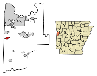
Hackett is a city in Sebastian County, Arkansas, United States. It is part of the Fort Smith, Arkansas-Oklahoma Metropolitan Statistical Area. The population was 812 at the 2010 census.

Conneaut Township is a township in Crawford County, Pennsylvania, United States. The population was 1,339 at the 2020 census.
Rose State College is a public community college in Midwest City, Oklahoma.

Antonina is a municipality in the state of Paraná in southern Brazil. As of 2020, the estimated population was 18,949.
The University of South Florida Botanical Gardens 15 acres are located on the campus of the University of South Florida in Tampa, Florida, United States, and consist of 7 acres of developed gardens plus 6 to 9 acres of natural greenbelt. It is a member of the American Public Gardens Association, American Horticulture Society Reciprocal Admissions Program, Greater Temple Terrace Chamber of Commerce, and Visit Florida and receives about 35,000 visitors annually. The gardens are open to the public during weekday business hours, and on shorter weekend hours. Admission is $5 for adults.
Tkʼemlúps te Secwépemc, abbreviated TteS and previously known as the Kamloops Indian Band, is a First Nations government within the Shuswap Nation Tribal Council, which represents ten of the seventeen Secwepemc band governments, all in the southern Central Interior region, spanning the Thompson and Shuswap districts. It is one of the largest of the 17 groups into which the Secwepemc (Shuswap) nation was divided when the Colony of British Columbia established an Indian reserve system in the 1860s.
East Pine Provincial Park is a provincial park in British Columbia, Canada, located east of Chetwynd in the Peace River Block at the junction of the Pine and Murray Rivers. The park was established in 1982 and is 14.2 hectares in size.
Fort George Canyon Provincial Park is a provincial park south of Prince George in British Columbia, Canada. The park's area is 440 acres (180 ha) and includes part of the Fraser River. No camping, campfires, swimming, kayaking, horses, pets, or rock climbing are allowed. Skiing, fishing, and hunting are allowed.

Teardrop Park is a 1.8-acre (0.7 ha) public park in lower Manhattan, in Battery Park City, near the site of the World Trade Center. It was designed by Michael Van Valkenburgh Associates, a New York City landscape architecture firm. The park includes art designed for it by Ann Hamilton. The park sits between residential buildings toward the north end of Battery Park City at the corner of Warren Street and River Terrace. The creation of Teardrop Park is part of the ongoing construction of Battery Park City, a neighborhood on the southwest edge of Manhattan Island that was created in the 1970s by landfilling the Hudson River between the existing bulkhead and the historic pierhead line. Before construction, the site was empty and flat. The park was designed in anticipation of four high residential towers that would define its eastern and western edges. Although Teardrop Park is a New York City public park, the client for the park was the Battery Park City Authority, and maintenance is overseen by the Battery Park City Parks Conservancy.

The Lil'wat First Nation, a.k.a. the Lil'wat Nation or the Mount Currie Indian Band, is a First Nation band government located in the southern Coast Mountains region of the Interior of the Canadian province of British Columbia. It is a member of the Lillooet Tribal Council, which is the largest grouping of band governments of the St'at'imc or Stl'atl'imx people. Other St'at'imc governments include the smaller In-SHUCK-ch Nation on the lower Lillooet River to the southwest, and the independent N'quatqua First Nation at the near end of Anderson Lake from Mount Currie, which is the main reserve of the Lil'wat First Nation, and also one of the largest Indian reserves by population in Canada.
Little Belt National Forest was established as the Little Belt Forest Reserve by the U.S. Forest Service in Montana on October 3, 1905 with 583,600 acres (2,362 km2) after a name change from Little Belt Mountains Forest Reserve, which was established on August 16, 1902 with 501,000 acres (2,030 km2). It became a National Forest on March 4, 1907. On July 1, 1908 the entire forest was combined with Highwood Mountains, Snowy Mountains and Little Rockies National Forests to establish Jefferson National Forest and the name was discontinued. The lands are included in Lewis and Clark National Forest.
Tejo River is a river of Acre state in western Brazil.
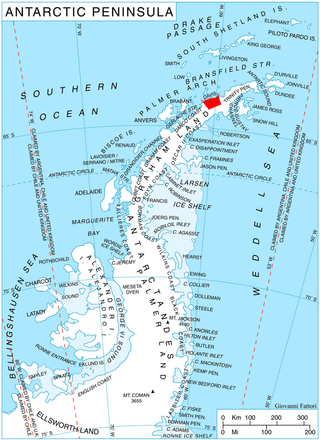
Pirin Glacier is the 5.7 km long and 6 km wide glacier situated next east of Chavdar Peninsula on Davis Coast on the Antarctic Peninsula. Situated west of Wright Ice Piedmont, north of Gregory Glacier and east of Samodiva Glacier. Draining north-northwestwards from Boulton Peak to enter Curtiss Bay east of Seaplane Point.

Malorad Glacier is the 14 km long and 10.5 km wide glacier on Trinity Peninsula, Antarctic Peninsula. Situated north of Russell West Glacier, and bounded by Marescot Ridge to the northeast, Louis-Philippe Plateau to the southeast, Srednogorie Heights to the south and Hanson Hill to the southwest. Draining northwestwards to enter Bransfield Strait east of Cape Roquemaurel and west of Thanaron Point.
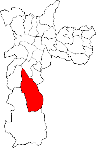
The Subprefecture of Capela do Socorro is one of 32 subprefectures of the city of São Paulo, Brazil. It comprises three districts: Socorro, Grajaú, and Cidade Dutra.

Kutlovitsa Glacier is the 9.4 km long and 4.2 km wide glacier in southern Aristotle Mountains on Oscar II Coast in Graham Land, Antarctica situated north of Flask Glacier. It is draining the southeast slopes of Madrid Dome, and flowing southeastwards along the north slopes of Mount Fedallah to join Belogradchik Glacier.
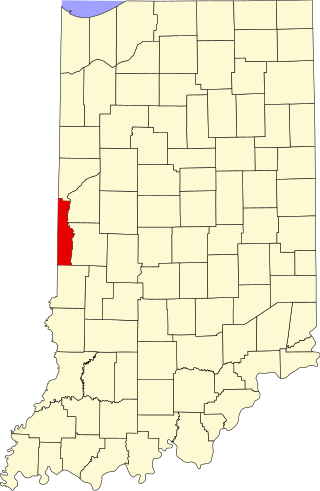
Rhodes is an unincorporated community in Clinton Township, Vermillion County, in the U.S. state of Indiana.

Marvodol Glacier is the 9.3 km long and 3.7 km wide glacier on Fallières Coast in Graham Land, Antarctica. It is situated south of Kashin Glacier, north of Forbes Glacier and east-southeast of Bucher Glacier, flows southwards between Shapkarev Buttress and Rudozem Heights, turns west at Stanhope Towers, and flows into Dogs Leg Fjord.
Holly Shelter Swamp is a pocosin in southern coastal North Carolina near Jacksonville, in Pender County. Much of the swamp is included in the 63,494-acre (25,695 ha) Holly Shelter Game Land, administered by the North Carolina Wildlife Resources Commission. The Bear Garden tract of the northern swamp has been logged and has a road grid. The swamp is drained by the Northeast Cape Fear River.
Builth Wells F.C. is a Welsh football club based in Builth Wells, Powys. They are currently playing in the Ardal Leagues North East, the third tier of the Welsh football pyramid. The club is the most successful club in the history of the Mid Wales South Football League, with ten championship wins. The club's reserve team currently plays in this league.
References
Coordinates: 9°24′47″S72°43′00″W / 9.41306°S 72.71667°W