
Physical geography is one of the three main branches of geography. Physical geography is the branch of natural science which deals with the processes and patterns in the natural environment such as the atmosphere, hydrosphere, biosphere, and geosphere. This focus is in contrast with the branch of human geography, which focuses on the built environment, and technical geography, which focuses on using, studying, and creating tools to obtain,analyze, interpret, and understand spatial information. The three branches have significant overlap, however.

Geomorphology is the scientific study of the origin and evolution of topographic and bathymetric features created by physical, chemical or biological processes operating at or near Earth's surface. Geomorphologists seek to understand why landscapes look the way they do, to understand landform and terrain history and dynamics and to predict changes through a combination of field observations, physical experiments and numerical modeling. Geomorphologists work within disciplines such as physical geography, geology, geodesy, engineering geology, archaeology, climatology, and geotechnical engineering. This broad base of interests contributes to many research styles and interests within the field.

Pembrokeshire is a county in the south-west of Wales. It is bordered by Carmarthenshire to the east, Ceredigion to the northeast, and the rest by sea. The county is home to Pembrokeshire Coast National Park. The Park occupies more than a third of the area of the county and includes the Preseli Hills in the north as well as the 190-mile (310 km) Pembrokeshire Coast Path. It is also part of the Swansea Bay City Region. Notable settlements in the county include Haverfordwest, Pembroke Dock, Pembroke, Fishguard and Goodwick, Tenby, Milford Haven, Neyland and St David's.

Welsh writing in English, is a term used to describe works written in the English language by Welsh writers.

Pembrokeshire Coast National Park is a national park along the Pembrokeshire coast in west Wales.
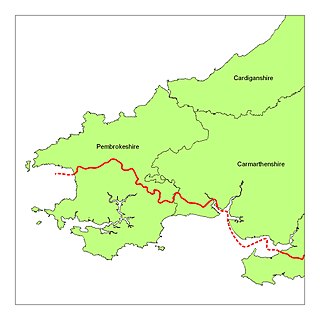
Little England beyond Wales is a name that has been applied to an area of southern Pembrokeshire and southwestern Carmarthenshire in Wales, which has been English in language and culture for many centuries despite its remoteness from England. Its origins may lie in the Irish, Norse, Norman, Flemish and Saxon settlement that took place in this area more than in other areas of South West Wales. Its northern boundary is known as the Landsker Line.
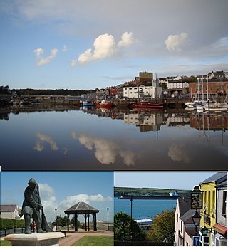
Milford Haven is both a town and a community in Pembrokeshire, Wales. It is situated on the north side of the Milford Haven Waterway, an estuary forming a natural harbour that has been used as a port since the Middle Ages. The town was founded in 1790 by Sir William Hamilton, who designed a grid pattern. It was originally intended to be a whaling centre, though by 1800 it was developing as a Royal Navy dockyard which it remained until the dockyard was transferred to Pembroke in 1814. It then became a commercial dock, with the focus moving in the 1960s, after the construction of an oil refinery built by Esso, to logistics for fuel oil and liquid gas. By 2010, the town's port had become the fourth largest in the United Kingdom in terms of tonnage, and continues its important role in the United Kingdom's energy sector with several oil refineries and one of the biggest LNG terminals in the world.

Newport is a town, parish, community, electoral ward and ancient port of Parrog, on the Pembrokeshire coast in West Wales at the mouth of the River Nevern in the Pembrokeshire Coast National Park.
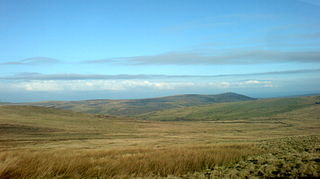
The Preseli Mountains, also known as the Preseli Hills, or just the Preselis, is a range of hills in western Wales, mostly within the Pembrokeshire Coast National Park and entirely within the county of Pembrokeshire.

Tenby is a seaside town and community in the county of Pembrokeshire, Wales. It lies within Carmarthen Bay.

South Wales is a loosely defined region of Wales bordered by England to the east and mid Wales to the north. Generally considered to include the historic counties of Glamorgan and Monmouthshire, south Wales extends westwards to include Carmarthenshire and Pembrokeshire. In the western extent, from Swansea westwards, local people would probably recognise that they lived in both south Wales and west Wales. The Bannau Brycheiniog National Park covers about a third of south Wales, containing Pen y Fan, the highest British mountain south of Cadair Idris in Snowdonia.
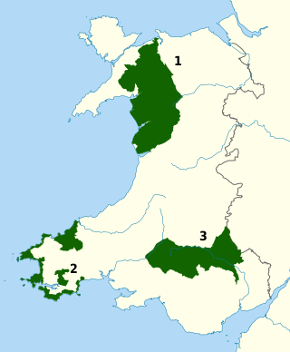
The national parks of Wales are managed areas of outstanding landscape in Wales, United Kingdom where some forms of development are restricted to preserve the landscape and natural environment. Together, they cover 20% of the land surface of Wales and have a resident population of over 80,000 people. Each National Park Authority is a free-standing body within the local government framework. At present, Wales has three national parks: Snowdonia, created in 1951, Pembrokeshire Coast (1952) and Brecon Beacons, and five areas of outstanding natural beauty (AONB), which together form the Protected areas of Wales. One of the AONBs, the Clwydian Range and Dee Valley has been proposed to be Wales' fourth national park.
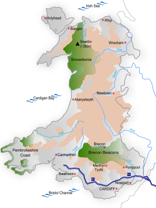
Wales is a country that is part of the United Kingdom and whose physical geography is characterised by a varied coastline and a largely upland interior. It is bordered by England to its east, the Irish Sea to its north and west, and the Bristol Channel to its south. It has a total area of 2,064,100 hectares and is about 170 mi (274 km) from north to south and at least 60 mi (97 km) wide. It comprises 8.35 percent of the land of the United Kingdom. It has a number of offshore islands, by far the largest of which is Anglesey. The mainland coastline, including Anglesey, is about 1,680 mi (2,704 km) in length. As of 2014, Wales had a population of about 3,092,000; Cardiff is the capital and largest city and is situated in the urbanised area of South East Wales.

Jim Perrin, is an English rock climber and travel writer.
Jamie Owen is a Welsh journalist, broadcaster, writer and former BBC Wales Today presenter. He joined the BBC in 1989, first working at BBC Radio and then presenting BBC Wales Today between 1994 and 2018. He has presented other TV and radio programmes and has published several books.

The Angel Mountain Saga of eight novels was written by Welsh author Brian John, and was first published at the rate of one volume per year in 2001-2005, with later volumes in 2007, 2009 and 2012. The publisher is Greencroft Books, based in Newport, Pembrokeshire. The novels tell of the life and times of Mistress Martha Morgan, a feisty heroine who starts the series in 1796 as a pregnant and suicidal eighteen-year-old and finishes it by going to her grave in 1855. In the sixth novel she is resurrected and has further adventures in Merthyr Tydfil and further afield. Volumes seven and eight are placed into gaps in the narrative related in Volume Three. The eight novels are "On Angel Mountain" (2001), "House of Angels" (2002), "Dark Angel" (2003), "Rebecca and the Angels" (2004), "Flying with Angels" (2005), "Guardian Angel" (2007), "Sacrifice" (2009) and "Conspiracy of Angels" (2012).

Iolo Tudur Williams is a Welsh ornithologist, nature observer, television presenter and author, best known for his BBC and S4C nature programmes, working in both English and his first language of Welsh. After a 14-year career with the RSPB, in 1999 Williams became a full-time TV presenter. He has written a number of books about the natural world.

The Irish Sea Glacier was a huge glacier during the Pleistocene Ice Age that, probably on more than one occasion, flowed southwards from its source areas in Scotland and Ireland and across the Isle of Man, Anglesey and Pembrokeshire. It probably reached its maximum extent during the Anglian Glaciation, and it was also extensive during the Late Devensian Glaciation.

The Extreme Ice Survey (EIS), based in Boulder, Colorado, uses time-lapse photography, conventional photography and video to document the effects of global warming on glacial ice. It is the most wide-ranging glacier study ever conducted using ground-based, real-time photography. Starting in 2007 the EIS team installed as many as 43 time-lapse cameras at a time at 18 glaciers in Greenland, Iceland, Alaska, Canada, the Nepalese Himalaya, and the Rocky Mountains of the U.S. The cameras shoot year-round, during daylight, at various rates. The team supplements the time-lapse record by occasionally repeating shots at fixed locations in Iceland, Bolivia, the Canadian province of British Columbia and the French and Swiss Alps. Collected images are being used for scientific evidence and as part of a global outreach campaign aimed at educating the public about the effects of climate change. EIS imagery has appeared in time-lapse videos displayed in the terminal at Denver International Airport; in media productions such as the 2009 NOVA Extreme Ice documentary on PBS; and is the focus of the feature-length film Chasing Ice, directed by Jeff Orlowski, which premiered at the Sundance film festival in Utah on January 23, 2012. Major findings were published in 2012 in Ice: Portraits of the World’s Vanishing Glaciers by James Balog.
Saint Johns Range is a crescent-shaped mountain range about 20 nautical miles (37 km) long, in Victoria Land. It is bounded on the north by the Cotton, Miller and Debenham Glaciers, and on the south by Victoria Valley and the Victoria Upper and Victoria Lower Glaciers. Its eastern end is formed by a spur called Lizards Foot. Named by the New Zealand Northern Survey Party of the Commonwealth Trans-Antarctic Expedition, 1956–58, which surveyed peaks in the range in 1957. Named for St. John's College at Cambridge, England, with which several members of the British Antarctic Expedition (1910–13) were associated during the writing of their scientific reports, and in association with the adjacent Gonville and Caius Range.


