
Brighton is a former town and current neighborhood of Boston, Massachusetts, United States, located in the northwestern corner of the city. It is named after the English city of Brighton. Initially Brighton was part of Cambridge, and known as "Little Cambridge". Brighton separated from Cambridge in 1807 after a bridge dispute, and was annexed to Boston in 1874. For much of its early history, it was a rural town with a significant commercial center at its eastern end.
Allston is an officially recognized neighborhood in Boston, Massachusetts, United States. It was named after the American painter and poet Washington Allston. It comprises the land covered by the zip code 02134. For the most part, Allston is administered collectively with the adjacent neighborhood of Brighton. The two are often referred to together as Allston–Brighton. Boston Police Department District D-14 covers the Allston-Brighton area and a Boston Fire Department Allston station is located in Union Square which houses Engine 41 and Ladder 14. Engine 41 is nicknamed "The Bull" to commemorate the historic stockyards of Allston.
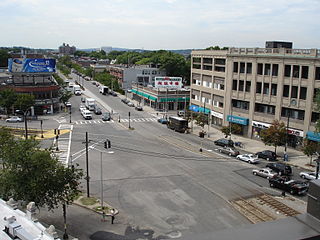
Packard's Corner is located in Boston, Massachusetts at the intersection of Commonwealth Avenue and Brighton Avenue. Packard's Corner is serviced by the Packards Corner stop on the B branch of the MBTA's Green Line, a light rail line that runs mostly above ground.

The Great Bridge over the Charles River connected Cambridge, Massachusetts, to what is now known as Allston, Boston, Massachusetts. The Great Bridge was built in 1660–1662 at what was then called Brighton Street, and was the first bridge to span the Charles. A toll was authorized in 1670. The bridge was rebuilt in 1862.

The Bright-Landry Hockey Center is a 3,095-seat ice-hockey arena in the Allston neighborhood of Boston, Massachusetts, United States. It is home to the Harvard University Crimson men's and women's ice hockey teams. It is named for Alec Bright, class of 1919, a former hockey player, and C. Kevin Landry, class of 1966, a donor to the Harvard athletic department.
Allston–Brighton is a set of two interlocking neighborhoods, Allston and Brighton, both part of the city of Boston, Massachusetts.

The Horace Mann School for the Deaf and Hard of Hearing (HMS) is the oldest public day school for the Deaf and hard of hearing in the United States. Located in the Allston neighborhood of Boston, the Horace Mann School is a member of Boston Public Schools, and has a long history of providing education for deaf and hard of hearing students.

The Allston Mall was the provisional name for a space located on the second floor at 107 Brighton Avenue, Allston, Massachusetts, USA. Owned by Marsha Berman from approximately 1960 to 2005, it was home to countless examples of low rent alternative entrepreneurialism and cultural experimentation. It also provided off-and-on illegal housing to a number of marginal types. The building itself is a two-storey, mixed-use, commercial brick building constructed somewhere around 1900. It is still in use today but is no longer owned by Berman.
Harpers Ferry was a live music venue and bar in the Allston neighborhood of Boston, Massachusetts. It was in the high traffic central student section of Boston, equidistant from both Boston College and Boston University. Hosting national touring acts and regional acts, Harpers Ferry became known as "Boston's Best Live Music". The development of the "Allston Rock City" music scene centered on Harpers Ferry as a primary venue. Harpers Ferry closed down unexpectedly on October 31, 2010. The location is now home to the Brighton Music Hall.
Hopkins House (Boston College) is home to the Office of Governmental & Community Affairs at Boston College. Its mission is to foster communication and positive relationships with the university's host communities of Boston and Newton, as well as all levels of government.

The Honan-Allston branch of the Boston Public Library is located at 300 North Harvard Street in Lower Allston. The 57,000 square feet (5,300 m2) building opened in 2001 at a cost of $6.5 million, replacing a former branch closed in 1981. The library itself contains an area of 20,000 square feet (1,900 m2). The materials used to build the library include slate panels, shingles and rough sculpings, unfinished iron-wood cladding, and wood windows.

Jordan Field is a stadium on the campus of Harvard University in the Allston neighborhood of Boston..

The Charles River Speedway was a former bicycle and harness racing track located in Allston, Massachusetts, which has been redeveloped into an upscale market.

Union Square is a square in the Allston neighborhood of Boston, Massachusetts at the intersection of Cambridge Street and Brighton Avenue/North Beacon Street. Union Square is serviced by the MBTA 57, 64, 66, 501, and 503 buses. There is also a station for the Blue Bikes bicycle sharing system in Union Square.

Boston Landing station is an MBTA Commuter Rail station in Boston, Massachusetts, United States. It is served by the Framingham/Worcester Line. It is located in the Brighton neighborhood just west of the Everett Street bridge, next to the Massachusetts Turnpike. It serves the Allston-Brighton area as well as the Boston Landing development including Warrior Ice Arena. The station is fully accessible, with a single full-length high-level island platform. Elevators and stairs lead to Arthur Street and to the Everett Street bridge.

The Brighton Stock Yards were stockyards located in Brighton, Boston. It operated across Market Street from the Brighton Abattoir, as cattle would be loaded into rail cars of the Boston and Albany Railroad and transported west.

Beacon Park Yard was a CSX Transportation rail yard in Allston, Boston, now owned by Harvard University. The yard opened in 1890 on the site of a former trotting park, from which it took its name. It was closed in 2013 following the relocation of the yard's container operations to Worcester, Massachusetts, and opening of a transload facility in Westborough, Massachusetts. Plans for the yard include relocation of the Massachusetts Turnpike Allston exit, construction of a new MBTA commuter rail station, a major real estate development, and possibly a rail layover yard.

Harvard University is undergoing a major expansion in Allston, Massachusetts. The Harvard Business School and many of the university's athletics facilities, including Harvard Stadium, are located on a 358-acre (145 ha) campus in Allston, a Boston neighborhood across the Charles River from the Cambridge campus. The John W. Weeks Bridge, a pedestrian bridge over the Charles River, connects the two campuses.
Abel C. Martin (1831–1879), often referred to as A. C. Martin, was an American architect who worked in Boston, Massachusetts, during the nineteenth century.
The Skating Club of Boston Rink is an indoor ice skating venue located along the Charles River in the Boston suburbs. The rink was the home of the Skating Club of Boston for over 80 years and was also used as an ice hockey rink.
